Login
Register


OUN
University of Oklahoma Westheimer Airport
Official FAA Data Effective 2025-12-25 0901Z
Chart Supplement

KOUN Airport Diagram

VFR Chart of KOUN
Sectional Charts at SkyVector.com
IFR Chart of KOUN
Enroute Charts at SkyVector.com
Location Information for KOUN
Coordinates: N35°14.73' / W97°28.33'Located 03 miles NW of Norman, Oklahoma on 727 acres of land. View all Airports in Oklahoma.
Surveyed Elevation is 1181 feet MSL.
Operations Data
|
|
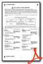
Airport Communications
| AWOS-3PT: | 119.55 Tel. 405-325-7302 |
|---|---|
| WESTHEIMER TOWER: | 118.0 |
| WESTHEIMER GROUND: | 121.6 |
| OKE CITY APPROACH: | 120.45 288.325 |
| OKE CITY DEPARTURE: | 120.45 288.325 |
| FAKEY RNAV STAR: | 124.6 266.8 |
| UNICOM: | 122.950 |
| JUDDG RNAV STAR: | 124.2 336.4 |
| WAYMAN RNAV STAR: | 124.2 336.4 |
| BASTS RNAV STAR: | 124.6 266.8 |
| CCASH RNAV STAR: | 124.6 266.8 |
| CTAF: | 118.000 |
| DAWKS RNAV STAR: | 124.6 266.8 |
| KRMSN DP: | 120.45 ;SOUTH 133.6 ;NORTH 273.52 ;NORTH 288.325 ;SOUTH |
| AWOS-1 at WX2 (0.0 S): | 119.55 817-222-4247 |
| ASOS at OKC (10.6 NW): | 405-674-4013 |
| D-ATIS at OKC (10.9 NW): | 125.85 |
Nearby Navigation Aids
|
| ||||||||||||||||||||||||||||||||||||||||||||||||||||||||||||


Runway 18/36
| Dimensions: | 5199 x 100 feet / 1585 x 30 meters | |
|---|---|---|
| Surface: | Asphalt / Grooved in Good Condition | |
| Weight Limits: | S-30, D-50, ST-100 | |
| Edge Lighting: | Medium Intensity | |
| Runway 18 | Runway 36 | |
| Coordinates: | N35°15.39' / W97°28.39' | N35°14.53' / W97°28.38' |
| Elevation: | 1181.6 | 1177.2 |
| Traffic Pattern: | Right | Left |
| Runway Heading: | 180° True | 360° True |
| Markings: | Precision Instrument in good condition. | Non-Precision Instrument in good condition. |
| Glide Slope Indicator | P4L (3.00° Glide Path Angle) | P4L (3.00° Glide Path Angle) |
| Approach Lights: | MALSR 1,400 Foot Medium-intensity Approach Lighting System with runway alignment indicator lights. | |
| REIL: | Yes | |
Runway 03/21
| Dimensions: | 4748 x 100 feet / 1447 x 30 meters | |
|---|---|---|
| Surface: | Asphalt in Good Condition | |
| Weight Limits: | S-30, D-50, ST-100 | |
| Edge Lighting: | Medium Intensity | |
| Runway 03 | Runway 21 | |
| Coordinates: | N35°14.17' / W97°28.55' | N35°14.80' / W97°27.98' |
| Elevation: | 1175.2 | 1179.1 |
| Traffic Pattern: | Left | Right |
| Runway Heading: | 36° True | 216° True |
| Markings: | Non-Precision Instrument in fair condition. | Non-Precision Instrument in fair condition. |
| Glide Slope Indicator | P4L (3.00° Glide Path Angle) | P4L (3.00° Glide Path Angle) |
| Approach Lights: | MALS 1,400 Foot Medium-intensity Approach Lighting System. | |
Services Available
| Fuel: | 100LL (blue), Jet A+ |
|---|---|
| Transient Storage: | Hangars,Tiedowns |
| Airframe Repair: | MAJOR |
| Engine Repair: | MAJOR |
| Bottled Oxygen: | NONE |
| Bulk Oxygen: | NONE |
| Other Services: | AVIONICS,PILOT INSTRUCTION,AIRCRAFT RENTAL |
Ownership Information
| Ownership: | Publicly owned | |
|---|---|---|
| Owner: | UNIV OF OKLAHOMA | |
| 1700 LEXINGTON AVE | ||
| NORMAN, OK 73069 | ||
| 405-325-7233 | ||
| Manager: | LANCE LAMKIN | |
| 1700 LEXINGTON AVE, SUITE 212 | ||
| NORMAN, OK 73069 | ||
| 405-325-7233 | ||
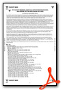
Other Remarks
- THIS AIRPORT HAS BEEN SURVEYED BY THE NATIONAL GEODETIC SURVEY.
- 180 DEG TURNS PROHIBITED ON RWYS FOR ALL OTHER THAN SINGLE ENGINE LIGHT ACFT.
- CTN: COYOTES & BIRDS ON & INVOF OF RWYS.
- HIGH DENSITY STUDENT OPNS INVOF ARPT & 5 MILES SOUTH.
- TPA FOR HELS 500 FT AGL; SINGLE ENGINE 1000 FT AGL; MULTI-ENGINE & JETS 1500 FT AGL.
- FOR CD IFUN TO CTC TWR, CTC OKE CITY APCH AT 405-681-5683.
- PPR RQRD ALL TSNT ACFT DAY BFR & DAY OF UNIVERSITY HOME FOOTBALL GAME AT 405-360-3900.
- PILOTS CONDUCTING EFVS OPS; BE AWARE LED ALS IN USE RWY 03.
- WHEN ATCT CLSD ACTVT MIRL RYS 03/21 & 18/36; REIL RY 36;MALSR RY 18 & MALS RY 03 - CTAF.
Weather Minimums
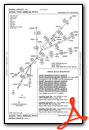
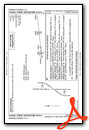
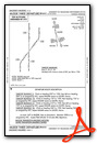
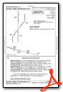
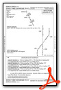
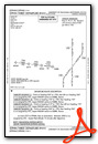
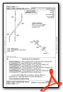
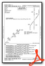
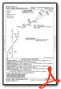
Standard Terminal Arrival (STAR) Charts
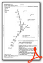


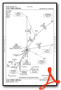

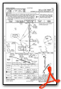
Instrument Approach Procedure (IAP) Charts
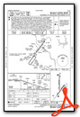

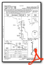
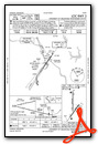
Departure Procedure (DP) Charts


Nearby Airports with Instrument Procedures
| ID | Name | Heading / Distance | ||
|---|---|---|---|---|
 |
1K4 | David Jay Perry Airport | 179° | 5.4 |
|
KOKC | Okc Will Rogers International Airport | 324° | 10.9 |
|
KTIK | Tinker AFB Airport | 022° | 11.0 |
|
KPWA | Wiley Post Airport | 333° | 19.3 |
|
KRCE | Clarence E Page Municipal Airport | 310° | 22.5 |
|
KHSD | Sundance Airport | 331° | 24.2 |
|
KCHK | Chickasha Municipal Airport | 250° | 25.9 |
|
KSNL | Shawnee Regional Airport | 075° | 26.8 |
|
KRQO | El Reno Regional Airport | 297° | 29.5 |
|
KPVJ | Pauls Valley Municipal Airport | 159° | 34.4 |
|
KGOK | Guthrie/Edmond Regional Airport | 004° | 36.4 |
|
KSRE | Seminole Municipal Airport | 087° | 39.2 |
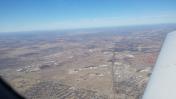
Airport Images
")
By: N714AJ
By: jngoka


