Login
Register


1K4
David Jay Perry Airport
Official FAA Data Effective 2026-01-22 0901Z
Chart Supplement

VFR Chart of 1K4
Sectional Charts at SkyVector.com
IFR Chart of 1K4
Enroute Charts at SkyVector.com
Location Information for 1K4
Coordinates: N35°9.30' / W97°28.22'Located 01 miles NE of Goldsby, Oklahoma on 392 acres of land. View all Airports in Oklahoma.
Surveyed Elevation is 1168 feet MSL.
Operations Data
|
|
Airport Communications
| OKE CITY APPROACH: | 120.45 288.325 |
|---|---|
| OKE CITY DEPARTURE: | 120.45 288.325 |
| CTAF: | 122.700 |
| UNICOM: | 122.700 |
| AWOS-3PT at OUN (5.3 N): | 119.55 405-325-7302 |
| AWOS-1 at WX2 (5.4 N): | 119.55 817-222-4247 |
| ASOS at OKC (15.4 NW): | 405-674-4013 |
Nearby Navigation Aids
|
| ||||||||||||||||||||||||||||||||||||||||||||||||||||||||||||


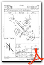
Runway 13/31
| Dimensions: | 3004 x 60 feet / 916 x 18 meters | |
|---|---|---|
| Surface: | Concrete / Grooved in Good Condition | |
| Weight Limits: | S-30 | |
| Edge Lighting: | Medium Intensity | |
| Runway 13 | Runway 31 | |
| Coordinates: | N35°9.47' / W97°28.42' | N35°9.10' / W97°28.01' |
| Elevation: | 1167.0 | 1156.6 |
| Traffic Pattern: | Left | Left |
| Runway Heading: | 136° True | 316° True |
| Markings: | Basic in good condition. | Non-Precision Instrument in good condition. |
| Obstacles: | 76 ft Trees 1380 ft from runway, 219 ft right of center | 35 ft Trees 1108 ft from runway, 78 ft right of center |
Runway 18/36
| Dimensions: | 1801 x 60 feet / 549 x 18 meters | |
|---|---|---|
| Surface: | Asphalt in Good Condition | |
| Weight Limits: | S-4 | |
| Runway 18 | Runway 36 | |
| Coordinates: | N35°9.48' / W97°28.23' | N35°9.19' / W97°28.24' |
| Elevation: | 1168.8 | 1160.8 |
| Traffic Pattern: | Left | Left |
| Runway Heading: | 181° True | 1° True |
| Markings: | Basic in fair condition. | Basic in fair condition. |
| Obstacles: | 45 ft Trees 806 ft from runway, 28 ft left of center | |
Services Available
| Fuel: | 100LL (blue) |
|---|---|
| Transient Storage: | Tiedowns |
| Airframe Repair: | NONE |
| Engine Repair: | NONE |
| Bottled Oxygen: | NONE |
| Bulk Oxygen: | NONE |
| Other Services: | PILOT INSTRUCTION,AIRCRAFT RENTAL |
Ownership Information
| Ownership: | Publicly owned | |
|---|---|---|
| Owner: | TOWN OF GOLDSBY | |
| 100 E. CENTER ROAD | ||
| GOLDSBY, OK 73093 | ||
| 405-288-6675 | ||
| Manager: | SATVIK NIMMAGADDA | |
| 351 DJP MEMORIAL BLVD., 100 E. CENTER ROAD | ||
| GOLDSBY, OK 73093 | ||
| 405-288-6675 | ||
Other Remarks
- INTENSIVE STUDENT TRNG DALGT HRS.
- ULTRALIGHT ACT ON & INVOF ARPT.
- COYOTES ON & INVOF RWY.
- FOR CD CTC OKE CITY APCH AT 405-681-5683.
- 0LL 24 HR AUTOMATED FUEL SERVICING SYSTEM.
- ACTVT MIRL RY 13/31 DUSK-DAWN - CTAF.
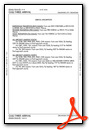
Weather Minimums

Standard Terminal Arrival (STAR) Charts
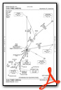
Instrument Approach Procedure (IAP) Charts
Nearby Airports with Instrument Procedures
| ID | Name | Heading / Distance | ||
|---|---|---|---|---|
 |
KOUN | University of Oklahoma Westheimer Airport | 359° | 5.4 |
|
KOKC | Okc Will Rogers International Airport | 335° | 15.6 |
|
KTIK | Tinker AFB Airport | 014° | 16.1 |
|
KPWA | Wiley Post Airport | 339° | 24.3 |
|
KCHK | Chickasha Municipal Airport | 262° | 24.7 |
|
KRCE | Clarence E Page Municipal Airport | 319° | 26.4 |
|
KSNL | Shawnee Regional Airport | 064° | 28.6 |
|
KHSD | Sundance Airport | 336° | 29.2 |
|
KPVJ | Pauls Valley Municipal Airport | 155° | 29.3 |
|
KRQO | El Reno Regional Airport | 306° | 32.5 |
|
KSRE | Seminole Municipal Airport | 079° | 39.7 |
|
O47 | Prague Municipal Airport | 061° | 41.7 |
Airport Images
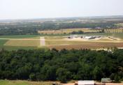
By: krruser


