Login
Register


IAN
Bob Baker Memorial Airport
Official FAA Data Effective 2025-12-25 0901Z
Chart Supplement

VFR Chart of PAIK
Sectional Charts at SkyVector.com
IFR Chart of PAIK
Enroute Charts at SkyVector.com
Location Information for PAIK
Coordinates: N66°58.57' / W160°26.32'Located 01 miles N of Kiana, Alaska. View all Airports in Alaska.
Surveyed Elevation is 178 feet MSL.
Operations Data
|
|
Airport Communications
| AWOS-3P: | 119.025 Tel. 907-475-2004 |
|---|---|
| CTAF: | 122.700 |
| AWOS-3P at D76 (16.7 SW): | 120.00 907-636-2010 |
| AWOS-3P at WLK (25.0 SE): | 135.65 907-484-2107 |
| AWOS-3P at BVK (62.1 S): | 135.15 907-494-2180 |
- APCH/DEP SVC PRVDD BY ANCHORAGE ARTCC ON FREQS 119.2/263.0 (KOTZEBUE RCAG).
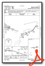
Nearby Navigation Aids
|
| ||||||||||||||||||

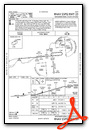
Runway 07/25
RWY SLOPES DOWN FROM 07 TO 25, GRADE 1%. | ||
| Dimensions: | 4000 x 75 feet / 1219 x 23 meters | |
|---|---|---|
| Surface: | Gravel in Good Condition | |
| Edge Lighting: | Medium Intensity | |
| Runway 07 | Runway 25 | |
| Coordinates: | N66°58.54' / W160°27.15' | N66°58.60' / W160°25.48' |
| Elevation: | 178.6 | 146.7 |
| Traffic Pattern: | Left | Left |
| Runway Heading: | 85° True | 265° True |
| Markings: | Non-Standard in good condition. | Non-Standard in good condition. |
| Glide Slope Indicator | P4R (3.00° Glide Path Angle) | |
| REIL: | Yes | |
| Obstacles: | 6 ft Brush 89 ft from runway, 95 ft left of center | |
Services Available
| Fuel: | NONE |
|---|---|
| Transient Storage: | NONE |
| Airframe Repair: | NONE |
| Engine Repair: | NONE |
| Bottled Oxygen: | NONE |
| Bulk Oxygen: | NONE |
| Other Services: | CHARTER SERVICE |
Ownership Information
| Ownership: | Publicly owned | |
|---|---|---|
| Owner: | ALASKA DOT&PF NORTHERN REGION | |
| 2301 PEGER RD | ||
| FAIRBANKS, AK 99709 | ||
| 907-451-2200 | ||
| Manager: | ALVIN WERNEKE | |
| BOX 55 | ||
| KOTZEBUE, AK 99752 | ||
| 907-442-3147 | ||
Other Remarks
- RWY CONDITION NOT MONITORED; RECOMMEND VISUAL INSPECTION PRIOR TO LANDING.
- RWY PLOWED IN WINTER.
- WX CAMERA AVBL ON INTERNET AT HTTPS://WEATHERCAMS.FAA.GOV
- COLD TEMPERATURE AIRPORT. ALTITUDE CORRECTION REQUIRED AT OR BELOW -28C.
- RWY 07/25 MARKED WITH LIGHTS AND PLASTIC MARKERS.
- NORTHWEST ARCTIC BOROUGH
- ACTVT REIL RWY 25; PAPI RWY 25; MIRL RWY 07/25 - CTAF.
- ACTVT ROTG BCN - CTAF.
Weather Minimums

Instrument Approach Procedure (IAP) Charts
Departure Procedure Obstacles (DPO) Charts
Nearby Airports with Instrument Procedures
| ID | Name | Heading / Distance | ||
|---|---|---|---|---|
 |
PFNO | Robert/Bob/Curtis Memorial Airport | 235° | 16.8 |
|
PASK | Selawik Airport | 154° | 25.1 |
|
PAOT | Ralph Wien Memorial Airport | 264° | 51.3 |
|
PAFM | Ambler Airport | 081° | 61.2 |
|
PABL | Buckland Airport | 196° | 62.3 |
|
PAWN | Noatak Airport | 301° | 68.9 |
|
PADE | Deering Airport | 226° | 78.2 |
Airport Images
Do you have a recent image of this airport? Upload it here!


