Login
Register


OUL
Nelson Lagoon Airport
Official FAA Data Effective 2025-12-25 0901Z
Chart Supplement

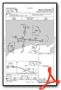
VFR Chart of PAOU
Sectional Charts at SkyVector.com
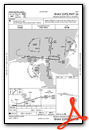
IFR Chart of PAOU
Enroute Charts at SkyVector.com
Location Information for PAOU
Coordinates: N56°0.45' / W161°9.62'Located 02 miles E of Nelson Lagoon, Alaska. View all Airports in Alaska.
Surveyed Elevation is 14 feet MSL.
Operations Data
|
|
Airport Communications
| AWOS-3P: | 119.025 Tel. 907-989-2227 |
|---|---|
| CTAF: | 122.900 |
| AWOS-3P at SDP (46.9 SE): | 134.85 907-560-7611 |
| AWOS-3P at KVC (65.5 SW): | 118.325 907-497-4279 |
| ASOS at CDB (71.2 SW): | 135.75 907-532-2639 |
- APCH/DEP SVC PRVDD BY ANCHORAGE ARTCC ON FREQS 118.5/278.3 (COLD BAY RCAG).
Nearby Navigation Aids
|
| ||||||||||||||||||||||||||||||||||||


Runway 08/26
| Dimensions: | 4003 x 75 feet / 1220 x 23 meters | |
|---|---|---|
| Surface: | Gravel-Dirt in Good Condition FIRST 300 FT RWY 08 SOFT IN MIDDLE. | |
| Edge Lighting: | Medium Intensity | |
| Runway 08 | Runway 26 | |
| Coordinates: | N56°0.49' / W161°10.21' | N56°0.42' / W161°9.04' |
| Elevation: | 14.0 | 10.0 |
| Traffic Pattern: | Left | |
| Runway Heading: | 96° True | 276° True |
| Markings: | Non-Standard in fair condition. | Non-Standard in fair condition. |
| Obstacles: | 5 ft Brush 0 ft from runway | 6 ft Brush 0 ft from runway |
Services Available
| Fuel: | 100LL (blue) |
|---|---|
| Transient Storage: | Tiedowns |
| Airframe Repair: | NONE |
| Engine Repair: | NONE |
| Bottled Oxygen: | NONE |
| Bulk Oxygen: | NONE |
Ownership Information
| Ownership: | Publicly owned | |
|---|---|---|
| Owner: | ALASKA DOT&PF SOUTHCOAST REGION | |
| P.O. BOX 112506 | ||
| JUNEAU, AK 99811-2506 | ||
| (907) 465-1779 | ||
| Manager: | HAROLD "HAP" KREMER | |
| BOX 97 | ||
| COLD BAY, AK 99571 | ||
| (907) 532-2579 | ||
Other Remarks
- LARGE SEA BIRDS ALONG BEACH ADJACENT TO RY.
- RY CONDITION NOT MONITORED; RECOMMEND VISUAL INSPECTION PRIOR TO USING.
- WX CAMERA AVBL ON INTERNET AT HTTPS://WEATHERCAMS.FAA.GOV
- ACTVT MIRL RY 08/26 - CTAF.
Weather Minimums

Instrument Approach Procedure (IAP) Charts
Departure Procedure Obstacles (DPO) Charts
Nearby Airports with Instrument Procedures
| ID | Name | Heading / Distance | ||
|---|---|---|---|---|
 |
PASD | Sand Point Airport | 152° | 47.0 |
|
PAVC | King Cove Airport | 215° | 65.5 |
|
PAPE | Perryville Airport | 094° | 67.7 |
|
PACD | Cold Bay Airport | 228° | 71.8 |
|
PAPH | Port Heiden Airport | 054° | 101.7 |
Airport Images
Do you have a recent image of this airport? Upload it here!


