Login
Register


PKB
Mid-Ohio Valley Regional Airport
Official FAA Data Effective 2025-12-25 0901Z
Chart Supplement

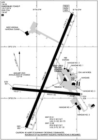
KPKB Airport Diagram
VFR Chart of KPKB
Sectional Charts at SkyVector.com
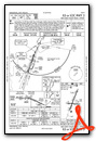
IFR Chart of KPKB
Enroute Charts at SkyVector.com
Location Information for KPKB
Coordinates: N39°20.70' / W81°26.36'Located 06 miles NE of Parkersburg, West Virginia on 1103 acres of land. View all Airports in West Virginia.
Surveyed Elevation is 858 feet MSL.
Operations Data
|
|
Airport Communications
| ATIS: | 124.35 |
|---|---|
| ASOS: | Tel. 304-464-1001 |
| PARKERSBURG TOWER: | 123.7 257.8 |
| PARKERSBURG GROUND: | 126.45 |
| EMERG: | 121.5 243.0 |
| UNICOM: | 122.950 |
| ARNG OPS: | 248.3 |
| CTAF: | 123.700 |
| AWOS-2 at I18 (30.6 SW): | 121.3 304-273-3424 |
| AWOS-3 at USW (31.6 S): | 118.575 304-927-0123 |
| AWOS-3 at UNI (37.6 W): | 128.325 740-597-2687 |
- APCH/DEP SVC PRVDD BY INDIANAPOLIS ARTCC ON FREQS 125.55/317.475 (PARKERSBURG RCAG).
Nearby Navigation Aids
|
| ||||||||||||||||||||||||||||||||||||||||||||||||||||||||||||


Runway 03/21
| Dimensions: | 7240 x 150 feet / 2207 x 46 meters | |
|---|---|---|
| Surface: | Asphalt / Grooved in Good Condition | |
| Weight Limits: | 31 /R/C/X/T, S-85, D-100, ST-175 | |
| Edge Lighting: | High Intensity | |
| Runway 03 | Runway 21 | |
| Coordinates: | N39°20.22' / W81°26.63' | N39°21.32' / W81°26.06' |
| Elevation: | 803.0 | 858.5 |
| Traffic Pattern: | Left | Left |
| Runway Heading: | 22° True | 202° True |
| Displaced Threshold: | 460 Feet | |
| Declared Distances: | TORA:7240 TODA:7240 ASDA:6780 LDA:6780 | TORA:7240 TODA:7240 ASDA:7240 LDA:6780 |
| Markings: | Precision Instrument in good condition. | Precision Instrument in good condition. |
| Glide Slope Indicator | P4L (3.00° Glide Path Angle) | P4R (3.00° Glide Path Angle) UNUSBL BYD 5 DEGS LEFT AND 9 DEGS RIGHT OF CNTRLN. |
| RVR Equipment | Touchdown Rollout | Touchdown Rollout |
| Approach Lights: | MALSR 1,400 Foot Medium-intensity Approach Lighting System with runway alignment indicator lights. | |
| REIL: | Yes | |
Runway 10/28
| Dimensions: | 4002 x 150 feet / 1220 x 46 meters | |
|---|---|---|
| Surface: | Asphalt / Grooved in Fair Condition | |
| Weight Limits: | 30 /R/C/X/T, S-50, D-75, ST-135 | |
| Edge Lighting: | High Intensity | |
| Runway 10 | Runway 28 | |
| Coordinates: | N39°20.60' / W81°26.80' | N39°20.54' / W81°25.96' |
| Elevation: | 830.7 | 838.3 |
| Traffic Pattern: | Left | Left |
| Runway Heading: | 95° True | 275° True |
| Declared Distances: | TORA:4002 TODA:4002 ASDA:4002 LDA:4002 | TORA:4002 TODA:4002 ASDA:4002 LDA:4002 |
| Markings: | Non-Precision Instrument in fair condition. | Non-Precision Instrument in fair condition. |
| Glide Slope Indicator | P2L (3.00° Glide Path Angle) | P2L (3.00° Glide Path Angle) UNUSBL BYD 8 DEGS LEFT AND 8 DEGS RIGHT OF CNTRLN. |
| REIL: | Yes | Yes |
Services Available
| Fuel: | 100LL (blue), Jet-A |
|---|---|
| Transient Storage: | Hangars,Tiedowns |
| Airframe Repair: | MINOR |
| Engine Repair: | MINOR |
| Bottled Oxygen: | NONE |
| Bulk Oxygen: | NONE |
| Other Services: | CHARTER SERVICE,PILOT INSTRUCTION,AIRCRAFT RENTAL,AIRCRAFT SALES |
Ownership Information
| Ownership: | Publicly owned | |
|---|---|---|
| Owner: | WOOD CO. ARPT AUTH | |
| P.O. BOX 4089 | FEDEX DELIVERY: 543 AIRPORT RD, WILLIAMSTOWN, WV 26187 | |
| PARKERSBURG, WV 26104-4089 | ||
| 304-464-5113 | ||
| Manager: | BENJAMIN AUVILLE | |
| ROUTE 31 & AIRPORT ROAD, BOX 4089 | ||
| WILLIAMSTOWN, WV 26187 | ||
| 304-464-5113 | ||
Other Remarks
- BIRDS & DEER ON & INVOF ARPT.
- NO LANDING FEE FOR ACFT LESS THAN 6500 LBS; FOR ACFT GREATER THAN 6500, LNDG FEE WAIVED WITH FUEL PURCHASES.
- ARNG OPS DSN 661-3400 C304-464-4530.
- WHEN ATCT CLSD, FOR CD CTC INDIANAPOLIS ARTCC AT 317-247-2411.
- WHEN ATCT CLSD ACTVT MALSR RWY 03; REIL RWY 10 & 21; HIRL RWY 03/21 & 10/28 - CTAF. PAPI RWY 03 & 21 OPR CONSLY. REIL RWY 28 UNAVBL WHEN ATCT CLSD.
Weather Minimums
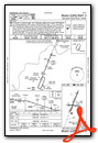
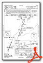
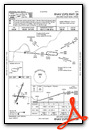
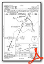
Instrument Approach Procedure (IAP) Charts

Nearby Airports with Instrument Procedures
| ID | Name | Heading / Distance | ||
|---|---|---|---|---|
 |
I10 | Noble County Airport | 350° | 27.7 |
|
4G5 | Monroe County Airport | 030° | 30.3 |
|
I18 | Jackson County Airport | 215° | 30.6 |
|
KUSW | Boggs Field Airport | 172° | 31.5 |
|
KUNI | Ohio University Airport | 258° | 37.7 |
|
KCDI | Cambridge Municipal Airport | 350° | 38.3 |
|
3I2 | Mason County Airport | 230° | 40.2 |
|
I86 | Ed Newlon Field Airport | 300° | 40.9 |
|
6G5 | Barnesville/Bradfield Airport | 016° | 41.0 |
|
KZZV | Zanesville Municipal Airport | 329° | 41.6 |
|
KGAS | Gallia-Meigs Regional Airport | 228° | 45.6 |
|
KMPG | Marshall County Airport | 045° | 45.8 |
Airport Images

By: Big Orange Bird

By: OverArmor


