Login
Register


GAS
Gallia-Meigs Regional Airport
Official FAA Data Effective 2026-01-22 0901Z
Chart Supplement

VFR Chart of KGAS
Sectional Charts at SkyVector.com
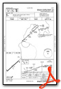
IFR Chart of KGAS
Enroute Charts at SkyVector.com
Location Information for KGAS
Coordinates: N38°50.05' / W82°9.81'Located 02 miles NE of Gallipolis, Ohio on 44 acres of land. View all Airports in Ohio.
Estimated Elevation is 565 feet MSL.
Operations Data
|
|
Airport Communications
| AWOS-3PT: | 119.925 Tel. 740-446-2149 |
|---|---|
| HUNTINGTON APPROACH: | 128.4 270.1 |
| HUNTINGTON DEPARTURE: | 128.4 270.1 |
| CLEARANCE DELIVERY: | 124.55 |
| CTAF: | 123.000 |
| UNICOM: | 123.000 |
| AWOS-3 at 3I2 (5.7 NE): | 119.675 304-675-4618 |
| AWOS-2 at I18 (17.1 E): | 121.3 304-273-3424 |
| AWOS-3PT at JRO (21.3 NW): | 118.825 740-286-1760 |
Nearby Navigation Aids
|
| ||||||||||||||||||||||||||||||||||||||||||||||||||||||||||||


Runway 05/23
| Dimensions: | 3999 x 75 feet / 1219 x 23 meters | |
|---|---|---|
| Surface: | Asphalt / Grooved in Good Condition | |
| Weight Limits: | S-30 | |
| Edge Lighting: | Medium Intensity | |
| Runway 05 | Runway 23 | |
| Coordinates: | N38°49.83' / W82°10.12' | N38°50.27' / W82°9.49' |
| Elevation: | 561.0 | 560.6 |
| Traffic Pattern: | Left | |
| Runway Heading: | 48° True | 228° True |
| Markings: | Non-Precision Instrument in good condition. | Non-Precision Instrument in good condition. |
| Glide Slope Indicator | P2L (3.00° Glide Path Angle) | P2L (3.00° Glide Path Angle) |
| REIL: | Yes | |
| Obstacles: | 45 ft Tree 660 ft from runway, 213 ft left of center CTLG OBSTN EXCEEDS A 45 DEG SLP. +10 FT ROAD, 170 FT DIST, L/R OF CNTRLN. |
10 ft Tree 205 ft from runway +5-17 FT TREES, 5-145 FT DIST, 75-181 FT L. |
Services Available
| Fuel: | 100LL (blue), Jet A-1 |
|---|---|
| Transient Storage: | Tiedowns |
| Airframe Repair: | NONE |
| Engine Repair: | NONE |
| Bottled Oxygen: | NONE |
| Bulk Oxygen: | NONE |
Ownership Information
| Ownership: | Publicly owned | |
|---|---|---|
| Owner: | GALLIA COUNTY COMMISSIONERS | GCBOC@GALLIANET.NET. |
| 18 LOCUST ST | ||
| GALLIPOLIS, OH 45631-1292 | ||
| 740-446-4374 | ||
| Manager: | KALEB ARMS | KARMS@GALLIANET.NET. |
| 312 AIRPORT RD | ||
| GALLIPOLIS, OH 45631 | ||
| 740-446-9004 | ||
Other Remarks
- THIS AIRPORT HAS BEEN SURVEYED BY THE NATIONAL GEODETIC SURVEY.
- DEER & BIRDS ON & INVOF ARPT.
- PARL TWY HAS LRG CRACKS & LOOSE GRVL.
- FOR CD CTC HUNTINGTON ATCT AT 304-453-2490.
- 0LL 100LL & A1 AVBL H24 SELF SER VIA CREDIT CARD.
- ACTVT REIL RWY 23; PAPI RWY 05 & 23; MIRL RWY 05/23 - CTAF.
Weather Minimums

Instrument Approach Procedure (IAP) Charts
Nearby Airports with Instrument Procedures
| ID | Name | Heading / Distance | ||
|---|---|---|---|---|
 |
3I2 | Mason County Airport | 032° | 5.7 |
|
I18 | Jackson County Airport | 070° | 17.1 |
|
KJRO | James A Rhodes Airport | 294° | 21.3 |
|
KUNI | Ohio University Airport | 352° | 22.9 |
|
12V | Ona Airpark Airport | 184° | 23.6 |
|
KDWU | Ashland Regional Airport | 238° | 31.8 |
|
KPMH | Greater Portsmouth Regional Airport | 270° | 32.1 |
|
KHTS | Tri-State/Milton J Ferguson Field Airport | 213° | 33.6 |
|
KUSW | Boggs Field Airport | 090° | 38.2 |
|
KCRW | West Virginia International Yeager Airport | 135° | 38.4 |
|
KEOP | Pike County Airport | 299° | 41.0 |
|
KPKB | Mid-Ohio Valley Regional Airport | 047° | 45.6 |
Airport Images
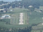
By: Big Orange Bird

By: jderosa


