Login
Register


PNM
Princeton Municipal Airport
Official FAA Data Effective 2025-11-27 0901Z
Chart Supplement

VFR Chart of KPNM
Sectional Charts at SkyVector.com
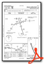
IFR Chart of KPNM
Enroute Charts at SkyVector.com
Location Information for KPNM
Coordinates: N45°33.59' / W93°36.49'Located 01 miles SW of Princeton, Minnesota on 304 acres of land. View all Airports in Minnesota.
Surveyed Elevation is 979 feet MSL.
Operations Data
|
|
Airport Communications
| AWOS-3: | 119.025 Tel. 763-389-0615 |
|---|---|
| UNICOM: | 123.000 |
| CTAF: | 123.000 |
| AWOS-3PT at CBG (14.5 E): | 121.125 763-689-9562 |
| ASOS at STC (19.0 W): | 125.075 320-200-1187 |
| ATIS at STC (19.0 W): | 119.375 |
- APCH/DEP SVC PRVDD BY MINNEAPOLIS ARTCC ON FREQS 121.05/235.775 (PRINCETON RCAG).
Nearby Navigation Aids
|
| ||||||||||||||||||||||||||||||||||||||||||||||||||||||||||||


Runway 16/34
| Dimensions: | 3900 x 75 feet / 1189 x 23 meters | |
|---|---|---|
| Surface: | Asphalt in Good Condition | |
| Edge Lighting: | Medium Intensity | |
| Runway 16 | Runway 34 | |
| Coordinates: | N45°33.89' / W93°36.67' | N45°33.29' / W93°36.32' |
| Elevation: | 979.6 | 978.9 |
| Traffic Pattern: | Left | Left |
| Runway Heading: | 158° True | 338° True |
| Markings: | Non-Precision Instrument in good condition. | Non-Precision Instrument in good condition. |
| Glide Slope Indicator | P4L (3.00° Glide Path Angle) PAPI UNUSBL BYD 6 DEGS LEFT OF CNTRLN. | P4R (3.00° Glide Path Angle) |
| REIL: | Yes | Yes |
| Obstacles: | 19 ft Tree 379 ft from runway, 172 ft left of center | |
Services Available
| Fuel: | 100LL (blue) |
|---|---|
| Transient Storage: | Tiedowns |
| Airframe Repair: | NONE |
| Engine Repair: | NONE |
| Bottled Oxygen: | NONE |
| Bulk Oxygen: | NONE |
| Other Services: | AIRCRAFT RENTAL,AIRCRAFT SALES,ANNUAL SURVEYING |
Ownership Information
| Ownership: | Publicly owned | |
|---|---|---|
| Owner: | CITY OF PRINCETON | |
| 705 N 2ND ST | ||
| PRINCETON, MN 55371-1558 | ||
| 763-389-2040 | ||
| Manager: | MICHELE MCPHERSON | |
| 705 N 2ND ST | ||
| PRINCETON, MN 55371-1558 | ||
| 763-389-2040 | ||
Other Remarks
- OCNL HEL OPS INVOF ARPT; LGTD HOSP HELI 1 NM ESE.
- ULTRALIGHTS ON & INVOF ARPT.
- FOR CD IF UNA TO CTC ON FSS FREQ, CTC MINNEAPOLIS ARTCC AT 651-463-5588.
- 0LL FUEL AVBL H24 WITH CREDIT CARD.
- ACTVT REIL RWY 16 & 34; PAPI RWY 16 & 34; MIRL RWY 16/34 - CTAF.
Weather Minimums

Instrument Approach Procedure (IAP) Charts

Nearby Airports with Instrument Procedures
| ID | Name | Heading / Distance | ||
|---|---|---|---|---|
 |
KCBG | Cambridge Municipal Airport | 090° | 14.5 |
|
KSTC | St Cloud Regional Airport | 267° | 19.0 |
|
KJMR | Mora Municipal Airport | 035° | 24.4 |
|
KMGG | Maple Lake Municipal-Bill Mavencamp Sr Field Airport | 219° | 25.1 |
|
KCFE | Buffalo Municipal Airport | 202° | 26.0 |
|
KROS | Rush City Regional Airport | 073° | 28.8 |
|
KANE | Anoka County/Blaine (Janes Field) Airport | 145° | 30.1 |
|
KMIC | Crystal Airport | 160° | 31.7 |
|
KLXL | Little Falls/Morrison County-Lindbergh Field Airport | 307° | 38.8 |
|
04W | Field of Dreams Airport | 046° | 40.8 |
|
KOEO | L O Simenstad Municipal Airport | 110° | 41.6 |
|
KGTG | Grantsburg Municipal Airport | 069° | 42.2 |
Airport Images
Do you have a recent image of this airport? Upload it here!


