Login
Register


RZN
Burnett County Airport
Official FAA Data Effective 2026-01-22 0901Z
Chart Supplement

VFR Chart of KRZN
Sectional Charts at SkyVector.com
IFR Chart of KRZN
Enroute Charts at SkyVector.com
Location Information for KRZN
Coordinates: N45°49.41' / W92°22.42'Located 03 miles N of Siren, Wisconsin on 576 acres of land. View all Airports in Wisconsin.
Surveyed Elevation is 989 feet MSL.
Operations Data
|
|
Airport Communications
| AWOS-3: | 118.325 Tel. 715-349-8563 |
|---|---|
| CTAF: | 122.800 |
| UNICOM: | 122.800 |
| AWOS-3 at 04W (24.9 NW): | 118.225 320-384-6169 |
| AWOS-3PT at UBE (25.2 SE): | 119.175 715-822-3452 |
| AWOS-3 at ROS (25.5 W): | 118.8 320-358-3339 |
- APCH/DEP SVC PRVDD BY MINNAEPOLIS ARTCC ON FREQS 121.05/235.775 (PRINCETON RCAG).
Nearby Navigation Aids
|
| ||||||||||||||||||||||||||||||||||||||||||||||||||||||||||||


Runway 14/32
| Dimensions: | 5000 x 75 feet / 1524 x 23 meters | |
|---|---|---|
| Surface: | Asphalt in Fair Condition | |
| Weight Limits: | S-8 | |
| Edge Lighting: | Medium Intensity | |
| Runway 14 | Runway 32 | |
| Coordinates: | N45°49.70' / W92°22.87' | N45°49.10' / W92°22.06' |
| Elevation: | 987.2 | 987.6 |
| Traffic Pattern: | Left | Left |
| Runway Heading: | 137° True | 317° True |
| Displaced Threshold: | 340 Feet | |
| Markings: | Non-Precision Instrument in good condition. | Non-Precision Instrument in good condition. |
| Glide Slope Indicator | P2L (3.00° Glide Path Angle) | P2L (4.00° Glide Path Angle) |
| REIL: | Yes | Yes |
| Obstacles: | 85 ft Trees 1378 ft from runway, 115 ft left of center APCH RATIO 20:1 TO DTHR. |
|
Runway 05/23
| Dimensions: | 3900 x 75 feet / 1189 x 23 meters | |
|---|---|---|
| Surface: | Asphalt in Excellent Condition | |
| Weight Limits: | S-8 | |
| Edge Lighting: | Medium Intensity | |
| Runway 05 | Runway 23 | |
| Coordinates: | N45°49.19' / W92°22.69' | N45°49.64' / W92°22.03' |
| Elevation: | 989.2 | 984.0 |
| Traffic Pattern: | Left | Left |
| Runway Heading: | 45° True | 225° True |
| Markings: | Non-Precision Instrument in good condition. | Non-Precision Instrument in good condition. |
| Glide Slope Indicator | P2L (3.50° Glide Path Angle) UNUSBL BYD 5 DEGS RIGHT OF CNTRLN. | P2L (3.00° Glide Path Angle) |
| REIL: | Yes | Yes |
| Obstacles: | 35 ft Trees 500 ft from runway, 260 ft right of center | 15 ft Road 382 ft from runway, 277 ft left of center |
Services Available
| Fuel: | 100LL (blue), Jet A+ |
|---|---|
| Transient Storage: | Hangars,Tiedowns |
| Airframe Repair: | MINOR |
| Engine Repair: | MINOR |
| Bottled Oxygen: | NOT AVAILABLE |
| Bulk Oxygen: | NOT AVAILABLE |
| Other Services: | PILOT INSTRUCTION |
Ownership Information
| Ownership: | Publicly owned | |
|---|---|---|
| Owner: | BURNETT COUNTY | |
| 7410 CTH K | ||
| SIREN, WI 54872 | ||
| 715-349-2904 | ||
| Manager: | NATHAN EHALT | |
| 7410 CTH K, SUITE #116 | ||
| SIREN, WI 54872 | ||
| 715-222-1702 | AFT HR - 715-222-1702/715-566-2557. | |
Other Remarks
- WILDLIFE ON & INVOF OF RWY.
- FOR CD CTC MINNEAPOLIS ARTCC AT 651-463-5588.
- 0LL SELF SVC H24 WITH CREDIT CARD.
- ACTVT REIL RWY 05, 14, 23 & 32; PAPI RWY 05, 14, 23 & 32; MIRL RWY 05/23 & 14/32 - CTAF. SS-SR: MIRL RWY 14/32 PRESET TO LOW; INCR INTST - CTAF.
Weather Minimums


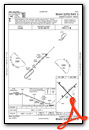
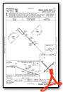
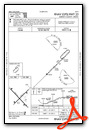
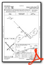
Instrument Approach Procedure (IAP) Charts
Nearby Airports with Instrument Procedures
| ID | Name | Heading / Distance | ||
|---|---|---|---|---|
 |
KGTG | Grantsburg Municipal Airport | 263° | 12.3 |
|
KSSQ | Shell Lake Municipal Airport | 106° | 19.8 |
|
04W | Field of Dreams Airport | 298° | 24.9 |
|
KUBE | Cumberland Municipal Airport | 138° | 25.2 |
|
KROS | Rush City Regional Airport | 252° | 25.5 |
|
KAHH | Amery Municipal Airport | 180° | 32.5 |
|
KOEO | L O Simenstad Municipal Airport | 203° | 33.6 |
|
KRPD | Rice Lake Regional/Carl's Field Airport | 133° | 35.0 |
|
KOLG | Solon Springs Municipal Airport | 038° | 37.6 |
|
KJMR | Mora Municipal Airport | 276° | 37.9 |
|
KMZH | Moose Lake Carlton County Airport | 333° | 40.0 |
|
KCBG | Cambridge Municipal Airport | 247° | 40.7 |
Airport Images
Do you have a recent image of this airport? Upload it here!


