Login
Register


AHH
Amery Municipal Airport
Official FAA Data Effective 2025-11-27 0901Z
Chart Supplement

VFR Chart of KAHH
Sectional Charts at SkyVector.com
IFR Chart of KAHH
Enroute Charts at SkyVector.com
Location Information for KAHH
Coordinates: N45°16.87' / W92°22.52'Located 02 miles S of Amery, Wisconsin on 218 acres of land. View all Airports in Wisconsin.
Surveyed Elevation is 1088 feet MSL.
Operations Data
|
|
Airport Communications
| CTAF: | 122.800 |
|---|---|
| UNICOM: | 122.800 |
| AWOS-3 at RNH (10.4 SW): | 120.0 715-246-3202 |
| AWOS-3 at OEO (13.6 W): | 119.925 715-294-3845 |
| AWOS-3PT at UBE (21.4 NE): | 119.175 715-822-3452 |
- APCH/DEP SVC PRVDD BY MINNAEPOLIS ARTCC ON FREQS 125.3/335.6 EAU CLAIRE RCAG).
Nearby Navigation Aids
|
| ||||||||||||||||||||||||||||||||||||||||||||||||||||||||||||


Runway 18/36
| Dimensions: | 4002 x 75 feet / 1220 x 23 meters | |
|---|---|---|
| Surface: | Asphalt in Good Condition | |
| Weight Limits: | S-12 | |
| Edge Lighting: | Medium Intensity | |
| Runway 18 | Runway 36 | |
| Coordinates: | N45°17.20' / W92°22.54' | N45°16.54' / W92°22.51' |
| Elevation: | 1078.3 | 1088.1 |
| Runway Heading: | 178° True | 358° True |
| Markings: | Non-Precision Instrument in fair condition. | Non-Precision Instrument in fair condition. |
| Glide Slope Indicator | P4L (4.00° Glide Path Angle) UNUSBL BYD 8 DEG RIGHT OF CNTRLN. | P4L (3.00° Glide Path Angle) |
| REIL: | Yes | Yes |
| Obstacles: | 28 ft Tree 650 ft from runway, 210 ft left of center | |
Services Available
| Fuel: | 100LL (blue), Jet-A |
|---|---|
| Transient Storage: | Hangars,Tiedowns |
| Airframe Repair: | NONE |
| Engine Repair: | NONE |
| Bottled Oxygen: | NONE |
| Bulk Oxygen: | NONE |
Ownership Information
| Ownership: | Publicly owned | |
|---|---|---|
| Owner: | CITY OF AMERY | |
| 104 MAPLE STREET W, SUITE A | ||
| AMERY, WI 54001 | ||
| 715-268-3411 | ||
| Manager: | RAY TOLLIVER | |
| 104 MAPLE STREET W, SUITE A | ||
| AMERY, WI 54001 | ||
| 715-268-8932 | ||
Other Remarks
- FOR CD CTC MINNEAPOLIS ARTCC AT 651-463-5588.
- 0LL FUEL AVBL H24 VIA CREDIT CARD.
- MIRL RWY 18/36 PRESET TO LOW SS-SR; TO INCR INTST AND ACTVT REIL RWY 18 & 36; PAPI RWY 18 & 36 - CTAF.
Weather Minimums
Instrument Approach Procedure (IAP) Charts


Nearby Airports with Instrument Procedures
| ID | Name | Heading / Distance | ||
|---|---|---|---|---|
 |
KRNH | New Richmond Regional Airport | 221° | 10.6 |
|
KOEO | L O Simenstad Municipal Airport | 277° | 13.4 |
|
3T3 | Boyceville Municipal Airport | 133° | 20.7 |
|
KUBE | Cumberland Municipal Airport | 050° | 21.5 |
|
21D | Lake Elmo Airport | 230° | 26.5 |
|
KRPD | Rice Lake Regional/Carl's Field Airport | 071° | 26.8 |
|
Y23 | Chetek Municipal/Southworth Airport | 086° | 31.3 |
|
KLUM | Menomonie Municipal/Score Field Airport | 137° | 31.8 |
|
KRZN | Burnett County Airport | 000° | 32.5 |
|
KSSQ | Shell Lake Municipal Airport | 035° | 33.1 |
|
KGTG | Grantsburg Municipal Airport | 338° | 33.3 |
|
KROS | Rush City Regional Airport | 315° | 34.9 |
Airport Images
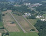
By: WisDOT Aeronautics


