Login
Register


S64
Stanford/Biggerstaff Field Airport
Official FAA Data Effective 2026-01-22 0901Z
Chart Supplement

VFR Chart of S64
Sectional Charts at SkyVector.com
IFR Chart of S64
Enroute Charts at SkyVector.com
Location Information for S64
Coordinates: N47°8.81' / W110°13.80'Located 01 miles S of Stanford, Montana on 133 acres of land. View all Airports in Montana.
Surveyed Elevation is 4327 feet MSL.
Operations Data
|
|
Airport Communications
| CTAF: | 122.800 |
|---|---|
| UNICOM: | 122.800 |
| ASOS at LWT (31.7 E): | 118.375 406-538-2653 |
| AWOS-3PT at 79S (45.0 N): | 121.125 406-622-5976 |
| AWOS-3PT at 7S6 (48.1 SW): | 118.525 406-547-3511 |
- APCH/DEP SVC PRVDD BY SALT LAKE ARTCC (ZLC) ON FREQS 133.4/285.4 (JUDITH MOUNTAIN RCAG).
Nearby Navigation Aids
|
| ||||||||||||||||||||||||||||||||||||


Runway 12/30
| Dimensions: | 4200 x 75 feet / 1280 x 23 meters | |
|---|---|---|
| Surface: | Asphalt in Excellent Condition | |
| Weight Limits: | S-12 | |
| Edge Lighting: | Medium Intensity | |
| Runway 12 | Runway 30 | |
| Coordinates: | N47°9.08' / W110°14.24' | N47°8.66' / W110°13.43' |
| Elevation: | 4324.5 | 4313.2 |
| Traffic Pattern: | Left | Left |
| Markings: | Non-Precision Instrument in fair condition. | Non-Precision Instrument in fair condition. |
| Glide Slope Indicator | P2L (3.00° Glide Path Angle) | |
Runway 07/25
| Dimensions: | 1600 x 100 feet / 488 x 30 meters | |
|---|---|---|
| Surface: | Turf in Poor Condition TALL GRASS. | |
| Runway 07 | Runway 25 | |
| Coordinates: | N47°8.66' / W110°13.91' | N47°8.66' / W110°13.52' |
| Elevation: | 4327.6 | 4316.7 |
| Traffic Pattern: | Left | Left |
| Markings: | None | None |
Services Available
| Fuel: | NONE |
|---|---|
| Transient Storage: | Hangars,Tiedowns |
| Airframe Repair: | NONE |
| Engine Repair: | NONE |
| Bottled Oxygen: | NONE |
| Bulk Oxygen: | NONE |
Ownership Information
| Ownership: | Publicly owned | |
|---|---|---|
| Owner: | JUDITH BASIN COUNTY | |
| COUNTY COURTHOUSE PO 427 | ||
| STANFORD, MT 59479 | ||
| 406-566-2277 | ||
| Manager: | TYLER YOUDERIAN | |
| PO BOX 400 | ||
| STANFORD, MT 59479 | ||
| 406-490-7708 | ||
Other Remarks
- CONDS NOT RPRTD CTC AMGR 406-490-7708.
- FOR CD CTC SALT LAKE ARTCC AT 801-320-2568.
- ACTVT PAPI RWY 30; MIRL RWY 12/30 - CTAF.
Weather Minimums

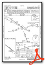
Instrument Approach Procedure (IAP) Charts

Nearby Airports with Instrument Procedures
| ID | Name | Heading / Distance | ||
|---|---|---|---|---|
 |
KLWT | Lewistown Municipal Airport | 100° | 31.8 |
|
KHWQ | Wheatland County At Harlowton Airport | 159° | 44.7 |
|
79S | Fort Benton Airport | 338° | 45.0 |
|
7S6 | White Sulphur Springs Airport | 215° | 48.1 |
|
KGTF | Great Falls International Airport | 293° | 50.7 |
|
KHLN | Helena Regional Airport | 246° | 79.1 |
|
KRPX | Roundup Airport | 119° | 80.4 |
|
6S0 | Big Timber At Howard Field Airport | 172° | 81.1 |
|
KHVR | Havre City-County Airport | 012° | 85.9 |
|
KLVM | Mission Field Airport | 186° | 87.3 |
|
KCII | Choteau Airport | 298° | 88.8 |
|
KBZN | Bozeman Yellowstone International Airport | 205° | 90.6 |
Airport Images
Do you have a recent image of this airport? Upload it here!


