Login
Register


BZN
Bozeman Yellowstone International Airport
Official FAA Data Effective 2026-02-19 0901Z
From the Flight Deck
Chart Supplement

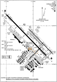
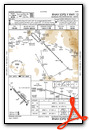
KBZN Airport Diagram
VFR Chart of KBZN
Sectional Charts at SkyVector.com
IFR Chart of KBZN
Enroute Charts at SkyVector.com
Location Information for KBZN
Coordinates: N45°46.63' / W111°9.02'Located 07 miles NW of Bozeman, Montana on 2481 acres of land. View all Airports in Montana.
Surveyed Elevation is 4473 feet MSL.
Operations Data
|
|
Airport Communications
| ATIS: | 135.425 (406-388-4767) |
|---|---|
| ASOS: | Tel. 406-388-4882 |
| BOZEMAN TOWER: | 118.2 |
| BOZEMAN GROUND: | 121.8 |
| BIG SKY APPROACH: | 118.975 226.675 |
| BIG SKY DEPARTURE: | 118.975 226.675 |
| CLEARANCE DELIVERY: | 124.05 |
| CTAF: | 118.200 |
| UNICOM: | 122.950 |
| ASOS at LVM (29.8 E): | 135.275 406-222-2338 |
| AWOS-3P at EKS (36.8 SW): | 119.85 406-682-3835 |
| AWOS-3PT at 7S6 (44.3 N): | 118.525 406-547-3511 |
- COMMUNICATIONS PRVDD BY GREAT FALLS RADIO ON FREQ 122.5 (BOZEMAN RCO).
- APCH/DEP CTL SVC PRVDD BY BIG SKY APCH CTL (BOI) ON FREQ 118.975/226.675 FM 0600-0015 LCL. SALT LAKE ARTCC (ZLC) PRVDD'S APCH/DEP SVC ON 118.975/226.675 ( BOZEMAN A RCAG) FM 0015-0600 LCL.
Nearby Navigation Aids
|
| ||||||||||||||||||||||||||||||||||||||||||


Runway 12/30
| Dimensions: | 8994 x 150 feet / 2741 x 46 meters | |
|---|---|---|
| Surface: | Asphalt / Grooved in Good Condition | |
| Weight Limits: | S-120, D-250, ST-550, DT-1120
PCR VALUE: 1410/F/A/X/U
| |
| Edge Lighting: | High Intensity | |
| Runway 12 | Runway 30 | |
| Coordinates: | N45°47.29' / W111°9.99' | N45°46.22' / W111°8.51' |
| Elevation: | 4424.9 | 4462.3 |
| Traffic Pattern: | Left | Left |
| Runway Heading: | 136° True | 316° True |
| Declared Distances: | TORA:8994 TODA:8994 ASDA:8994 LDA:8994 | TORA:8994 TODA:8994 ASDA:8994 LDA:8994 |
| Markings: | Precision Instrument in good condition. | Precision Instrument in good condition. |
| Glide Slope Indicator | P4L (3.00° Glide Path Angle) | P4L (3.20° Glide Path Angle) |
| RVR Equipment | Touchdown Midfield Rollout | Touchdown Midfield Rollout |
| Approach Lights: | MALSR 1,400 Foot Medium-intensity Approach Lighting System with runway alignment indicator lights. | MALSR 1,400 Foot Medium-intensity Approach Lighting System with runway alignment indicator lights. |
Runway 11/29
| Dimensions: | 5050 x 75 feet / 1539 x 23 meters | |
|---|---|---|
| Surface: | Asphalt / Grooved in Good Condition | |
| Weight Limits: | S-12
PCR VALUE: 260/F/A/X/U
| |
| Edge Lighting: | Medium Intensity | |
| Runway 11 | Runway 29 | |
| Coordinates: | N45°46.89' / W111°9.13' | N45°46.29' / W111°8.30' |
| Elevation: | 4441.8 | 4461.4 |
| Runway Heading: | 136° True | 316° True |
| Declared Distances: | TORA:5050 TODA:5050 ASDA:5050 LDA:5050 | TORA:5050 TODA:5050 ASDA:5050 LDA:5050 |
| Markings: | Basic in good condition. | Basic in good condition. |
| Glide Slope Indicator | P4L (3.00° Glide Path Angle) | P4L (3.00° Glide Path Angle) |
Runway 11G/29G
240 FT S OF RWY 11/29; AVBL WHEN DRY WITH ATC APVL. | ||
| Dimensions: | 2802 x 80 feet / 854 x 24 meters | |
|---|---|---|
| Surface: | Turf in Good Condition | |
| Runway 11G | Runway 29G | |
| Coordinates: | N45°46.82' / W111°9.11' | N45°46.49' / W111°8.65' |
| Elevation: | 4444.2 | 4453.2 |
| Runway Heading: | 136° True | 316° True |
| Markings: | Non-Standard | Non-Standard |
Runway 03/21
| Dimensions: | 2650 x 75 feet / 808 x 23 meters | |
|---|---|---|
| Surface: | Asphalt / Grooved in Good Condition | |
| Weight Limits: | S-12
PCR VALUE: 465/F/A/X/U
| |
| Runway 03 | Runway 21 | |
| Coordinates: | N45°46.13' / W111°9.15' | N45°46.44' / W111°8.71' |
| Elevation: | 4473.4 | 4454.7 |
| Traffic Pattern: | Left | Left |
| Runway Heading: | 46° True | 226° True |
| Declared Distances: | TORA:2650 TODA:2650 ASDA:2650 LDA:2650 | TORA:2650 TODA:2650 ASDA:2650 LDA:2650 |
| Markings: | Basic in good condition. | Basic in good condition. |
Services Available
| Fuel: | 100 (green), 100LL (blue), Jet-A |
|---|---|
| Transient Storage: | Hangars,Tiedowns |
| Airframe Repair: | MAJOR |
| Engine Repair: | MAJOR |
| Bottled Oxygen: | HIGH/LOW |
| Bulk Oxygen: | HIGH/LOW |
| Other Services: | AIR FREIGHT SERVICES,CROP DUSTING SERVICES,CHARTER SERVICE,GLIDER SERVICE,PILOT INSTRUCTION,PARACHUTE JUMP ACTIVITY,AIRCRAFT RENTAL,AIRCRAFT SALES,ANNUAL SURVEYING,GLIDER TOWING SERVICES |
Ownership Information
| Ownership: | Publicly owned | |
|---|---|---|
| Owner: | GALLATIN AIRPORT AUTHORITY | |
| 850 GALLATIN FIELD RD, SUITE 6 | ||
| BELGRADE, MT 59714 | ||
| 406-388-6632 | ||
| Manager: | BRIAN SPRENGER | |
| 850 GALLATIN FIELD RD, SUITE 6 | ||
| BELGRADE, MT 59714 | ||
| 406-388-6632 | ||
Other Remarks
- BIRDS INVOF ARPT.
- STUDENT TRNG ACT WI 15 MI.
- 180 DEG TURN NA ON TRML RAMP.
- PILOTS CONDUCTING EFVS OPS; BE AWARE LED ALS IN USE RWY 12.
- FOR CD WHEN ATCT CLSD CTC BIG SKY APCH AT 208-364-5860, WHEN ATCT AND APCH CLSD CTC SALT LAKE ARTCC AT 801-320-2568.
- NOISE: TRAINING TRAFFIC - CHECK VOLUNTARY NOISE ABATEMENT PRO
- SNOW REMOVAL EQUIP - CTAF.
- COLD TEMPERATURE AIRPORT. ALTITUDE CORRECTION REQUIRED AT OR BELOW -21C.
- TKOF NA UNTIL CFMG NO TFC USING RWY 12.
- ARR & DEP OPS WHEN WIND LESS THAN 10 KT; OTR RWY MAY BE USED; EXPC DLA.
- LCTD BTN RWY 12/30 & TWY A; AVBL GTR THAN 12500 LB DAY/VFR ONLY.
- CONES.
- CONES.
- WHEN ATCT CLSD ACTVT MALSR RWY 12 & 30; HIRL RWY 12/30; MIRL RWY 11/29 - CTAF. PAPI RWY 12 & 30 OPR CONSLY.
- U.S. CUSTOMS AVBL 1600Z-2400Z THU-MON.
Weather Minimums


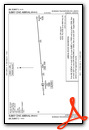
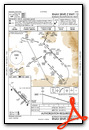
Standard Terminal Arrival (STAR) Charts

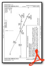

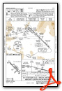
Instrument Approach Procedure (IAP) Charts


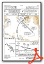


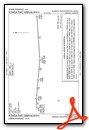
Departure Procedure (DP) Charts


Departure Procedure Obstacles (DPO) Charts

Nearby Airports with Instrument Procedures
| ID | Name | Heading / Distance | ||
|---|---|---|---|---|
 |
KLVM | Mission Field Airport | 098° | 29.9 |
|
KEKS | Ennis Big Sky Airport | 215° | 36.7 |
|
7S6 | White Sulphur Springs Airport | 012° | 44.2 |
|
6S0 | Big Timber At Howard Field Airport | 087° | 49.2 |
|
KRVF | Ruby Valley Field Airport | 253° | 50.6 |
|
KBTM | Bert Mooney Airport | 281° | 57.5 |
|
KHLN | Helena Regional Airport | 325° | 60.7 |
|
KWYS | Yellowstone Airport | 178° | 65.4 |
|
KDLN | Dillon Airport | 242° | 66.9 |
|
KHWQ | Wheatland County At Harlowton Airport | 052° | 67.5 |
|
3U3 | Bowman Field Airport | 288° | 75.3 |
|
38S | Deer Lodge-City-County Airport | 299° | 76.7 |
Fuel Providers

Airport Images
Do you have a recent image of this airport? Upload it here!


