Login
Register
SBGV
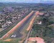
Coronel Altino Machado Airport
VFR Chart of SBGV
Sectional Charts at SkyVector.com
IFR Chart of SBGV
Enroute Charts at SkyVector.com
Location Information for SBGV
Coordinates: S18°53.82' / W41°59.17'View all Airports in Minas Gerais, Brazil.
Elevation is 563.0 feet MSL.
Operations Data
|
|
Airport Communications
| RADIO VALADARES Information: | 132.05 |
|---|
Nearby Navigation Aids
|
| ||||||||||||||||||||||||||||||||||||||||||
Runway 07/25
| Dimensions: | 5581 x 98 feet / 1701 x 30 meters | |
|---|---|---|
| Surface: | Hard | |
| Runway 07 | Runway 25 | |
| Coordinates: | S18°54.02' / W41°59.25' | S18°53.44' / W41°58.65' |
| Elevation: | 561 | 561 |
| Runway Heading: | 068° | 248° |
| Displaced Threshold: | 659 Feet | |
Nearby Airports with Instrument Procedures
| ID | Name | Heading / Distance | ||
|---|---|---|---|---|
 |
SBIP | Usiminas Airport | 219° | 44.6 |
 |
SBLS | Lagoa Santa Airport | 246° | 117.7 |
 |
SBCF | Tancredo Neves - International Airport | 248° | 120.8 |
 |
SBBH | Pampulha-Carlos Drummond De A Airport | 242° | 125.2 |
 |
SBVT | Eurico De Aguiar Salles Airport | 130° | 126.1 |
 |
SI39 | Nilo Bicalho Airport | 306° | 160.7 |


