Login
Register


BTM
Bert Mooney Airport
Official FAA Data Effective 2026-02-19 0901Z
Chart Supplement

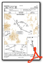
KBTM Airport Diagram

VFR Chart of KBTM
Sectional Charts at SkyVector.com
IFR Chart of KBTM
Enroute Charts at SkyVector.com
Location Information for KBTM
Coordinates: N45°57.29' / W112°29.85'Located 03 miles SE of Butte, Montana on 890 acres of land. View all Airports in Montana.
Surveyed Elevation is 5550 feet MSL.
Operations Data
|
|
Airport Communications
| ASOS: | 135.175 Tel. 406-494-1870 |
|---|---|
| CTAF: | 123.000 |
| UNICOM: | 123.000 |
| AWOS-3PT at 3U3 (19.5 NW): | 124.175 406-563-8275 |
| AWOS-3PT at RVF (25.7 S): | 119.025 406-684-5285 |
| AWOS-AV at 38S (28.4 NW): | 120.025 406-846-1177 |
- APCH/DEP CTL SVC PRVDD BY SALT LAKE ARTCC (ZLC) ON FREQS 132.4/338.3 (BUTTE RCAG).
- COMMUNICATIONS PRVDD BY GREAT FALLS RADIO ON FREQ 122.3 (COPPERTOWN RCO).
Nearby Navigation Aids
|
| ||||||||||||||||||||||||||||||||||||||||||


Runway 15/33
| Dimensions: | 9000 x 150 feet / 2743 x 46 meters | |
|---|---|---|
| Surface: | Asphalt / Grooved in Good Condition | |
| Weight Limits: | S-60, D-125, ST-175
PCR VALUE: 510/F/A/X/T
| |
| Edge Lighting: | Medium Intensity | |
| Runway 15 | Runway 33 | |
| Coordinates: | N45°58.02' / W112°30.07' | N45°56.57' / W112°29.59' |
| Elevation: | 5506.7 | 5550.4 |
| Traffic Pattern: | Right | Left |
| Runway Heading: | 167° True | 347° True |
| Declared Distances: | TORA:9000 TODA:9000 ASDA:9000 LDA:9000 | TORA:9000 TODA:9000 ASDA:9000 LDA:9000 |
| Markings: | Precision Instrument in good condition. | Basic in good condition. |
| Glide Slope Indicator | P4L (3.50° Glide Path Angle) | V2L (3.00° Glide Path Angle) DO NOT USE VASI BYD 1.5 MI DUE TO HIGH TERRAIN. |
| Approach Lights: | MALSR 1,400 Foot Medium-intensity Approach Lighting System with runway alignment indicator lights. | |
| Obstacles: | 65 ft Tower 2986 ft from runway, 248 ft right of center | |
Runway 12/30
| Dimensions: | 5100 x 75 feet / 1554 x 23 meters | |
|---|---|---|
| Surface: | Asphalt / Grooved in Good Condition SURFACE CONDITIONS UNMONITORED BETWEEN MIDNIGHT AND 5 A.M. | |
| Weight Limits: | S-12
PCR VALUE: 210/F/A/X/T
| |
| Edge Lighting: | Medium Intensity | |
| Runway 12 | Runway 30 | |
| Coordinates: | N45°57.54' / W112°30.34' | N45°57.01' / W112°29.41' |
| Elevation: | 5520.7 | 5530.6 |
| Traffic Pattern: | Left | Left |
| Runway Heading: | 129° True | 309° True |
| Declared Distances: | TORA:5100 TODA:5100 ASDA:5100 LDA:5100 | TORA:5100 TODA:5100 ASDA:5100 LDA:5100 |
| Markings: | Basic in good condition. | Basic in good condition. |
| Glide Slope Indicator | P2L (4.00° Glide Path Angle) PAPI UNUSBL BYD 5 DEG RIGHT OF RCL. | P2L (4.00° Glide Path Angle) PAPI RSTRD TO 2.1 NM FM RWY 30 THLD DUE TO HIGH TERRAIN. PAPI UNUSBL BYD 2 DEG RIGHT OF RCL. |
| REIL: | Yes | Yes |
| Obstacles: | 16 ft Road 560 ft from runway, 275 ft right of center | 36 ft Building 1251 ft from runway, 100 ft right of center |
Services Available
| Fuel: | 100 (green), 100LL (blue), Jet-A |
|---|---|
| Transient Storage: | Hangars,Tiedowns |
| Airframe Repair: | MAJOR |
| Engine Repair: | MAJOR |
| Bottled Oxygen: | HIGH/LOW |
| Bulk Oxygen: | HIGH/LOW |
| Other Services: | AIR FREIGHT SERVICES,CHARTER SERVICE,PILOT INSTRUCTION,AIRCRAFT RENTAL,AIRCRAFT SALES |
Ownership Information
| Ownership: | Publicly owned | |
|---|---|---|
| Owner: | BERT MOONEY, ARPT AUTH | |
| 101 AIRPORT ROAD | ||
| BUTTE, MT 59701 | ||
| 406-494-3771 | ||
| Manager: | PAM CHAMBERLIN | |
| 101 AIRPORT RD | ||
| BUTTE, MT 59701 | ||
| 406-494-3771 | ||
Other Remarks
- FOR CD IF UNA TO CTC ON FSS FREQ, CTC SALT LAKE ARTCC AT 801-320-2568.
- TWY D RSTD TO ACFT WITH WINGSPAN LESS THAN 100 FT WO PPR, CALL APMGR 406-494-3771.
- DEER IN VICINITY OF AIRPORT.
- SNOW REMOVAL OPS IN PROGRES DURING PERIODS OF SNOW.
- COLD TEMPERATURE AIRPORT. ALTITUDE CORRECTION REQUIRED AT OR BELOW -24C.
- ACTVT MALSR RWY 15; REIL RWY 12 & 30; PAPI RWY 12 & 30; VASI RWY 33; MIRL RWY 15/33 & 12/30 - CTAF. PAPI RWY 15 OPR CONSLY.
Weather Minimums


Instrument Approach Procedure (IAP) Charts


Nearby Airports with Instrument Procedures
| ID | Name | Heading / Distance | ||
|---|---|---|---|---|
 |
3U3 | Bowman Field Airport | 307° | 19.5 |
|
KRVF | Ruby Valley Field Airport | 161° | 26.5 |
|
38S | Deer Lodge-City-County Airport | 336° | 28.3 |
|
KDLN | Dillon Airport | 183° | 42.0 |
|
KHLN | Helena Regional Airport | 028° | 44.6 |
|
KEKS | Ennis Big Sky Airport | 138° | 54.2 |
|
KBZN | Bozeman Yellowstone International Airport | 100° | 57.5 |
|
KHRF | Ravalli County Airport | 285° | 70.3 |
|
32S | Stevensville Airport | 298° | 73.3 |
|
7S6 | White Sulphur Springs Airport | 063° | 73.6 |
|
KSMN | Lemhi County Airport | 229° | 76.8 |
|
KLVM | Mission Field Airport | 099° | 87.3 |
Airport Images
Do you have a recent image of this airport? Upload it here!


