Login
Register


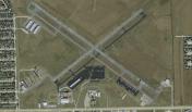
T41
La Porte Municipal Airport
Official FAA Data Effective 2026-01-22 0901Z
Chart Supplement

VFR Chart of T41
Sectional Charts at SkyVector.com
IFR Chart of T41
Enroute Charts at SkyVector.com
Location Information for T41
Coordinates: N29°40.16' / W95°3.85'Located 03 miles NW of La Porte, Texas on 300 acres of land. View all Airports in Texas.
Surveyed Elevation is 25 feet MSL.
Operations Data
|
|
Airport Communications
| AWOS-3PT: | 120.275 Tel. 281-471-2206 |
|---|---|
| HOUSTON APPROACH: | 134.45 284.0 |
| HOUSTON DEPARTURE: | 134.45 284.0 |
| CLEARANCE DELIVERY: | 125.6 |
| CESAN STAR: | 121.3 377.1 |
| TSHRT STAR: | 119.175 291.675 |
| HOODO RNAV DP: | 134.45 284.0 |
| OHIIO STAR: | 120.05 379.1 |
| LURIC RNAV DP: | 284.0 |
| STRYA DP: | 134.45 284.0 |
| WATFO DP: | 134.45 284.0 |
| LURIC DP: | 134.45 |
| HUDZY STAR: | 120.05 379.1 |
| UNICOM: | 122.700 |
| LUFKIN DP: | 134.45 284.0 |
| CTAF: | 122.700 |
| MMALT RNAV DP: | 134.45 284.0 |
| CRIED DP: | 134.45 284.0 |
| BORRN RNAV DP: | 134.45 284.0 |
| ALEXANDRIA DP: | 134.45 284.0 |
| EL DORADO DP: | 134.45 284.0 |
| KARRR RNAV DP: | 134.45 |
| TSHIRT STAR: | 119.175 |
| STYCK DP: | 134.45 284.0 |
| BLTWY RNAV DP: | 134.45 284.0 |
| LEONA DP: | 134.45 284.0 |
| SNDAY RNAV STAR: | 124.225 306.975 |
| GIFFA DP: | 134.45 284.0 |
| WYLSN DP: | 284.0 |
| BLUBELL STAR: | 124.225 306.975 |
| WAPPL STAR: | 120.05 379.1 |
| WYLSN RNAV DP: | 134.45 284.0 |
| INDIE RNAV DP: | 134.45 284.0 |
| TKNIQ STAR: | 119.625 226.675 |
| DREMR DP: | 134.45 284.0 |
| KARRR DP: | 284.0 |
| AWOS-3 at EFD (6.1 SW): | 135.575 713-847-4430 |
| ATIS at EFD (6.2 SW): | 269.9 |
| D-ATIS at HOU (11.2 W): | 124.6 |
Nearby Navigation Aids
|
| ||||||||||||||||||||||||||||||||||||||||||||||||||||||||||||


Runway 12/30
| Dimensions: | 4165 x 75 feet / 1269 x 23 meters | |
|---|---|---|
| Surface: | Asphalt in Fair Condition | |
| Weight Limits: | S-23 | |
| Edge Lighting: | Medium Intensity | |
| Runway 12 | Runway 30 | |
| Coordinates: | N29°40.35' / W95°4.18' | N29°39.95' / W95°3.54' |
| Elevation: | 24.3 | 24.2 |
| Traffic Pattern: | Left | Left |
| Runway Heading: | 126° True | 306° True |
| Displaced Threshold: | 190 Feet | 402 Feet |
| Markings: | Non-Precision Instrument in good condition. | Non-Precision Instrument in good condition. |
| Glide Slope Indicator | P4L (3.00° Glide Path Angle) PAPI RWY 12 UNUSBL BYD 8 DEG L OF RWY CNTRLN. | |
| REIL: | Yes | |
| Obstacles: | 50 ft Trees 1115 ft from runway, 80 ft right of center OBSTN CLNC SLOPE 26:1 TO DSPLCD THLD OVR 30 FT POLES, 927 FT DSTC. |
6 ft Fence 201 ft from runway, 236 ft left of center OBSTN CLNC SLOPE 30:1 TO DSPLCD THLD. 6 FT FENCE 199 FT DSTC 246 FT LEFT OF CNTRLN. |
Runway 05/23
| Dimensions: | 2998 x 75 feet / 914 x 23 meters | |
|---|---|---|
| Surface: | Asphalt in Fair Condition | |
| Weight Limits: | S-25 | |
| Edge Lighting: | Medium Intensity | |
| Runway 05 | Runway 23 | |
| Coordinates: | N29°40.01' / W95°4.07' | N29°40.31' / W95°3.62' |
| Elevation: | 23.2 | 23.7 |
| Traffic Pattern: | Left | Left |
| Runway Heading: | 51° True | 231° True |
| Markings: | Basic in good condition. | Basic in good condition. |
| Obstacles: | 44 ft Pole 915 ft from runway, 215 ft right of center | |
Services Available
| Fuel: | 100LL (blue), Jet-A |
|---|---|
| Transient Storage: | Tiedowns |
| Airframe Repair: | MAJOR |
| Engine Repair: | MAJOR |
| Bottled Oxygen: | NOT AVAILABLE |
| Bulk Oxygen: | NOT AVAILABLE |
| Other Services: | AVIONICS,PILOT INSTRUCTION,AIRCRAFT RENTAL,AIRCRAFT SALES |
Ownership Information
| Ownership: | Publicly owned | |
|---|---|---|
| Owner: | CITY OF LA PORTE | |
| 604 W FAIRMONT PKWY | ||
| LA PORTE, TX 77571 | ||
| 281-471-9650 | ||
| Manager: | RAY MAYO | DIRECTOR OF PUBLIC WORKS. |
| 2963 N 23RD STREET | ||
| LA PORTE, TX 77571 | ||
| 281-471-9650 | ||
Other Remarks
- THIS AIRPORT HAS BEEN SURVEYED BY THE NATIONAL GEODETIC SURVEY.
- FOR CD CTC HOUSTON APCH AT 281-443-5844. TO CNL IFR CTC HOUSTON APCH AT 281-443-5888.
- 0LL FUEL 24 HR SELF SERVE.
- ACTVT REIL RWY 12; PAPI RWY 12; MIRL RWYS 05/23 & 12/30 - CTAF.
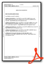
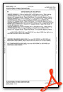
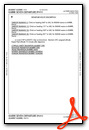
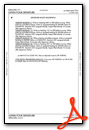
Weather Minimums

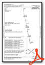
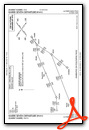
Standard Terminal Arrival (STAR) Charts


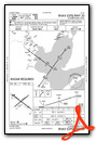
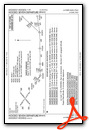
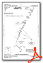
Instrument Approach Procedure (IAP) Charts
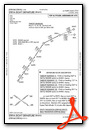
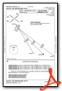
Departure Procedure (DP) Charts
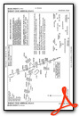
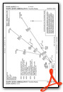
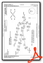
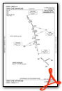
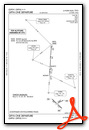
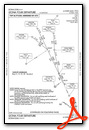
- ALEXANDRIA THREE

- ALEXANDRIA THREE, CONT.1
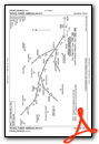
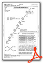
- BLTWY SEVEN (RNAV)
- BORRN SIX (RNAV)
- BORRN SIX (RNAV), CONT.1

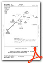
- CRIED ONE
- CRIED ONE, CONT.1
- EL DORADO ONE

- EL DORADO ONE, CONT.1
- GIFFA ONE
- GIFFA ONE, CONT.1

- HOODO SEVEN (RNAV)
- INDIE EIGHT (RNAV)

- KARRR SEVEN (RNAV)
- KARRR SEVEN (RNAV), CONT.1
- LEONA FOUR
- LEONA FOUR, CONT.1

- LUFKIN FOUR
- LUFKIN FOUR, CONT.1
- LURIC EIGHT (RNAV)
- MMALT SEVEN (RNAV)

- STRYA EIGHT (RNAV)
- STYCK EIGHT (RNAV)

- WATFO SIX (RNAV)
- WYLSN EIGHT (RNAV)

Nearby Airports with Instrument Procedures
| ID | Name | Heading / Distance | ||
|---|---|---|---|---|
 |
KEFD | Ellington Airport | 233° | 6.2 |
|
KHPY | Baytown Airport | 039° | 9.1 |
|
KHOU | William P Hobby Airport | 262° | 11.2 |
|
54T | Rwj Airpark Airport | 063° | 12.6 |
|
KLVJ | Pearland Regional Airport | 226° | 12.8 |
|
T00 | Chambers County Airport | 073° | 21.8 |
|
KAXH | Houston/Southwest Airport | 245° | 23.7 |
|
KIAH | George Bush Intcntl/Houston Airport | 322° | 23.8 |
|
KGLS | Scholes International At Galveston Airport | 156° | 26.4 |
|
KSGR | Sugar Land Regional Airport | 264° | 31.1 |
|
T78 | Liberty Municipal Airport | 037° | 31.0 |
|
KIWS | West Houston Airport | 285° | 33.0 |
Airport Images
By: flakeyswilson


