Login
Register


T78
Liberty Municipal Airport
Official FAA Data Effective 2026-02-19 0901Z
Chart Supplement

VFR Chart of T78
Sectional Charts at SkyVector.com
IFR Chart of T78
Enroute Charts at SkyVector.com
Location Information for T78
Coordinates: N30°4.67' / W94°41.91'Located 05 miles E of Liberty, Texas on 127 acres of land. View all Airports in Texas.
Surveyed Elevation is 69 feet MSL.
Operations Data
|
|
Airport Communications
| AWOS-3PT: | 120.775 Tel. 936-587-4150 |
|---|---|
| HOUSTON APPROACH: | 119.7 281.4 |
| HOUSTON DEPARTURE: | 119.7 281.4 |
| BLTWY RNAV DP: | 119.7 281.4 |
| DREMR DP: | 119.7 281.4 |
| BORRN RNAV DP: | 119.7 281.4 |
| KARRR RNAV DP: | 119.7 |
| RIICE STAR: | 124.35 316.15 |
| CTAF: | 122.900 |
| KARR RNAV DP: | 281.4 |
| HUDZY STAR: | 120.05 379.1 |
| WYLSN RNAV DP: | 119.7 281.4 |
| STRYA DP: | 119.7 281.4 |
| STYCK DP: | 119.7 281.4 |
| HOODO RNAV DP: | 119.7 281.4 |
| PIEGY RNAV STAR: | 119.7 281.4 |
| WATFO DP: | 119.7 281.4 |
| INDIE RNAV DP: | 119.7 281.4 |
| LURIC RNAV DP: | 119.7 281.4 |
| MMALT RNAV DP: | 119.7 281.4 |
| AWOS-3 at 6R3 (23.2 NW): | 119.325 281-593-1754 |
| AWOS-3PT at BMT (25.1 E): | 118.425 409-866-2832 |
| AWOS-3PT at T41 (31.0 SW): | 120.275 281-471-2206 |
Nearby Navigation Aids
|
| ||||||||||||||||||||||||||||||||||||||||||||||||||||||||||||


Runway 16/34
| Dimensions: | 3801 x 75 feet / 1159 x 23 meters | |
|---|---|---|
| Surface: | Asphalt in Good Condition | |
| Weight Limits: | S-10 | |
| Edge Lighting: | Medium Intensity | |
| Runway 16 | Runway 34 | |
| Coordinates: | N30°4.97' / W94°42.00' | N30°4.36' / W94°41.82' |
| Elevation: | 68.9 | 68.6 |
| Traffic Pattern: | Left | Left |
| Runway Heading: | 166° True | 346° True |
| Markings: | Non-Precision Instrument in good condition. | Non-Precision Instrument in good condition. |
| Glide Slope Indicator | P2L (3.00° Glide Path Angle) | |
| Obstacles: | 31 ft Trees 201 ft from runway, 182 ft right of center OBSTN EXCEEDS 45 DEG ANGLE. 31 FT TREES, 0-199 FT DSTC, 182 FT R. |
65 ft Trees 1250 ft from runway, 150 ft right of center |
Services Available
| Fuel: | 100LL (blue), Jet-A |
|---|---|
| Transient Storage: | Tiedowns |
| Airframe Repair: | MAJOR |
| Engine Repair: | MAJOR |
| Bottled Oxygen: | NONE |
| Bulk Oxygen: | NONE |
Ownership Information
| Ownership: | Publicly owned | |
|---|---|---|
| Owner: | CITY OF LIBERTY | |
| 1829 SAM HOUSTON | ||
| LIBERTY, TX 77575 | ||
| 936-336-3684 | ||
| Manager: | MARK BUSH | |
| 1829 SAM HOUSTON | ||
| LIBERTY, TX 77575 | ||
| 936-352-1048 | ||
Other Remarks
- THIS AIRPORT HAS BEEN SURVEYED BY THE NATIONAL GEODETIC SURVEY.
- FOR CD CTC HOUSTON APCH AT 281-443-5844 TO CNL IFR CALL 281-443-5888.
- 0LL 24 HR SELF-SVC FUEL.
- ACTVT MIRL RWY 16/34 - CTAF.
Weather Minimums

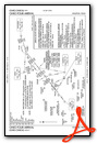
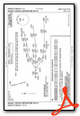
Standard Terminal Arrival (STAR) Charts

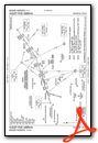


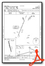
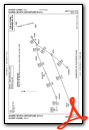
Instrument Approach Procedure (IAP) Charts

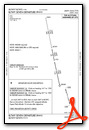
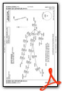
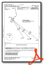
Departure Procedure (DP) Charts


Nearby Airports with Instrument Procedures
| ID | Name | Heading / Distance | ||
|---|---|---|---|---|
 |
T00 | Chambers County Airport | 174° | 18.5 |
|
54T | Rwj Airpark Airport | 202° | 20.5 |
|
T90 | Chambers County/Winnie Stowell Airport | 137° | 20.8 |
|
KHPY | Baytown Airport | 217° | 21.9 |
|
6R3 | Cleveland Municipal Airport | 316° | 23.2 |
|
KBMT | Beaumont Municipal Airport | 090° | 25.2 |
|
45R | Hawthorne Field Airport | 055° | 27.7 |
|
T41 | La Porte Municipal Airport | 218° | 31.0 |
|
KIAH | George Bush Intcntl/Houston Airport | 260° | 33.9 |
|
KBPT | Jack Brooks Regional Airport | 101° | 36.1 |
|
KEFD | Ellington Airport | 220° | 37.0 |
|
KHOU | William P Hobby Airport | 229° | 39.7 |
Airport Images
Do you have a recent image of this airport? Upload it here!


