Login
Register


TFFR
Pointe A Pitre Le Raizet Airport
VFR Chart of TFFR
Sectional Charts at SkyVector.com
IFR Chart of TFFR
Enroute Charts at SkyVector.com
Location Information for TFFR
Coordinates: N16°15.85' / W61°31.55'View all Airports in Pointe-à-Pitre, Guadeloupe.
Elevation is 35.0 feet MSL.
Operations Data
|
|
Airport Communications
| RAIZET APPROACH Approach: | 119.05 |
|---|---|
| RAIZET APPROACH Approach: | 121.30 |
| RAIZET ATIS: | 127.60 |
| RAIZET INFORMATION Information: | 129.80 |
| RAIZET TOWER Tower: | 118.40 |
| RAIZET PREFLIGHT Tower: | 121.85 |
Nearby Navigation Aids
|
| ||||||||||||||||||||||||||||||||||||||||||||||||||||||||||||


Runway 12/30
| Dimensions: | 10266 x 148 feet / 3129 x 45 meters | |
|---|---|---|
| Surface: | Hard | |
| Runway 12 | Runway 30 | |
| Coordinates: | N16°16.06' / W61°32.65' | N16°15.79' / W61°31.24' |
| Elevation: | 5 | 28 |
| Runway Heading: | 116° | 296° |
| Displaced Threshold: | 886 Feet | 984 Feet |
Nearby Airports with Instrument Procedures
| ID | Name | Heading / Distance | ||
|---|---|---|---|---|
 |
TFFS | Les Saintes Terre De Haut Airport | 187° | 24.1 |
|
TFFM | Marie Galante Airport | 148° | 27.8 |
|
TDPD | Roseau/Douglas Charles - International Airport | 163° | 44.8 |
|
TAPA | St. John's/V.C. Bird - International Airport | 343° | 54.3 |
|
TKPN | Charlestown/Vance W. Amory Airport | 312° | 83.2 |
|
TKPK | Basseterre/Robert L. Bradshaw Airport | 312° | 92.9 |
|
TFFF | Martinique Aime Cesaire Airport | 162° | 104.5 |
|
TNCE | F D Roosevelt Airport | 311° | 111.4 |
|
TNCM | Princess Juliana International Airport | 319° | 139.8 |
|
TQPF | Clayton J Lloyd International Airport | 323° | 145.4 |
Airport Images
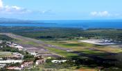
By: BenClosterman

By: Ludovic AGASTIN


