Login
Register


TFFF
Martinique Aime Cesaire Airport
VFR Chart of TFFF
Sectional Charts at SkyVector.com
IFR Chart of TFFF
Enroute Charts at SkyVector.com
Location Information for TFFF
Coordinates: N14°35.53' / W60°59.78'View all Airports in Fort-de-France, Martinique.
Elevation is 16.0 feet MSL.
Operations Data
|
|
Airport Communications
| MARTINIQUE APPROCHE Approach: | 121.00 |
|---|---|
| MARTINIQUE APPROCHE Approach: | 129.05 |
| MARTINIQUE ATIS: | 127.85 |
| MARTINIQUE TOUR Tower: | 118.50 |
| MARTINIQUE PREVOL Tower: | 121.90 |
Nearby Navigation Aids
|
| ||||||||||||||||||||||||||||||||||||||||||||||||||||||||||||


Runway 10/28
| Dimensions: | 9843 x 148 feet / 3000 x 45 meters | |
|---|---|---|
| Surface: | Hard | |
| Runway 10 | Runway 28 | |
| Coordinates: | N14°35.31' / W61°1.10' | N14°35.57' / W60°59.59' |
| Elevation: | 10 | 12 |
| Runway Heading: | 095° | 275° |
| Displaced Threshold: | 820 Feet | |
Nearby Airports with Instrument Procedures
| ID | Name | Heading / Distance | ||
|---|---|---|---|---|
 |
TLPC | George F L Charles Airport | 179° | 34.2 |
|
TLPL | Vieuxfort/ Hewanorra - International Airport | 177° | 51.4 |
|
TDPD | Roseau/Douglas Charles - International Airport | 342° | 59.7 |
|
TFFM | Marie Galante Airport | 348° | 77.9 |
|
TFFS | Les Saintes Terre De Haut Airport | 336° | 83.2 |
|
TVSA | Kingstown/Argyle Airport | 185° | 86.0 |
|
TFFR | Pointe A Pitre Le Raizet Airport | 342° | 104.5 |
|
TVSC | Canouan/Canouan Island Airport | 190° | 114.8 |
|
TBPB | Grantley Adams International Airport | 135° | 126.2 |
Airport Images
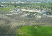
By: Ludovic AGASTIN


