Login
Register


TLPL
Vieuxfort/ Hewanorra - International Airport
VFR Chart of TLPL
Sectional Charts at SkyVector.com
IFR Chart of TLPL
Enroute Charts at SkyVector.com
Location Information for TLPL
Coordinates: N13°43.93' / W60°57.12'View all Airports in Vieux Fort, Saint Lucia.
Elevation is 14.0 feet MSL.
Operations Data
|
|
Airport Communications
| SAINT LUCIA APPROACH Approach: | 119.80 |
|---|---|
| HEWANORRA INTERNATIONAL A ATIS: | 126.15 |
| HEWANORRA TOWER Emergency: | 121.50 |
| HEWANORRA GROUND Ground Control: | 121.60 |
| HEWANORRA TOWER Tower: | 118.30 |
Nearby Navigation Aids
|
| ||||||||||||||||||||||||||||||||||||||||||||||||||||||||||||


Runway 10/28
| Dimensions: | 9003 x 151 feet / 2744 x 46 meters | |
|---|---|---|
| Surface: | Hard | |
| Runway 10 | Runway 28 | |
| Coordinates: | N13°44.00' / W60°57.93' | N13°44.00' / W60°56.49' |
| Elevation: | 10 | 10 |
| Runway Heading: | 105° | 285° |
| Displaced Threshold: | 499 Feet | |
Nearby Airports with Instrument Procedures
| ID | Name | Heading / Distance | ||
|---|---|---|---|---|
 |
TLPC | George F L Charles Airport | 352° | 17.4 |
|
TVSA | Kingstown/Argyle Airport | 198° | 36.1 |
|
TFFF | Martinique Aime Cesaire Airport | 357° | 51.4 |
|
TVSC | Canouan/Canouan Island Airport | 200° | 65.8 |
|
TBPB | Grantley Adams International Airport | 114° | 94.0 |
|
TDPD | Roseau/Douglas Charles - International Airport | 349° | 110.3 |
|
TGPY | St. Georges/Maurice Bishop - I Airport | 205° | 114.2 |
Airport Images
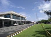
By: Jaid167


