Login
Register
TNP
Twentynine Palms Airport
Official FAA Data Effective 2026-01-22 0901Z
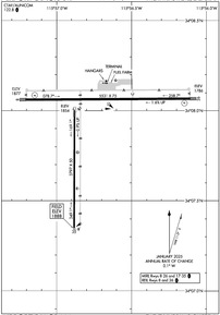
VFR Chart of KTNP
Sectional Charts at SkyVector.com
IFR Chart of KTNP
Enroute Charts at SkyVector.com
Location Information for KTNP
Coordinates: N34°7.89' / W115°56.75'Located 06 miles E of Twentynine Palms, California on 480 acres of land. View all Airports in California.
Surveyed Elevation is 1888 feet MSL.
Operations Data
|
|
Airport Communications
| UNICOM: | 122.800 |
|---|---|
| CTAF: | 122.800 |
| ASOS at NXP (14.6 NW): | 309.75 760-830-8146 |
| ASOS at TRM (31.9 S): | 118.325 760-399-1494 |
| ATIS at PSP (33.3 SW): | 124.65 |
- APCH/DEP CTL SVC PRVDD BY LOS ANGELES ARTCC (ZLA) ON FREQS 128.15/285.6 (TWENTYNINE PALMS RCAG).
Nearby Navigation Aids
|
| ||||||||||||||||||||||||||||||||||||||||||
Runway 08/26
| Dimensions: | 5531 x 75 feet / 1686 x 23 meters | |
|---|---|---|
| Surface: | Asphalt in Fair Condition | |
| Edge Lighting: | Medium Intensity | |
| Runway 08 | Runway 26 | |
| Coordinates: | N34°8.06' / W115°57.21' | N34°8.07' / W115°56.11' |
| Elevation: | 1876.6 | 1786.4 |
| Traffic Pattern: | Left | Left |
| Runway Heading: | 90° True | 270° True |
| Markings: | Basic in good condition. | Non-Precision Instrument in good condition. |
| Glide Slope Indicator | P2L (3.00° Glide Path Angle) | P2L (3.00° Glide Path Angle) |
| REIL: | Yes | Yes |
| Obstacles: | 120 ft Power Line 4100 ft from runway | |
Runway 17/35
| Dimensions: | 3797 x 50 feet / 1157 x 15 meters | |
|---|---|---|
| Surface: | Asphalt in Fair Condition | |
| Edge Lighting: | Medium Intensity | |
| Runway 17 | Runway 35 | |
| Coordinates: | N34°7.96' / W115°56.88' | N34°7.34' / W115°56.88' |
| Elevation: | 1853.5 | 1888.0 |
| Traffic Pattern: | Left | Left |
| Runway Heading: | 180° True | 0 |
| Markings: | Basic in good condition. | Basic in good condition. |
| Obstacles: | 30 ft Power Line 1400 ft from runway PLINES |
200 ft Hill 3300 ft from runway +2 FT TERRAIN AT 200 FT FROM THLD. |
Services Available
| Fuel: | 100LL (blue) |
|---|---|
| Transient Storage: | Tiedowns |
| Airframe Repair: | MINOR |
| Engine Repair: | MINOR |
| Bottled Oxygen: | NONE |
| Bulk Oxygen: | NONE |
| Other Services: | CHARTER SERVICE,PILOT INSTRUCTION,AIRCRAFT RENTAL,GLIDER TOWING SERVICES |
Ownership Information
| Ownership: | Publicly owned | |
|---|---|---|
| Owner: | COUNTY OF SAN BERNARDINO | |
| 777 EAST RIALTO AVENUE | ||
| SAN BERNARDINO, CA 92415 | ||
| 909-387-8810 | ||
| Manager: | MAUREEN A. SNELGROVE | |
| 777 E. RIALTO AVE. | ||
| SAN BERNARDINO, CA 92415 | ||
| 909-387-8810 | ||
Other Remarks
- THIS AIRPORT HAS BEEN SURVEYED BY THE NATIONAL GEODETIC SURVEY.
- TWY LGTS ON TWY CONNECTING RWY 08/26 & RWY 17/35; PLUS BLUE REFLECTORS ON PARALLEL TWY SERVING RWY 17/35.
- BE ALERT FOR AEROBATIC ACTIVITY SOUTH OF RY 17/35.
- FOR CD IF UNA TO CTC ON FSS FREQ, CTC LOS ANGELES ARTCC AT 661-575-2079.
- 0LL 100LL AVBL 24 HRS.
- ACTVT MIRL RY 08/26 AND 17/35; REIL RY 08 AND RY 26 - CTAF.
- AUTOMATED UNICOM.
Weather Minimums
Instrument Approach Procedure (IAP) Charts
Nearby Airports with Instrument Procedures
| ID | Name | Heading / Distance | ||
|---|---|---|---|---|
 |
KUDD | Bermuda Dunes Airport | 215° | 28.2 |
 |
KTRM | Jacqueline Cochran Regional Airport | 199° | 32.1 |
 |
KPSP | Palm Springs International Airport | 237° | 33.3 |
 |
L35 | Big Bear City Airport | 280° | 46.0 |
 |
L08 | Borrego Valley Airport | 199° | 55.5 |
 |
KHMT | Hemet-Ryan Airport | 246° | 58.8 |
 |
KREI | Redlands Municipal Airport | 267° | 59.9 |
 |
KDAG | Barstow-Daggett Airport | 316° | 60.1 |
 |
KCLR | Cliff Hatfield Memorial Airport | 160° | 63.6 |
 |
KSBD | San Bernardino International Airport | 268° | 64.3 |
 |
KAPV | Apple Valley Airport | 293° | 67.1 |
 |
KRIV | March Arb Airport | 257° | 67.2 |


Comments
Fuel Prices
Fuel at KTNP is currently (as of 01/19/15) at $4.20/gal (100LL) mastercard or visa.