Login
Register


U10
Preston Airport
Official FAA Data Effective 2026-02-19 0901Z
Chart Supplement

VFR Chart of U10
Sectional Charts at SkyVector.com
IFR Chart of U10
Enroute Charts at SkyVector.com
Location Information for U10
Coordinates: N42°6.42' / W111°54.75'Located 02 miles NW of Preston, Idaho on 142 acres of land. View all Airports in Idaho.
Surveyed Elevation is 4727 feet MSL.
Operations Data
|
|
Airport Communications
| CTAF: | 122.800 |
|---|---|
| UNICOM: | 122.800 |
| ASOS at LGU (19.4 S): | 135.275 435-752-6941 |
| AWOS-3 at 1U7 (27.3 E): | 118.525 208 847 0613 |
| AWOS-3 at BMC (33.8 S): | 135.075 435-723-3852 |
Nearby Navigation Aids
|
| ||||||||||||||||||||||||||||||||||||


Runway 04/22
| Dimensions: | 3557 x 60 feet / 1084 x 18 meters | |
|---|---|---|
| Surface: | Asphalt in Good Condition | |
| Weight Limits: | S-12 | |
| Edge Lighting: | Medium Intensity | |
| Runway 04 | Runway 22 | |
| Coordinates: | N42°6.25' / W111°55.02' | N42°6.64' / W111°54.44' |
| Elevation: | 4725.0 | 4724.1 |
| Traffic Pattern: | Left | Left |
| Runway Heading: | 48° True | 228° True |
| Displaced Threshold: | 384 Feet DSPLCD THR MKD WITH DSPLCD THR BAR ONLY. |
|
| Markings: | Basic in good condition. | Basic in good condition. |
| Glide Slope Indicator | P2L (3.00° Glide Path Angle) | P2L (3.00° Glide Path Angle) UNUSBL BYD 4.0 NM FM THR AND DOES NOT PRVD OBSTN CLNC. |
| REIL: | Yes | |
| Obstacles: | 17 ft Road 200 ft from runway, 70 ft right of center APCH SLOPE 31:1 TO DSPLCD THR. +4' FENCE AT 100', 75' RIGHT. |
|
Runway 17/35
| Dimensions: | 2375 x 30 feet / 724 x 9 meters | |
|---|---|---|
| Surface: | Gravel-Dirt in Good Condition GRVL SFC USED BY CROP DUSTERS. | |
| Runway 17 | Runway 35 | |
| Coordinates: | N42°6.57' / W111°54.80' | N42°6.18' / W111°54.79' |
| Elevation: | 4727.7 | 4727.5 |
| Traffic Pattern: | Left | Left |
| Runway Heading: | 179° True | 359° True |
| Markings: | in fair condition. | in fair condition. |
Services Available
| Fuel: | 100LL (blue) |
|---|---|
| Transient Storage: | Tiedowns |
| Airframe Repair: | MINOR |
| Engine Repair: | MINOR |
| Bottled Oxygen: | NONE |
| Bulk Oxygen: | NONE |
| Other Services: | CROP DUSTING SERVICES,PILOT INSTRUCTION |
Ownership Information
| Ownership: | Publicly owned | |
|---|---|---|
| Owner: | CITY OF PRESTON & FRANKLIN CO | |
| 70 WEST ONEIDA | CITY OF PRESTON'S ADDRESS AND TEL NUMBER. | |
| PRESTON, ID 83263 | ||
| 208-852-1817 | ||
| Manager: | CRAIG BIGGS | |
| 1319 W 800 NORTH | ||
| PRESTON, ID 83263 | ||
| 208-852-2151 | ||
Other Remarks
- LCTD ON PLATEAU. SHARP DROPOFF NEAR THR RWYS 04, 17 & 35.
- RWY 17/35 CLSD WINTER.
- FOR CD CTC SALT LAKE ARTCC AT 801-320-2568.
- ACTVT REIL RWY 04: MIRL RWY 04/22 - CTAF. PAPI RWY 04 & RWY 22 OPR CONSLY.
Nearby Airports with Instrument Procedures
| ID | Name | Heading / Distance | ||
|---|---|---|---|---|
 |
KLGU | Logan-Cache Airport | 171° | 19.1 |
|
1U7 | Bear Lake County Airport | 071° | 26.9 |
|
KBMC | Brigham City Regional Airport | 191° | 33.8 |
|
KOGD | Ogden-Hinckley Airport | 184° | 54.9 |
|
KAFO | Afton Lincoln County/General Boyd L Eddins Field Airport | 049° | 56.2 |
|
KPIH | Pocatello Regional Airport | 328° | 56.9 |
|
KHIF | Hill AFB Airport | 182° | 59.0 |
|
KEMM | Kemmerer Municipal Airport | 105° | 63.0 |
|
KEVW | Evanston-Uinta County Burns Field Airport | 141° | 63.6 |
|
U02 | Mccarley Field Airport | 343° | 68.9 |
|
KSLC | Salt Lake City International Airport | 182° | 79.1 |
|
KFBR | Fort Bridger Airport | 121° | 80.1 |
Airport Images
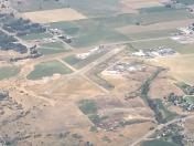
By: jbellwoo

By: timmonst@cox.net


