Login
Register


VNC
Venice Municipal Airport
Official FAA Data Effective 2026-02-19 0901Z
Chart Supplement

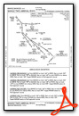
KVNC Airport Diagram

VFR Chart of KVNC
Sectional Charts at SkyVector.com
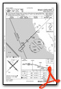
IFR Chart of KVNC
Enroute Charts at SkyVector.com
Location Information for KVNC
Coordinates: N27°4.28' / W82°26.40'Located 02 miles S of Venice, Florida on 835 acres of land. View all Airports in Florida.
Surveyed Elevation is 18 feet MSL.
Operations Data
|
|
Airport Communications
| AWOS-3: | 119.275 Tel. 941-486-2718 |
|---|---|
| TAMPA APPROACH: | 119.65 124.95 353.575 |
| TAMPA DEPARTURE: | 119.65 124.95 353.575 |
| CLEARANCE DELIVERY: | 118.075 |
| UNICOM: | 122.725 |
| RAYZZ STAR: | 118.8 239.3 |
| CTAF: | 122.725 |
| BANGZ STAR: | 118.8 239.3 |
| LUBBR STAR: | 135.5 279.6 |
| AWOS-3PT at 54A (16.4 SE): | 120.00 941-725-0701 |
| ATIS at SRQ (20.4 N): | 124.375 |
| ASOS at SRQ (20.4 N): | 124.375 941-355-8482 |
Nearby Navigation Aids
|
| ||||||||||||||||||||||||||||||||||||||||||||||||


Runway 13/31
| Dimensions: | 5640 x 150 feet / 1719 x 46 meters | |
|---|---|---|
| Surface: | Asphalt in Excellent Condition | |
| Weight Limits: | 26 /F/A/X/T, S-75, D-108 | |
| Edge Lighting: | Medium Intensity | |
| Runway 13 | Runway 31 | |
| Coordinates: | N27°4.57' / W82°26.81' | N27°3.91' / W82°26.08' |
| Elevation: | 14.9 | 16.3 |
| Traffic Pattern: | Right | Left |
| Runway Heading: | 135° True | 315° True |
| Displaced Threshold: | 639 Feet | 639 Feet |
| Declared Distances: | TORA:5000 TODA:5000 ASDA:5000 LDA:5000 | TORA:5000 TODA:5000 ASDA:5000 LDA:5000 |
| Markings: | Non-Precision Instrument in good condition. | Non-Precision Instrument in good condition. |
| Glide Slope Indicator | P4L (3.00° Glide Path Angle) | P4L (3.00° Glide Path Angle) |
| REIL: | Yes | Yes |
| Obstacles: | 40 ft Trees 1155 ft from runway, 255 ft right of center RWY 13 APCH SLOPE 45:1 TO DTHR. |
45 ft Tree 890 ft from runway, 110 ft right of center RWY 31 APCH SLOPE 34:1 TO DTHR. |
Runway 05/23
| Dimensions: | 5000 x 150 feet / 1524 x 46 meters | |
|---|---|---|
| Surface: | Asphalt in Good Condition | |
| Weight Limits: | 26 /F/A/X/T, S-75, D-108 | |
| Edge Lighting: | Medium Intensity | |
| Runway 05 | Runway 23 | |
| Coordinates: | N27°4.03' / W82°26.68' | N27°4.61' / W82°26.02' |
| Elevation: | 12.4 | 17.4 |
| Traffic Pattern: | Left | Left |
| Runway Heading: | 45° True | 225° True |
| Displaced Threshold: | 463 Feet | |
| Declared Distances: | TORA:5000 TODA:5000 ASDA:4840 LDA:4377 | |
| Markings: | Non-Precision Instrument in good condition. | Non-Precision Instrument in good condition. |
| Glide Slope Indicator | P4L (3.00° Glide Path Angle) | P4L (3.00° Glide Path Angle) |
| REIL: | Yes | Yes |
| Obstacles: | 14 ft Trees 865 ft from runway, 225 ft left of center | 55 ft Bridge 1190 ft from runway, 90 ft left of center RWY 23 APCH RATIO 30:1 TO DTHR. |
Services Available
| Fuel: | 100LL (blue), Jet-A |
|---|---|
| Transient Storage: | Hangars,Tiedowns |
| Airframe Repair: | MAJOR |
| Engine Repair: | MAJOR |
| Bottled Oxygen: | NONE |
| Bulk Oxygen: | NONE |
| Other Services: | AVIONICS,CHARTER SERVICE,PILOT INSTRUCTION,AIRCRAFT RENTAL,AIRCRAFT SALES |
Ownership Information
| Ownership: | Publicly owned | |
|---|---|---|
| Owner: | CITY OF VENICE | |
| 401 WEST VENICE AVE | ||
| VENICE, FL 34285 | ||
| 941-486-2626 | ||
| Manager: | NICHOLAS DUMAS | |
| 150 AIRPORT AVE EAST | ||
| VENICE, FL 34285 | ||
| 941-486-2711 | ||
Other Remarks
- NOISE ABATEMENT PROCEDURES IN EFFECT, CALL AMGR 941-486-2711.
- ARPT SFC CONDS NOT RPRTD.
- FOR CD CTC TAMPA APCH AT 813-878-2528
- 24 HR PPR FOR ACFT EQUIPPED WITH WEATHER MODIFICATION OR GEOENGINEERING EQPT 941-486-2711.
- ARPT HAS EXTENSIVE FLIGHT TRAINING.
- BIRD AND WILDLIFE ON AND INVOF THE ARPT.
- PAEW ADJ TO ALL RYS AND TWYS DURG DALGT HRS.
- PPR FOR ACFT EXCEEDING RY WEIGHT BEARING CAPACITY.
- PARASAILING ACTIVITY WEST THE ARPT ALONG BEACH.
- RY 23 IS CALM WIND RY.
- RWY 05/23 PREF APCH.
- PREF DEP CALM WIND RWY.
- ACTVT REIL RWY 5, 23, & 13; MIRL RWY 5/23, 13/31 - CTAF.
- ENGINEERED MATERIAL ARRESTING SYSTEM 260 FT IN LENGTH BY 165 FT IN WIDTH LCTD AT THE DER 13.
Weather Minimums

Standard Terminal Arrival (STAR) Charts


Instrument Approach Procedure (IAP) Charts


Departure Procedure (DP) Charts


Nearby Airports with Instrument Procedures
| ID | Name | Heading / Distance | ||
|---|---|---|---|---|
 |
FA54 | Coral Creek Airport | 142° | 16.4 |
|
KSRQ | Sarasota/Bradenton International Airport | 342° | 20.3 |
|
KPGD | Punta Gorda Airport | 110° | 25.7 |
|
X06 | Arcadia Municipal Airport | 076° | 33.1 |
|
KCHN | Wauchula Municipal Airport | 048° | 40.0 |
|
KFMY | Page Field Airport | 132° | 42.4 |
|
KSPG | Albert Whitted Airport | 346° | 42.7 |
|
KMCF | Macdill AFB Airport | 354° | 46.8 |
|
KRSW | Southwest Florida International Airport | 130° | 48.8 |
|
KTPF | Peter O Knight Airport | 359° | 50.5 |
|
KPIE | St Pete-Clearwater International Airport | 345° | 51.8 |
|
KTPA | Tampa International Airport | 354° | 54.3 |


