Login
Register
L45
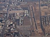
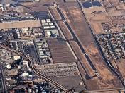
Bakersfield Municipal Airport
Official FAA Data Effective 2024-12-26 0901Z
VFR Chart of L45
Sectional Charts at SkyVector.com
IFR Chart of L45
Enroute Charts at SkyVector.com
Location Information for L45
Coordinates: N35°19.49' / W118°59.76'Located 03 miles S of Bakersfield, California on 253 acres of land. View all Airports in California.
Surveyed Elevation is 378 feet MSL.
Operations Data
|
|
Airport Communications
| BAKERSFIELD APPROACH: | 126.45 270.3 |
|---|---|
| BAKERSFIELD DEPARTURE: | 126.45 270.3 |
| CTAF: | 122.800 |
| UNICOM: | 122.800 |
| ASOS at BFL (7.2 NW): | 661-393-3766 |
| ATIS at BFL (7.2 NW): | 118.6 |
| AWOS-3 at MIT (14.5 NW): | 121.125 661-393-8596 |
- APCH/DEP CTL SVC PRVDD BY LOS ANGELES ARTCC ARTCC (ZLA) ON FREQS 127.1/317.7 (BAKERSFIELD RCAG) WHEN BAKERSFIELD APCH CTL (BFL) CLSD.
Nearby Navigation Aids
|
| ||||||||||||||||||||||||||||||||||||||||||
Runway 16/34
| Dimensions: | 4000 x 75 feet / 1219 x 23 meters 150 FT PAVED STOPWAY AT EACH END OF RWY. | |
|---|---|---|
| Surface: | Asphalt in Good Condition | |
| Weight Limits: | S-20 | |
| Edge Lighting: | Medium Intensity | |
| Runway 16 | Runway 34 | |
| Coordinates: | N35°19.82' / W118°59.80' | N35°19.16' / W118°59.72' |
| Elevation: | 378.3 | 372.3 |
| Traffic Pattern: | Right | |
| Runway Heading: | 175° True | 355° True |
| Markings: | Non-Precision Instrument in good condition. | Non-Precision Instrument in good condition. |
| Glide Slope Indicator | P2L (4.10° Glide Path Angle) | |
| REIL: | Yes | Yes |
| Obstacles: | 15 ft Road 650 ft from runway, 170 ft left of center | 103 ft Power Line 2500 ft from runway |
Services Available
| Fuel: | 100LL (blue), Jet-A |
|---|---|
| Transient Storage: | Tiedowns |
| Airframe Repair: | MAJOR |
| Engine Repair: | MAJOR |
| Bottled Oxygen: | NOT AVAILABLE |
| Bulk Oxygen: | NOT AVAILABLE |
| Other Services: | CHARTER SERVICE,PILOT INSTRUCTION,AIRCRAFT RENTAL |
Ownership Information
| Ownership: | Publicly owned | |
|---|---|---|
| Owner: | CITY OF BAKERSFIELD | |
| 1501 TRUXTUN AVE | ||
| BAKERSFIELD, CA 93301 | ||
| 661-326-3781 | ||
| Manager: | KEVIN PEOPLES | |
| 4101 TRUXTUN AVENUE | ||
| BAKERSFIELD, CA 93309 | ||
| 661-326-3781 | EMERGENCY 661-327-7111 | |
Other Remarks
- +100 FT POLE LINE 1/2 MILE SOUTH OF ARPT.
- (E98) ALSO ONE HEX HANGER & 20 OPEN - SHADE HANGARS.
- FOR CD CTC LOS ANGELES ARTCC AT 661-575-2079.
- FULL SERVICE USING FUELING TRUCK.
- ACTVT REIL RWY 16 AND RWY 34; MIRL RWY 16/34 - CTAF. PAPI RWY 34 OPER CONSLY. ACTVT MIRL RWY 16/34 THREE CLICKS FOR ON; LGTS GO OUT AFTER 15 MINS.
Weather Minimums
Instrument Approach Procedure (IAP) Charts
Departure Procedure (DP) Charts
Nearby Airports with Instrument Procedures
| ID | Name | Heading / Distance | ||
|---|---|---|---|---|
 |
KBFL | Meadows Field Airport | 335° | 7.2 |
 |
KMIT | Shafter-Minter Field Airport | 318° | 14.6 |
 |
KDLO | Delano Municipal Airport | 335° | 27.8 |
 |
KPTV | Porterville Municipal Airport | 355° | 42.3 |
 |
KMHV | Mojave Air & Space Port/Rutan Field Airport | 110° | 44.5 |
 |
L71 | California City Municipal Airport | 101° | 49.2 |
 |
KWJF | General Wm J Fox Airfield Airport | 132° | 51.9 |
 |
KTLR | Mefford Field Airport | 342° | 52.4 |
 |
KEDW | Edwards AFB Airport | 114° | 60.1 |
 |
KIYK | Inyokern Airport | 070° | 60.6 |
 |
KPMD | Palmdale Usaf Plant 42 Airport | 132° | 61.3 |
 |
KVIS | Visalia Municipal Airport | 342° | 62.6 |


Comments
New cafe on the field. 6am
New cafe on the field. 6am to 2pm
Pages