Login
Register
LBSF
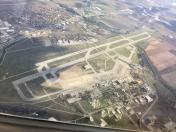
Sofia Airport
VFR Chart of LBSF
Sectional Charts at SkyVector.com
IFR Chart of LBSF
Enroute Charts at SkyVector.com
Location Information for LBSF
Coordinates: N42°41.70' / E23°24.50'View all Airports in Grad Sofiya, Bulgaria.
Elevation is 1742.0 feet MSL.
Operations Data
|
|
Airport Communications
| SOFIA APPROACH Approach: | 123.70 |
|---|---|
| SOFIA Approach: | 129.90 |
| SOFIA ATIS: | 126.68 |
| SOFIA Emergency: | 121.50 |
| SOFIA Tower: | 118.10 |
| SOFIA Tower: | 120.20 |
| SOFIA Tower: | 336.40 |
Nearby Navigation Aids
|
| ||||||||||||||||||||||||||||||||||||||||||||||||||||||||||||
Runway 09/27
| Dimensions: | 11811 x 148 feet / 3600 x 45 meters | |
|---|---|---|
| Surface: | Hard | |
| Runway 09 | Runway 27 | |
| Coordinates: | N42°41.85' / E23°23.97' | N42°41.71' / E23°26.38' |
| Elevation: | 1739 | 1744 |
| Runway Heading: | 089° | 269° |
| Displaced Threshold: | 984 Feet | |
Nearby Airports with Instrument Procedures
| ID | Name | Heading / Distance | ||
|---|---|---|---|---|
 |
LBPD | Plovdiv Airport | 119° | 74.4 |
 |
LYNI | Nis/Konstantin Veliki Airport | 299° | 78.5 |
 |
LWSK | Skopje International Airport | 241° | 90.9 |
 |
LRCV | Craiova Airport | 011° | 99.6 |
 |
LBGO | Gorna Oryahovitsa Airport | 074° | 105.2 |
 |
BKPR | Pristina/International Airport | 266° | 105.3 |
 |
LGKV | Megas Alexandros Airport | 152° | 119.9 |
 |
LAKU | Kukes Airport | 254° | 138.8 |
 |
LYKV | Morava Airport | 299° | 140.9 |
 |
LWOH | Ohrid/St.Paul The Apostle Airport | 233° | 150.0 |
 |
LGAL | Dimokritos Airport | 133° | 158.9 |
 |
LRBS | Baneasa-Aurel Vlaicu Airport | 046° | 159.9 |


Comments
LBSF ATIS Frequency
Correct Frequency is 126.675MHz