Login
Register


0IN4
Air Park Field Airport
Official FAA Data Effective 2026-01-22 0901Z
VFR Chart of 0IN4
Sectional Charts at SkyVector.com
IFR Chart of 0IN4
Enroute Charts at SkyVector.com
Location Information for 0IN4
Coordinates: N41°8.52' / W84°54.54'Located 04 miles NW of Woodburn, Indiana. View all Airports in Indiana.
Estimated Elevation is 750 feet MSL.
Operations Data
|
|
Airport Communications
| AWOS-3 at SMD (11.0 W): | 124.55 260-490-4030 |
|---|---|
| AWOS-3P at GWB (11.8 NW): | 124.15 260-925-8225 |
| ASOS at FWA (16.3 SW): | 121.25 260-209-0224 |
Nearby Navigation Aids
|
| ||||||||||||||||||||||||||||||||||||||||||||||||||||||||||||


Runway 17/35
| Dimensions: | 2274 x 30 feet / 693 x 9 meters | |
|---|---|---|
| Surface: | Asphalt | |
| Runway 17 | Runway 35 | |
| Coordinates: | N41°8.71' / W84°54.57' | N41°8.34' / W84°54.51' |
| Elevation: | 750.0 | 745.0 |
| Traffic Pattern: | Left | Left |
| Runway Heading: | 173° True | 353° True |
| Obstacles: | ft Road ft from runway | |
Ownership Information
| Ownership: | Privately Owned | |
|---|---|---|
| Owner: | LOUIS DELAGRANGE | |
| 132 LINCOLN HWY WEST | ||
| NEW HAVEN, IN 46774 | ||
| 260-632-4811 | ||
| Manager: | LOUIS DELAGRANGE | |
| 132 LINCOLN HWY WEST | ||
| NEW HAVEN, IN 46774 | ||
| 260-632-4811 | ||
Other Remarks
- FOR CD CTC CHICAGO ARTCC AT 630-906-8921.
Nearby Airports with Instrument Procedures
| ID | Name | Heading / Distance | ||
|---|---|---|---|---|
 |
KSMD | Smith Field Airport | 270° | 11.1 |
|
KGWB | Auburn/Dekalb Exec Airport | 325° | 12.0 |
|
KFWA | Fort Wayne International Airport | 233° | 16.3 |
|
KVNW | Van Wert County Airport | 140° | 21.6 |
|
KDFI | Defiance Memorial Airport | 061° | 24.7 |
|
C62 | Kendallville Municipal Airport | 321° | 25.4 |
|
0G6 | Williams County Airport | 042° | 26.7 |
|
KHHG | Huntington Municipal Airport | 235° | 30.3 |
|
KANQ | Tri-State Steuben County Airport | 345° | 30.9 |
|
7W5 | Henry County Airport | 069° | 40.5 |
|
KPLD | Portland Municipal Airport | 185° | 41.6 |
|
KOWX | Putnam County Airport | 098° | 42.5 |
Airport Images
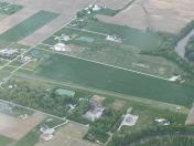
By: Big Orange Bird


