Login
Register


OWX
Putnam County Airport
Official FAA Data Effective 2024-04-18 0901Z
Chart Supplement

VFR Chart of KOWX
Sectional Charts at SkyVector.com
IFR Chart of KOWX
Enroute Charts at SkyVector.com
Location Information for KOWX
Coordinates: N41°2.14' / W83°58.91'Located 03 miles NE of Ottawa, Ohio on 111 acres of land. View all Airports in Ohio.
Surveyed Elevation is 763 feet MSL.
Operations Data
|
|
Airport Communications
| AWOS-3: | 120.525 Tel. 419-523-4151 |
|---|---|
| TOLEDO APPROACH: | 120.8 317.55 |
| TOLEDO DEPARTURE: | 120.8 317.55 |
| CTAF: | 122.700 |
| UNICOM: | 122.700 |
| ASOS at FDY (14.3 E): | 132.85 419-427-8524 |
| ASOS at AOH (19.8 S): | 128.725 419-224-6098 |
| AWOS-3 at 1G0 (26.6 NE): | 120.725 419-354-1415 |
Nearby Navigation Aids
|
| ||||||||||||||||||||||||||||||||||||||||||||||||||||||||||||


Runway 09/27
| Dimensions: | 4502 x 75 feet / 1372 x 23 meters | |
|---|---|---|
| Surface: | Asphalt in Good Condition | |
| Edge Lighting: | Medium Intensity | |
| Runway 09 | Runway 27 | |
| Coordinates: | N41°2.13' / W83°59.40' | N41°2.14' / W83°58.42' |
| Elevation: | 754.1 | 763.5 |
| Traffic Pattern: | Left | Left |
| Runway Heading: | 90° True | 270° True |
| Markings: | Non-Precision Instrument in good condition. | Non-Precision Instrument in good condition. |
| Glide Slope Indicator | P2L (3.00° Glide Path Angle) | P2L (3.00° Glide Path Angle) |
| REIL: | Yes | Yes |
| Obstacles: | 16 ft Road 201 ft from runway, 217 ft left of center +9 FT ROAD, 0-200 FT DIST, 217 FT L. |
11 ft Road 201 ft from runway, 208 ft right of center +11 FT ROAD, 0-200 FT DIST, 208 FT R. |
Services Available
| Fuel: | 100LL (blue), Jet A+ |
|---|---|
| Transient Storage: | Hangars,Tiedowns PRIOR CDN RQRD. |
| Airframe Repair: | NONE |
| Engine Repair: | NONE |
| Bottled Oxygen: | NONE |
| Bulk Oxygen: | NONE |
| Other Services: | CROP DUSTING SERVICES |
Ownership Information
| Ownership: | Publicly owned | |
|---|---|---|
| Owner: | PUTNAM CO ARPT AUTHORITY | |
| 10218 ROAD 5H | ||
| OTTAWA, OH 45875-9715 | ||
| 419-523-3910 | ||
| Manager: | CHAD & LINDA NIESE | |
| 10218 ROAD 5H | ||
| OTTAWA, OH 45875-9715 | ||
| 419-523-3910 | ||
Operational Statistics
| Single Engine Aircraft Based on Field: | 21 | Statistics collected for 12 month period ending 2021-09-14 | |
|---|---|---|---|
| Multi-Engine Aircraft Based on Field: | 2 | Annual Commercial Operations: | none |
| Jet Aircraft Based on Field: | none | Annual Commuter Operations: | none |
| Helicopters Based on Field: | none | Annual Air Taxi Operations: | 10 |
| Military Aircraft Based on Field: | none | Annual Military Operations: | none |
| Gliders Based on Field: | 1 | Annual GA Local Operations: | 9980 |
| Ultralights Based on Field: | none | Annual GA Itinerant Operations: | 3000 |
Other Remarks
- INTENSIVE AGRI OPNS & CROP DUSTING.
- FOR CD CTC TOLEDO APCH AT 419-865-1495.
- 0LL FUEL AVBL H24 SELF SVC.
- ACTVT REIL RWY 09 & 27; MIRL RWY 09/27 - CTAF. PAPI RWY 09 & 27 OPR CONSLY.
Weather Minimums

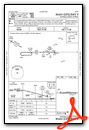
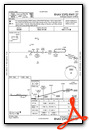
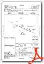
Instrument Approach Procedure (IAP) Charts
Nearby Airports with Instrument Procedures
| ID | Name | Heading / Distance | ||
|---|---|---|---|---|
 |
5G7 | Bluffton Airport | 150° | 10.4 |
|
KFDY | Findlay Airport | 095° | 14.3 |
|
KAOH | Lima Allen County Airport | 185° | 19.8 |
|
7W5 | Henry County Airport | 349° | 20.7 |
|
1G0 | Wood County Airport | 036° | 26.6 |
|
KDFI | Defiance Memorial Airport | 311° | 27.2 |
|
KFZI | Fostoria Metro Airport | 070° | 28.3 |
|
I95 | Hardin County Airport | 148° | 29.8 |
|
KVNW | Van Wert County Airport | 250° | 30.2 |
|
56D | Wyandot County Airport | 106° | 31.7 |
|
KTOL | Eugene F Kranz Toledo Express Airport | 013° | 34.0 |
|
16G | Seneca County Airport | 084° | 35.1 |
Airport Images
Do you have a recent image of this airport? Upload it here!


