Login
Register


18AZ
Sky Ranch At Carefree Airport
Official FAA Data Effective 2026-02-19 0901Z
VFR Chart of 18AZ
Sectional Charts at SkyVector.com
IFR Chart of 18AZ
Enroute Charts at SkyVector.com
Location Information for 18AZ
Coordinates: N33°49.12' / W111°53.89'Located 01 miles E of Carefree, Arizona on 55 acres of land. View all Airports in Arizona.
Estimated Elevation is 2569 feet MSL.
TKOF RWY 6 CLIMB TO 3200 FT BFR TURNING; TKOF RWY 24 CLIMB TO 3000 FT BFR TURNING.
Operations Data
|
|
Airport Communications
| AWOS-1: | 125.625 Tel. 480-488-7882 |
|---|---|
| CTAF: | 122.725 |
| UNICOM: | 122.725 |
| ATIS at SDL (11.8 S): | 118.6 |
| ATIS at DVT (12.1 SW): | 126.5 |
| ASOS at DVT (12.1 SW): | 126.5 623-587-7764 |
Nearby Navigation Aids
|
| ||||||||||||||||||||||||||||||||||||


Runway 06/24
| Dimensions: | 4029 x 50 feet / 1228 x 15 meters | |
|---|---|---|
| Surface: | Asphalt | |
| Weight Limits: | S-12 | |
| Edge Lighting: | Low Intensity | |
| Runway 06 | Runway 24 | |
| Coordinates: | N33°49.01' / W111°54.27' | N33°49.22' / W111°53.51' |
| Elevation: | 2489.0 | 2569.0 |
| Traffic Pattern: | Right | Left |
| Runway Heading: | 71° True | 251° True |
| Displaced Threshold: | 495 Feet | |
| Markings: | Basic in good condition. | Basic in good condition. |
| REIL: | Yes | Yes |
| Obstacles: | 20 ft Cactus 400 ft from runway ROAD 95 FT L; +5 FT SIGN 90 FT L. |
20 ft Brush 200 ft from runway ROAD AT 150 FT; +5 FT TRRN & SIGN 90 FT R. |
Services Available
| Fuel: | 100LL (blue), Jet A+ |
|---|---|
| Transient Storage: | Tiedowns |
| Airframe Repair: | NOT AVAILABLE |
| Engine Repair: | NOT AVAILABLE |
| Bottled Oxygen: | NOT AVAILABLE |
| Bulk Oxygen: | NOT AVAILABLE |
Ownership Information
| Ownership: | Privately Owned | |
|---|---|---|
| Owner: | SKY RANCH ASSOCIATION | |
| P.O. BOX 3162 | ||
| CAREFREE, AZ 85377 | ||
| 480-488-3571 | ||
| Manager: | TOMMY THOMASON | |
| P.O. BOX 3162 | ||
| CAREFREE, AZ 85377 | ||
| 480-488-3571 | ||
Other Remarks
- TGL NA.
- PWR LINE E; MNTS W.
- AVOID LOW OTFC OF RESL AREA INVOF ARPT.
- GLIDER TOWING OPS & OPRG AREA.
- HEL TKOF & LNDG NA.
- TWY & RAMPS RATED LESS THAN 12500 LB GWT.
- 24 HR LNDG PPR.
- FOR CD CTC PHOENIX APCH AT 602-306-2565.
- WASH IN SAFETY AREA.
- ACTVT LIRL RWY 06/24 - CTAF.
- TKOF RWY 6 CLIMB TO 3200 FT BFR TURNING; TKOF RWY 24 CLIMB TO 3000 FT BFR TURNING.
Nearby Airports with Instrument Procedures
| ID | Name | Heading / Distance | ||
|---|---|---|---|---|
 |
KSDL | Scottsdale Airport | 183° | 11.7 |
|
KDVT | Phoenix Deer Valley Airport | 229° | 12.1 |
|
KFFZ | Falcon Field Airport | 158° | 23.1 |
|
KPHX | Phoenix Sky Harbor International Airport | 193° | 23.7 |
|
KGEU | Glendale Regional Airport | 228° | 26.5 |
|
KLUF | Luke AFB Airport | 235° | 29.6 |
|
P19 | Stellar Airpark Airport | 181° | 31.1 |
|
KIWA | Mesa Gateway Airport | 158° | 32.9 |
|
KCHD | Chandler Municipal Airport | 172° | 33.2 |
|
KGYR | Phoenix Goodyear Airport | 225° | 33.6 |
|
KPAN | Payson Airport | 046° | 38.3 |
|
KCGZ | Casa Grande Municipal Airport | 172° | 52.1 |
Airport Images
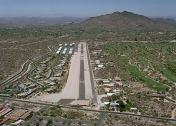
By: vaillajo


