Login
Register


1W3
Mexico Farms Airport
Official FAA Data Effective 2025-12-25 0901Z
Chart Supplement

VFR Chart of 1W3
Sectional Charts at SkyVector.com
IFR Chart of 1W3
Enroute Charts at SkyVector.com
Location Information for 1W3
Coordinates: N39°36.36' / W78°45.63'Located 03 miles S of Cumberland, Maryland on 50 acres of land. View all Airports in Maryland.
Estimated Elevation is 607 feet MSL.
Operations Data
|
|
Airport Communications
| UNICOM: | 122.800 |
|---|---|
| CTAF: | 122.800 |
| AWOS-3 at CBE (0.7 N): | 128.625 304-738-0451 |
| AWOS-3 at 2G4 (26.9 W): | 120.125 301-746-8443 |
| AWOS-3P at 2G9 (28.6 NW): | 133.8 814-443-2114 |
Nearby Navigation Aids
|
| ||||||||||||||||||||||||||||||||||||||||||||||||||||||||||||


Runway 09/27
| Dimensions: | 2120 x 75 feet / 646 x 23 meters | |
|---|---|---|
| Surface: | Turf in Good Condition MAY BE SOFT. | |
| Runway 09 | Runway 27 | |
| Coordinates: | N39°36.34' / W78°45.85' | N39°36.38' / W78°45.40' |
| Elevation: | 607.0 | 607.0 |
| Traffic Pattern: | Right | Left |
| Runway Heading: | 85° True | 265° True |
| Displaced Threshold: | 326 Feet | |
| Obstacles: | 81 ft Trees 832 ft from runway, 176 ft left of center APCH SLOPE 20:1 TO DSPLCD THR AT CNTRLN. |
|
Services Available
| Fuel: | NONE |
|---|---|
| Transient Storage: | Tiedowns |
| Airframe Repair: | NONE |
| Engine Repair: | NONE |
| Bottled Oxygen: | NONE |
| Bulk Oxygen: | NONE |
Ownership Information
| Ownership: | Privately Owned | |
|---|---|---|
| Owner: | D. JOHNSON, D. WILSON, B. JOHNSON | |
| 14112 AIRPORT LN, SE | ||
| CUMBERLAND, MD 21502 | ||
| 301-724-5231 | ||
| Manager: | DONALD JOHNSON JR. | JILL JOHNSON. |
| 11107 MEXICO FARMS | ||
| CUMBERLAND, MD 21502 | ||
| 301-724-5231 | ||
Other Remarks
- ULTRALIGHT ACFT & WILDLIFE ON & INVOF ARPT.
- RISING TRRN 4500 FT W OF ARPT.
- FOR CD CTC JOHNSTOWN APCH AT 814-532-5960, WHEN APCH CLSD CTC CLEVELAND ARTCC AT 440-774-0213.
- DSPLCD THR MKD WITH CONES ON BOTH SIDES.
- 122.8 SHARED WITH CUMBERLAND MUNICIPAL 1/2 MI DUE N.
Nearby Airports with Instrument Procedures
| ID | Name | Heading / Distance | ||
|---|---|---|---|---|
 |
KCBE | Greater Cumberland Regional Airport | 355° | 0.6 |
|
2G4 | Garrett County Airport | 266° | 26.7 |
|
W35 | Potomac Airpark Airport | 079° | 28.0 |
|
2G9 | Somerset County Airport | 335° | 28.5 |
|
KHMZ | Bedford County Airport | 021° | 31.0 |
|
KMRB | Eastern Wv Regional/Shepherd Field Airport | 108° | 38.1 |
|
KOKV | Winchester Regional Airport | 133° | 39.9 |
|
W99 | Grant County Airport | 206° | 40.8 |
|
KJST | John Murtha Johnstown/Cambria County Airport | 355° | 42.7 |
|
KAOO | Altoona/Blair County Airport | 026° | 46.1 |
|
KVVS | Joseph A Hardy Connellsville Airport | 297° | 46.6 |
|
KFRR | Front Royal-Warren County Airport | 150° | 47.6 |
Airport Images
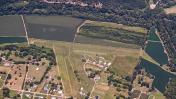
By: wkrozack
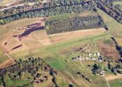
By: wkrozack


