Login
Register


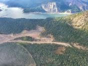
4S6
Tieton State Airport
Official FAA Data Effective 2024-06-13 0901Z
Chart Supplement

VFR Chart of 4S6
Sectional Charts at SkyVector.com
IFR Chart of 4S6
Enroute Charts at SkyVector.com
Location Information for 4S6
Coordinates: N46°38.25' / W121°7.44'Located 02 miles S of Rimrock, Washington on 15 acres of land. View all Airports in Washington.
Estimated Elevation is 2964 feet MSL.
Operations Data
|
|
Airport Communications
| CTAF: | 122.900 |
|---|---|
| ASOS at YKM (24.3 E): | 509-248-1502 |
| ATIS at YKM (24.3 E): | 125.25 |
| ASOS at FCT (27.6 E): | 118.15 |
Nearby Navigation Aids
|
| ||||||||||||||||||||||||||||||||||||||||||


Runway 02/20
| Dimensions: | 2509 x 100 feet / 765 x 30 meters | |
|---|---|---|
| Surface: | Turf in Fair Condition SFC GRASS & SMALL GRAVEL. | |
| Runway 02 | Runway 20 | |
| Coordinates: | N46°38.10' / W121°7.64' | N46°38.40' / W121°7.24' |
| Elevation: | 2964.0 | |
| Traffic Pattern: | Left | Left |
| Obstacles: | 33 ft Trees 30 ft from runway, 74 ft right of center TREES ARE ON TOP OF MOUNTAIN/HILL. |
199 ft Trees 894 ft from runway, 74 ft right of center |
Services Available
| Fuel: | NONE |
|---|---|
| Transient Storage: | Tiedowns TIEDOWNS PILOT PROVIDED. |
| Airframe Repair: | NONE |
| Engine Repair: | NONE |
| Bottled Oxygen: | NONE |
| Bulk Oxygen: | NONE |
Ownership Information
| Ownership: | Publicly owned | |
|---|---|---|
| Owner: | WSDOT AVIATION DIVISION | |
| 7702 TERMINAL STREET SW | ||
| TUMWATER, WA 98501-7264 | ||
| (800) 552-0666 | 8OO NR FOR WA STATE CALLS ONLY. | |
| Manager: | G. PAUL WOLF | |
| 7702 TERMINAL STREET SW | ||
| TUMWATER, WA 98501-7264 | ||
| (360) 618-2477 | ||
Operational Statistics
| Single Engine Aircraft Based on Field: | none | Statistics collected for 12 month period ending 2020-12-31 | |
|---|---|---|---|
| Multi-Engine Aircraft Based on Field: | none | Annual Commercial Operations: | none |
| Jet Aircraft Based on Field: | none | Annual Commuter Operations: | none |
| Helicopters Based on Field: | none | Annual Air Taxi Operations: | none |
| Military Aircraft Based on Field: | none | Annual Military Operations: | none |
| Gliders Based on Field: | none | Annual GA Local Operations: | none |
| Ultralights Based on Field: | none | Annual GA Itinerant Operations: | 300 |
Other Remarks
- FOR CD CTC SEATTLE ARTCC AT 253-351-3694.
- ARPT CLSD 1 OCT - 1 JUN EXC FOR APPROVED PUBLIC SAFETY/LAW ENFORCEMENT HELI OPS. BE ALERT, ARPT WINTER RECREATION ACTIVITIES DURING ARPT CLSD PERIODS. MIL, LOW APCH ONLY DURING CLSD PERIODS.
- RY 02 OBSTRUCTED BY MTNS AT 1000 FT.
- GROUND RISES TO NE.
- CTC WA STATE AVIATION DIVISION 360-709-8015 OR 1-800-552-0666 WA AREA FOR FACILITY INFO PRIOR TO USE.
- VEHICLES, PEDESTRIANS, AND ANIMALS ON AND INVOF ARPT.
- RY MARKED WITH REFLECTORS DURING DATES ARPT IS OPEN.
- FOR ACFT ACCIDENTS/INCIDENTS CTC WA STATE EMERGENCY OPERATIONS CENTER 800-258-5990.
- MOUNTAINOUS TRRN SURROUNDS ARPT.
Nearby Airports with Instrument Procedures
| ID | Name | Heading / Distance | ||
|---|---|---|---|---|
 |
KYKM | Yakima Air Trml/Mcallister Field Airport | 099° | 24.3 |
|
KELN | Bowers Field Airport | 045° | 34.2 |
|
KPLU | Pierce County - Thun Field Airport | 300° | 55.5 |
|
KEAT | Pangborn Memorial Airport | 039° | 59.2 |
|
KDLS | Columbia Gorge Regional/The Dalles Municipal Airport | 181° | 61.1 |
|
S50 | Auburn Municipal Airport | 312° | 61.4 |
|
KTCM | Mcchord Field (Joint Base Lewis-Mcchord) Airport | 298° | 63.2 |
|
KGRF | Gray AAF (Joint Base Lewis-Mcchord) Airport | 294° | 65.6 |
|
KRNT | Renton Municipal Airport | 319° | 68.1 |
|
KSEA | Seattle-Tacoma International Airport | 315° | 68.9 |
|
KTDO | Ed Carlson Memorial Field/South Lewis County Airport | 262° | 70.3 |
|
KTIW | Tacoma Narrows Airport | 302° | 70.7 |