Login
Register


EAT
Pangborn Memorial Airport
Official FAA Data Effective 2024-04-18 0901Z
Chart Supplement

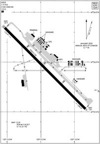
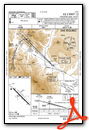
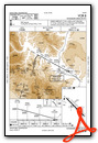
KEAT Airport Diagram
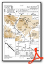
VFR Chart of KEAT
Sectional Charts at SkyVector.com
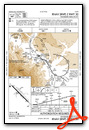
IFR Chart of KEAT
Enroute Charts at SkyVector.com
Location Information for KEAT
Coordinates: N47°23.93' / W120°12.41'Located 04 miles E of Wenatchee, Washington on 665 acres of land. View all Airports in Washington.
Surveyed Elevation is 1248 feet MSL.
Operations Data
|
|
Airport Communications
| ASOS: | 119.925 Tel. 509-886-4226 |
|---|---|
| UNICOM: | 123.000 |
| CTAF: | 123.000 |
| ASOS at ELN (25.6 SW): | 118.375 509-925-2040 |
| ASOS at EPH (28.6 E): | 135.775 509-754-3761 |
| ASOS at MWH (37.9 E): | 119.05 509-762-5082 |
- APCH/DEP CTL SVC PRVDD BY SEATTLE ARTCC (ZSE) ON FREQS 126.1 (WENATCHEE RCAG).
Nearby Navigation Aids
|
| ||||||||||||||||||||||||||||||||||||||||||||||||


Runway 12/30
| Dimensions: | 7000 x 150 feet / 2134 x 46 meters | |
|---|---|---|
| Surface: | Asphalt in Good Condition | |
| Weight Limits: | 46 /F/A/X/T, S-116, D-192 | |
| Edge Lighting: | High Intensity | |
| Runway 12 | Runway 30 | |
| Coordinates: | N47°24.34' / W120°13.04' | N47°23.53' / W120°11.84' |
| Elevation: | 1216.8 | 1231.0 |
| Traffic Pattern: | Right | Left |
| Runway Heading: | 135° True | 315° True |
| Declared Distances: | TORA:7000 TODA:7000 ASDA:7000 LDA:7000 | TORA:7000 TODA:7000 ASDA:7000 LDA:7000 |
| Markings: | Precision Instrument in good condition. | Non-Precision Instrument in good condition. |
| Glide Slope Indicator | P4L (3.60° Glide Path Angle) | P2L (4.30° Glide Path Angle) |
| Approach Lights: | MALSR 1,400 Foot Medium-intensity Approach Lighting System with runway alignment indicator lights. | |
| REIL: | Yes | |
| Obstacles: | 18 ft Road 500 ft from runway, 280 ft left of center | |
Services Available
| Fuel: | 100LL (blue), Jet-A |
|---|---|
| Transient Storage: | Tiedowns |
| Airframe Repair: | MAJOR |
| Engine Repair: | MAJOR |
| Bottled Oxygen: | NONE |
| Bulk Oxygen: | HIGH/LOW |
| Other Services: | AIR FREIGHT SERVICES,AIR AMBULANCE SERVICES,GLIDER SERVICE,PILOT INSTRUCTION,AIRCRAFT RENTAL,GLIDER TOWING SERVICES |
Ownership Information
| Ownership: | Publicly owned | |
|---|---|---|
| Owner: | PORTS CHELAN&DOUGLAS CNTY | |
| ONE CAMPBELL PARKWAY | ||
| EAST WENATCHEE, WA 98802 | ||
| 509-884-4700 | ||
| Manager: | TRENT MOYERS | |
| ONE CAMPBELL PARKWAY | ||
| EAST WENATCHEE, WA 98802 | ||
| 509-884-4700 | ||
Operational Statistics
| Single Engine Aircraft Based on Field: | 82 | Statistics collected for 12 month period ending 2017-12-31 | |
|---|---|---|---|
| Multi-Engine Aircraft Based on Field: | 7 | Annual Commercial Operations: | 2072 |
| Jet Aircraft Based on Field: | 2 | Annual Commuter Operations: | none |
| Helicopters Based on Field: | 5 | Annual Air Taxi Operations: | 2424 |
| Military Aircraft Based on Field: | none | Annual Military Operations: | 500 |
| Gliders Based on Field: | 10 | Annual GA Local Operations: | 28380 |
| Ultralights Based on Field: | 2 | Annual GA Itinerant Operations: | 11000 |
Other Remarks
- GLIDER ACTIVITY FROM MAR-NOV.
- COLD TEMPERATURE AIRPORT. ALTITUDE CORRECTION REQUIRED AT OR BELOW -7C.
- UAS ACTVTY 1.56 NM E OF THE EAT VOR, 400 FT & BLW DURG DALGT HRS.
- FOR CD IF UNA TO CTC ON FSS FREQ, CTC SEATTLE ARTCC AT 253-351-3694.
- ACTVT MALSR RWY 12; REIL 30; HIRL RWY 12/30 - CTAF. PAPI RWY 12 & 30 OPR CONSLY.
Weather Minimums
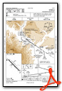
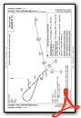
Instrument Approach Procedure (IAP) Charts
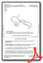
Departure Procedure (DP) Charts
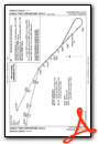
Departure Procedure Obstacles (DPO) Charts
Nearby Airports with Instrument Procedures
| ID | Name | Heading / Distance | ||
|---|---|---|---|---|
 |
KELN | Bowers Field Airport | 211° | 25.5 |
|
KEPH | Ephrata Municipal Airport | 100° | 28.7 |
|
KMWH | Grant County International Airport | 107° | 38.0 |
|
KYKM | Yakima Air Trml/Mcallister Field Airport | 195° | 51.7 |
|
2S8 | Wilbur Airport | 069° | 63.1 |
|
KOMK | Omak Airport | 023° | 69.8 |
|
KRLD | Richland Airport | 150° | 75.4 |
|
KPSC | Tri-Cities Airport | 146° | 81.5 |
|
KRNT | Renton Municipal Airport | 274° | 82.0 |
|
S50 | Auburn Municipal Airport | 267° | 82.5 |
|
S43 | Harvey Field Airport | 292° | 82.7 |
|
KBFI | Boeing Field/King County International Airport | 276° | 85.7 |
Airport Images

By: Yoesmaan

By: Yoesmaan


