Login
Register
66V
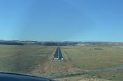
Bluff Airport
Official FAA Data Effective 2024-12-26 0901Z
VFR Chart of 66V
Sectional Charts at SkyVector.com
IFR Chart of 66V
Enroute Charts at SkyVector.com
Location Information for 66V
Coordinates: N37°15.30' / W109°37.98'Located 04 miles SW of Bluff, Utah on 72 acres of land. View all Airports in Utah.
Estimated Elevation is 4476 feet MSL.
Operations Data
|
|
Airport Communications
| CTAF: | 122.900 |
|---|---|
| AWOS-3PT at BDG (21.0 N): | 127.75 435-678-2636 |
| AWOS-3PT at U64 (43.1 N): | 121.025 435-298-8856 |
| AWOS-3PT at 0V7 (43.3 SW): | 119.325 928-697-3638 |
Nearby Navigation Aids
|
| ||||||||||||||||||||||||||||||||||||
Runway 03/21
| Dimensions: | 3000 x 45 feet / 914 x 14 meters | |
|---|---|---|
| Surface: | Asphalt in Fair Condition | |
| Runway 03 | Runway 21 | |
| Coordinates: | N37°15.13' / W109°38.20' | N37°15.47' / W109°37.76' |
| Elevation: | 4463.0 | 4474.0 |
| Traffic Pattern: | Left | Left |
| Runway Heading: | 45° True | 225° True |
| Markings: | Basic in good condition. | Basic in good condition. |
| Obstacles: | 10 ft Road 201 ft from runway, 45 ft left of center CTLG OBSTN EXCEEDS A 45 DEG SLOPE. 20 FT DIRT RD PARALLEL TO RWY, 45 FT LEFT OF RWY CNTRLN. |
|
Services Available
| Fuel: | NONE |
|---|---|
| Transient Storage: | Tiedowns |
| Airframe Repair: | NONE |
| Engine Repair: | NONE |
| Bottled Oxygen: | NONE |
| Bulk Oxygen: | NONE |
Ownership Information
| Ownership: | Publicly owned | |
|---|---|---|
| Owner: | TOWN OF BLUFF | LEASED FROM THE BLM. |
| PO BOX 324, P.O. BOX 338 | ||
| BLUFF, UT 84512 | ||
| 435-672-9990 | ||
| Manager: | JIM HOOK | |
| PO BOX 324 | ||
| BLUFF, UT 84512 | ||
| 435-672-2281 | ||
Other Remarks
- GRVL PIT 1/4 MILE OFF AER 21.
- FOR CD CTC DENVER ARTCC AT 303-651-4257.
Nearby Airports with Instrument Procedures
| ID | Name | Heading / Distance | ||
|---|---|---|---|---|
 |
KBDG | Blanding Municipal Airport | 019° | 20.9 |
 |
U64 | Monticello Airport | 018° | 42.9 |
 |
KCEZ | Cortez Municipal Airport | 086° | 48.2 |
 |
KFMN | Four Corners Regional Airport | 114° | 74.1 |
 |
KAIB | Hopkins Field Airport | 040° | 77.9 |
 |
KPGA | Page Municipal Airport | 257° | 89.3 |
 |
KDRO | Durango-La Plata County Airport | 093° | 90.3 |
 |
KCNY | Canyonlands Regional Airport | 356° | 90.2 |
 |
KTEX | Telluride Regional Airport | 062° | 92.3 |
 |
1L7 | Escalante Municipal Airport | 288° | 97.0 |
 |
KRQE | Window Rock Airport | 163° | 99.9 |
 |
U34 | Green River Municipal Airport | 344° | 106.1 |


