Login
Register
7PN4
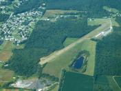
Blue Knob Valley Airport
Official FAA Data Effective 2026-01-22 0901Z
VFR Chart of 7PN4
Sectional Charts at SkyVector.com
IFR Chart of 7PN4
Enroute Charts at SkyVector.com
Location Information for 7PN4
Coordinates: N40°23.79' / W78°27.22'Located 01 miles W of Newry, Pennsylvania on 20 acres of land. View all Airports in Pennsylvania.
Surveyed Elevation is 1270 feet MSL.
Operations Data
|
|
Airport Communications
| UNICOM: | 122.800 |
|---|---|
| ASOS at AOO (8.6 SE): | 127.125 814-793-9655 |
| ASOS at JST (18.1 W): | 814-535-3511 |
| ATIS at JST (18.1 W): | 118.325 |
Nearby Navigation Aids
|
| ||||||||||||||||||||||||||||||||||||||||||||||||||||||||||||
Runway 11/29
| Dimensions: | 3415 x 89 feet / 1041 x 27 meters | |
|---|---|---|
| Surface: | Gravel in Good Condition LOOSE STONES ON RWY. LOOSE STONES & TALL GRASS ON TWY & RAMP. | |
| Runway 11 | Runway 29 | |
| Coordinates: | N40°23.85' / W78°27.58' | N40°23.73' / W78°26.86' |
| Elevation: | 1270.0 | 1263.0 |
| Traffic Pattern: | Left | Right |
| Displaced Threshold: | 300 Feet RY 11 DSPLCD THLD MKD WITH YELLOW L'S EACH SIDE. |
|
| Obstacles: | 9 ft Road 0 ft from runway, 81 ft left of center APCH RATIO 20:1 TO DSPLCD THLD. |
18 ft Trees 73 ft from runway, 91 ft left of center |
Services Available
| Fuel: | NONE |
|---|---|
| Transient Storage: | Tiedowns |
| Airframe Repair: | NONE |
| Engine Repair: | NONE |
| Bottled Oxygen: | NOT AVAILABLE |
| Bulk Oxygen: | NOT AVAILABLE |
Ownership Information
| Ownership: | Privately Owned | |
|---|---|---|
| Owner: | FELD'S FIELD, LLC | |
| 1460 FOOT OF TEN ROAD | ||
| DUNCANSVILLE, PA 16635 | ||
| 814-502-8867 | ||
| Manager: | BERNARD B. STAPELFELD | |
| 200 AIRPORT ROAD | ||
| DUNCANSVILLE, PA 16635 | ||
| 814-329-5750 | ||
Other Remarks
- ARPT SURROUNDED BY MOUNTAINS.
- RWY MAY NOT BE MAINTAINED DURING WINTER; CALL PRIOR TO USE.
- FOR CD CTC JOHNSTOWN APCH AT 814-532-5960, WHEN APCH CLSD CTC CLEVELAND ARTCC AT 440-774-0234.
- SFC IS ROLLED SLATE.
- RWY MARKED WITH YELLOW BARRELS.
Nearby Airports with Instrument Procedures
| ID | Name | Heading / Distance | ||
|---|---|---|---|---|
 |
KAOO | Altoona/Blair County Airport | 134° | 8.6 |
 |
9G8 | Ebensburg Airport | 284° | 15.2 |
 |
KJST | John Murtha Johnstown/Cambria County Airport | 254° | 18.1 |
 |
KHMZ | Bedford County Airport | 188° | 18.8 |
 |
KIDI | Indiana County/Jimmy Stewart Field Airport | 295° | 32.8 |
 |
2G9 | Somerset County Airport | 230° | 33.6 |
 |
KPSB | Mid-State Airport | 029° | 33.7 |
 |
KUNV | State College Regional Airport | 045° | 38.8 |
 |
KFIG | Clearfield-Lawrence Airport | 002° | 39.2 |
 |
N35 | Punxsutawney Municipal Airport | 327° | 40.5 |
 |
N96 | Bellefonte Airport | 044° | 41.3 |
 |
KRVL | Mifflin County Airport | 065° | 41.4 |


