Login
Register
85U
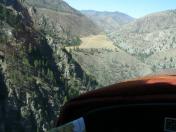
Soldier Bar USFS Airport
Official FAA Data Effective 2026-01-22 0901Z
VFR Chart of 85U
Sectional Charts at SkyVector.com
IFR Chart of 85U
Enroute Charts at SkyVector.com
Location Information for 85U
Coordinates: N45°5.99' / W114°48.06'Located 01 miles SW of Soldier Bar, Idaho on 6 acres of land. View all Airports in Idaho.
Estimated Elevation is 4190 feet MSL.
Operations Data
|
|
Airport Communications
| CTAF: | 122.900 |
|---|---|
| AWOS-3PT at SMN (39.0 E): | 135.075 208-756-4381 |
| ASOS at LLJ (42.7 SE): | 119.275 208-844-2785 |
| ASOS at MYL (56.5 W): | 119.925 208-634-5947 |
Nearby Navigation Aids
|
| ||||||||||||||||||||||||||||||
Runway 07/25
SHARP DOG LEG ON WEST 1/3 OF RY TO THE NORTH. LAND RY 25; TKOF RY 07. | ||
| Dimensions: | 1650 x 15 feet / 503 x 5 meters | |
|---|---|---|
| Surface: | Dirt in Fair Condition | |
| Runway 07 | Runway 25 | |
| Traffic Pattern: | Left | Left |
| Obstacles: | 90 ft Trees 200 ft from runway | 200 ft Hill 1100 ft from runway |
Services Available
| Fuel: | NONE |
|---|---|
| Transient Storage: | NONE |
| Airframe Repair: | NONE |
| Engine Repair: | NONE |
| Bottled Oxygen: | NOT AVAILABLE |
| Bulk Oxygen: | NOT AVAILABLE |
Ownership Information
| Ownership: | Publicly owned | |
|---|---|---|
| Owner: | U S FOREST SERVICE | |
| 324 25TH ST | ||
| OGDEN, UT 84401 | ||
| 801-625-5511 | ||
| Manager: | PAYETTE FOREST AIR OFFICER | |
| P.O. BOX 1026 | ||
| MC CALL, ID 83638 | ||
| 208-634-0746 | ||
Other Remarks
- STEEP CANYON WALLS IN ALL DRCTNS.
- ARPT ON BENCH 500 FT ABOVE BIG CREEK ON S SIDE.
- CABIN CREEK ARPT APPROX 7 MILES WEST UP BIG CREEK CANYON.
- WEST 1/3 OF RY HAS 4 DEG SLOPE DOWN TO THE NORTH.
- GO-AROUNDS NOT RECOMMENDED.
- NO TELEPHONE AVBL AT ARPT.
- FOR CD CTC SALT LAKE ARTCC AT 801-320-2568.
- RWY 7/25 HAS TWO BIG HUMPS ARND THE MID-FLD & TO THE W OF IT.
Nearby Airports with Instrument Procedures
| ID | Name | Heading / Distance | ||
|---|---|---|---|---|
 |
KSMN | Lemhi County Airport | 087° | 39.1 |
 |
KLLJ | Challis Airport | 144° | 42.6 |
 |
KMYL | Mc Call Municipal Airport | 257° | 56.8 |
 |
KHRF | Ravalli County Airport | 022° | 75.1 |
 |
KGIC | Idaho County Airport | 312° | 75.3 |
 |
32S | Stevensville Airport | 019° | 91.1 |
 |
KDLN | Dillon Airport | 083° | 95.9 |
 |
KSUN | Friedman Memorial Airport | 167° | 98.2 |
 |
3U3 | Bowman Field Airport | 051° | 103.1 |
 |
KJSY | Joseph State Airport | 279° | 105.2 |
 |
S87 | Weiser Municipal Airport | 240° | 107.0 |
 |
KRVF | Ruby Valley Field Airport | 075° | 109.0 |


