Login
Register


AKR
Akron Fulton International Airport
Official FAA Data Effective 2025-12-25 0901Z
Chart Supplement

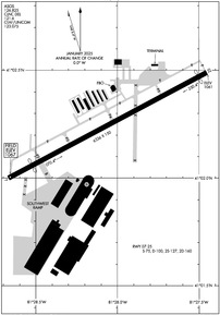
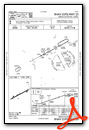
KAKR Airport Diagram
VFR Chart of KAKR
Sectional Charts at SkyVector.com
IFR Chart of KAKR
Enroute Charts at SkyVector.com
Location Information for KAKR
Coordinates: N41°2.25' / W81°28.06'Located 04 miles SE of Akron, Ohio on 1171 acres of land. View all Airports in Ohio.
Surveyed Elevation is 1067 feet MSL.
Operations Data
|
|
Airport Communications
| ASOS: | 126.825 Tel. 330-724-4237 |
|---|---|
| CLEVELAND APPROACH: | 125.5 371.875 |
| CLEVELAND DEPARTURE: | 125.5 371.875 |
| CLEARANCE DELIVERY: | 121.6 |
| CTAF: | 123.075 |
| UNICOM: | 123.075 |
| BRWNZ STAR: | 126.55 346.325 |
| ATIS at CAK (7.4 S): | 121.05 |
| ASOS at CAK (7.4 S): | 330-227-8682 |
| AWOS-2 at 1G3 (7.5 N): | 119.15 330-346-1497 |
- APCH/DEP SVC PRVDD BY CLEVELAND APCH (CLE) 0600-0100. APCH/DEP SVC PRVDD BY CLEVELAND ARTCC (ZOB) ON FREQS 120.6/379.275 (MOUNT HOPE RCAG) 0100-0600.
Nearby Navigation Aids
|
| ||||||||||||||||||||||||||||||||||||||||||||||||||||||||||||


Runway 07/25
| Dimensions: | 6336 x 150 feet / 1931 x 46 meters | |
|---|---|---|
| Surface: | Asphalt in Good Condition | |
| Weight Limits: | S-75, D-100, ST-160 | |
| Edge Lighting: | Medium Intensity | |
| Runway 07 | Runway 25 | |
| Coordinates: | N41°2.00' / W81°28.67' | N41°2.49' / W81°27.45' |
| Elevation: | 1067.3 | 1060.8 |
| Traffic Pattern: | Left | Left |
| Runway Heading: | 62° True | 242° True |
| Displaced Threshold: | 760 Feet | 262 Feet |
| Markings: | Non-Precision Instrument in good condition. | Non-Precision Instrument in good condition. |
| Glide Slope Indicator | P4L (3.60° Glide Path Angle) | P4L (4.00° Glide Path Angle) |
| REIL: | Yes | Yes |
| Obstacles: | 23 ft Railroad 201 ft from runway, 140 ft right of center 23 FT RAILROAD 0-200 FT FM, 155 FT L TO 140 FT RIGHT. |
125 ft Tree 1078 ft from runway, 427 ft left of center APCH RATIO 12:1 TO DSPLCD THR DUE TO +108 FT TREE 1310 FT FM THR 422 FT RIGHT. |
Services Available
| Fuel: | 100LL (blue), Jet-A |
|---|---|
| Transient Storage: | Hangars,Tiedowns PRIOR CDN RQRD. |
| Airframe Repair: | MAJOR |
| Engine Repair: | MAJOR |
| Bottled Oxygen: | NONE |
| Bulk Oxygen: | HIGH/LOW |
| Other Services: | AIR AMBULANCE SERVICES,CHARTER SERVICE,PILOT INSTRUCTION,AIRCRAFT RENTAL |
Ownership Information
| Ownership: | Publicly owned | |
|---|---|---|
| Owner: | CITY OF AKRON | |
| 166 S HIGH ST RM 701 | ||
| AKRON, OH 44308-1627 | ||
| 330-375-2699 | ||
| Manager: | ANTHONY PLUCINSKI | TONYP@SUMMITAIRPORTSERVICES.COM. |
| 1600 TRIPLETT BLVD | ||
| AKRON, OH 44306-3308 | ||
| 330-733-4760 | ||
Other Remarks
- FOR CD CTC CLEVELAND APCH AT 216-352-2323, WHEN APCH CLSD CTC CLEVELAND ARTCC AT 440-774-0223/0490.
- DEER ON & INVOF ARPT.
- ACTVT REIL RWY 07 & 25; PAPI RWY 07 & 25; MIRL RWY 07/25 - CTAF.
- ARPT BCN OPRS CONSLY.
Weather Minimums
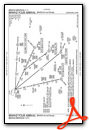
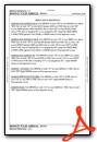
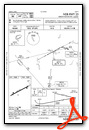
Standard Terminal Arrival (STAR) Charts
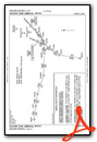
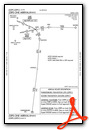
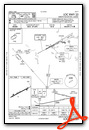
Instrument Approach Procedure (IAP) Charts
Nearby Airports with Instrument Procedures
| ID | Name | Heading / Distance | ||
|---|---|---|---|---|
 |
1G3 | Kent State University Airport | 019° | 7.2 |
|
KCAK | Akron-Canton Regional Airport | 171° | 7.4 |
|
3G3 | Wadsworth Municipal Airport | 261° | 13.3 |
|
KPOV | Portage County Airport | 043° | 14.3 |
|
1G5 | Medina Municipal Airport | 292° | 14.6 |
|
KBJJ | Wayne County Airport | 243° | 21.5 |
|
3G6 | Tri-City Airport | 110° | 22.7 |
|
38D | Salem Airpark Airport | 100° | 28.0 |
|
KCLE | Cleveland-Hopkins International Airport | 321° | 28.4 |
|
KBKL | Burke Lakefront Airport | 341° | 30.4 |
|
7G8 | Geauga County Airport | 036° | 30.8 |
|
KCGF | Cuyahoga County Airport | 358° | 31.6 |
Airport Images

By: btracy62


