Login
Register
BNO
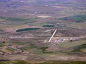
Burns Municipal Airport
Official FAA Data Effective 2026-01-22 0901Z
VFR Chart of KBNO
Sectional Charts at SkyVector.com
IFR Chart of KBNO
Enroute Charts at SkyVector.com
Location Information for KBNO
Coordinates: N43°35.51' / W118°57.33'Located 05 miles E of Burns, Oregon on 825 acres of land. View all Airports in Oregon.
Surveyed Elevation is 4148 feet MSL.
Operations Data
|
|
Airport Communications
| ASOS: | 135.575 Tel. 541-573-1382 |
|---|---|
| UNICOM: | 122.800 |
| CTAF: | 122.800 |
| AWOS-3 at GCD (48.7 N): | 118.375 541-575-1122 |
| ASOS at ONO (88.0 E): | 135.275 541-889-7388 |
| AWOS-3PT at S39 (93.9 NW): | 118.325 541-447-4060 |
- COMMUNICATIONS PRVDD BY MC MINNVILLE RADIO ON FREQ 122.5 (BURNS RCO).
- APCH/DEP CTL SVC PRVDD BY SALT LAKE ARTCC (ZLC) ON 128.05/306.95 (BAKER RCAG).
Nearby Navigation Aids
|
| ||||||||||||||||||
Runway 12/30
| Dimensions: | 5101 x 75 feet / 1555 x 23 meters | |
|---|---|---|
| Surface: | Concrete in Good Condition | |
| Weight Limits: | S-30, D-50, ST-90 | |
| Edge Lighting: | Medium Intensity | |
| Runway 12 | Runway 30 | |
| Coordinates: | N43°35.82' / W118°57.85' | N43°35.23' / W118°57.03' |
| Elevation: | 4147.7 | 4144.3 |
| Traffic Pattern: | Left | Left |
| Runway Heading: | 135° True | 315° True |
| Markings: | Basic in good condition. | Non-Precision Instrument in good condition. |
| Glide Slope Indicator | V2L (3.00° Glide Path Angle) | V2L (3.00° Glide Path Angle) |
| REIL: | Yes | Yes |
| Obstacles: | 14 ft Road 900 ft from runway, 205 ft left of center | |
Runway 03/21
| Dimensions: | 4600 x 60 feet / 1402 x 18 meters | |
|---|---|---|
| Surface: | Concrete in Good Condition | |
| Weight Limits: | S-30 | |
| Edge Lighting: | Medium Intensity | |
| Runway 03 | Runway 21 | |
| Coordinates: | N43°35.25' / W118°57.58' | N43°35.76' / W118°56.81' |
| Elevation: | 4146.2 | 4143.7 |
| Traffic Pattern: | Left | Left |
| Runway Heading: | 48° True | 228° True |
| Displaced Threshold: | 600 Feet | |
| Markings: | Basic in good condition. | Basic in good condition. |
| Glide Slope Indicator | P2L (3.00° Glide Path Angle) | P2L (3.00° Glide Path Angle) |
| REIL: | Yes | Yes |
| Obstacles: | 32 ft Power Line 900 ft from runway RWY 03 APRCH RATIO 50:1 TO DSPLCD THR. |
|
Services Available
| Fuel: | 100LL (blue), Jet-A |
|---|---|
| Transient Storage: | Hangars,Tiedowns |
| Airframe Repair: | NONE |
| Engine Repair: | NONE |
| Bottled Oxygen: | NONE |
| Bulk Oxygen: | NONE |
Ownership Information
| Ownership: | Publicly owned | |
|---|---|---|
| Owner: | CITY OF BURNS | |
| 242 S. BROADWAY | ||
| BURNS, OR 97720 | ||
| 541-573-5255 | ||
| Manager: | SCOTT WILLIAMSON | |
| 70346 TERMINAL WAY | ||
| BURNS, OR 97720 | ||
| 541-480-3854 | ||
Other Remarks
- FLOCKS OF LARGE BIRDS INVOF ARPT FEB - MAY & SEP - OCT.
- FOR CD IF UNA TO CTC ON FSS FREQ, CTC SALT LAKE ARTCC AT 801-320-2568.
- ACTVT MIRL RYS 03/21 & 12/30, PAPI RYS 03 & 21, VASI RYS 12 & 30, & REILS RYS 03, 21, 12, & 30 - CTAF.
Weather Minimums
Instrument Approach Procedure (IAP) Charts
Nearby Airports with Instrument Procedures
| ID | Name | Heading / Distance | ||
|---|---|---|---|---|
 |
KGCD | Grant County Regional/Ogilvie Field Airport | 359° | 48.7 |
 |
62S | Christmas Valley Airport | 254° | 77.7 |
 |
KONO | Ontario Municipal Airport | 072° | 88.2 |
 |
KBKE | Baker City Municipal Airport | 033° | 89.6 |
 |
S87 | Weiser Municipal Airport | 066° | 94.0 |
 |
S39 | Prineville Airport | 296° | 94.3 |
 |
KEUL | Caldwell Exec Airport | 087° | 101.1 |
 |
KBDN | Bend Municipal Airport | 287° | 102.0 |
 |
KRDM | Roberts Field Airport | 293° | 103.1 |
 |
KMAN | Nampa Municipal Airport | 089° | 106.1 |
 |
KLKV | Lake County Airport | 217° | 106.9 |
 |
S21 | Sunriver Airport | 279° | 110.0 |


