Login
Register


BVS
Skagit Regional Airport
Official FAA Data Effective 2025-11-27 0901Z
Chart Supplement

VFR Chart of KBVS
Sectional Charts at SkyVector.com
IFR Chart of KBVS
Enroute Charts at SkyVector.com
Location Information for KBVS
Coordinates: N48°28.23' / W122°25.30'Located 03 miles W of Burlington/Mount Vernon, Washington on 1847 acres of land. View all Airports in Washington.
Surveyed Elevation is 145 feet MSL.
ULTRALIGHT TPA 500 FT AGL.
Operations Data
|
|
Airport Communications
| AWOS-3: | 121.125 Tel. 360-757-7767 |
|---|---|
| WHIDBEY APPROACH: | 120.7 270.8 |
| WHIDBEY DEPARTURE: | 120.7 270.8 |
| CTAF: | 123.075 |
| UNICOM: | 123.075 |
| ASOS at NUW (11.7 SW): | 360-257-8813 |
| ATIS at NUW (11.7 SW): | 134.15 |
| AWOS-3 at OKH (16.6 SW): | 132.775 360-675-8431 |
Nearby Navigation Aids
|
| ||||||||||||||||||||||||||||||||||||||||||||||||||||||||||||


Runway 11/29
| Dimensions: | 5480 x 100 feet / 1670 x 30 meters | |
|---|---|---|
| Surface: | Asphalt in Excellent Condition | |
| Weight Limits: | S-60, D-75, ST-125 | |
| Edge Lighting: | Medium Intensity | |
| Runway 11 | Runway 29 | |
| Coordinates: | N48°28.67' / W122°25.86' | N48°28.14' / W122°24.77' |
| Elevation: | 145.1 | 103.2 |
| Traffic Pattern: | Left | Left |
| Runway Heading: | 126° True | 306° True |
| Markings: | Non-Precision Instrument in fair condition. | Non-Precision Instrument in fair condition. |
| Glide Slope Indicator | P4L (3.00° Glide Path Angle) | P4L (3.00° Glide Path Angle) |
| REIL: | Yes | Yes |
Runway 04/22
| Dimensions: | 3000 x 60 feet / 914 x 18 meters | |
|---|---|---|
| Surface: | Asphalt in Poor Condition WDSPR, OPN, UNSEALED CRACKS AND JOINTS. | |
| Weight Limits: | S-12 | |
| Edge Lighting: | Low Intensity | |
| Runway 04 | Runway 22 | |
| Coordinates: | N48°27.78' / W122°25.59' | N48°28.05' / W122°24.98' |
| Elevation: | 84.0 | 93.9 |
| Traffic Pattern: | Left | |
| Runway Heading: | 56° True | 236° True |
| Markings: | Basic in poor condition. | Basic in poor condition. |
| Glide Slope Indicator | P2L (4.00° Glide Path Angle) | P2L (3.00° Glide Path Angle) |
Services Available
| Fuel: | 100LL (blue), Jet-A |
|---|---|
| Transient Storage: | Tiedowns |
| Airframe Repair: | MAJOR |
| Engine Repair: | MAJOR |
| Bottled Oxygen: | HIGH/LOW |
| Bulk Oxygen: | NONE |
| Other Services: | AIR FREIGHT SERVICES,AVIONICS,CHARTER SERVICE,PILOT INSTRUCTION,AIRCRAFT RENTAL,AIRCRAFT SALES |
Ownership Information
| Ownership: | Publicly owned | |
|---|---|---|
| Owner: | PORT OF SKAGIT COUNTY | |
| 15400 AIRPORT DR, PO BOX 348 | ||
| BURLINGTON, WA 98233 | ||
| 360-757-0011 | ||
| Manager: | KEITH D. LOVE | |
| 15400 AIRPORT DR, 15400 AIRPORT DR | ||
| BURLINGTON, WA 98233 | ||
| 360-757-0011 | ||
Other Remarks
- FOR CD CTC WHIDBEY APCH AT 360-257-3310.
- RWY 04/22 CLSD TO ACFT MORE THAN 12500 LB AND WINGSPAN MORE THAN 49 FT.
- MIGRATORY WATERFOWL & BIRDS ON AND INVOF ARPT.
- HELICOPTER TRAINING OPS ON AIRPORT W/ AUTOROTATIONS ON RUNWAY
- USE OF TWY B BY ACFT WITH WINGSPAN 49 FT OR GREATER PROHIBITED WHEN RY 04/22 IN USE.
- POSSIBLE TURBULENCE INVOF EXHAUST STACKS 3,500 FT SW OF RW 04, AVOID LOW ALT OVERFLT.
- U.S. CUST SVC AVBL FOR INTL ARR. CHK PORT OF SKAGIT WEBSITE FOR REQ FOR SVC INSRT, WWW.PORTOFSKAGIT.COM. AVBL SEVEN DAYS A WEEK, PER APVL. USAGE FEES APPLY.
- MARKINGS FADED.
- MARKINGS FADED.
- ACTVT MIRL RY 11/29, LIRL RY 04/22, PAPI RY 11 & 29, AND REIL RY 11 & 29 - CTAF. PAPI RYS 04 & 22 OPR CONTINUOUSLY.
- ULTRALIGHT TPA 500 FT AGL.
Weather Minimums

Instrument Approach Procedure (IAP) Charts

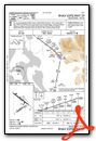
Nearby Airports with Instrument Procedures
| ID | Name | Heading / Distance | ||
|---|---|---|---|---|
 |
KNUW | Whidbey Island NAS (Ault Field) Airport | 232° | 11.8 |
|
KOKH | Delaurentis Airport | 217° | 16.6 |
|
KBLI | Bellingham International Airport | 346° | 19.9 |
|
KAWO | Arlington Municipal Airport | 150° | 21.4 |
|
KORS | Orcas Island Airport | 306° | 24.1 |
|
KFHR | Friday Harbor Airport | 277° | 24.2 |
|
0S9 | Jefferson County International Airport | 212° | 29.5 |
|
CYXX | Abbotsford Airport | 004° | 33.4 |
|
KPAE | Seattle Paine Field International Airport | 170° | 34.3 |
|
S43 | Harvey Field Airport | 159° | 36.3 |
|
CYYJ | Victoria International Airport | 285° | 41.4 |
|
KNOW | Port Angeles CGAS Airport | 243° | 44.4 |
Airport Images

By: Tom


Comments
TPA for KBVS correct?
The TPA for BVS is listed at 500AGL. Should be 1000 AGL?
TPA
The 500' AGL TPA is for ultralights only.