Login
Register
C24
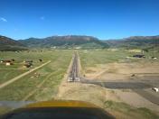
Mineral County Memorial Airport
Official FAA Data Effective 2026-01-22 0901Z
VFR Chart of C24
Sectional Charts at SkyVector.com
IFR Chart of C24
Enroute Charts at SkyVector.com
Location Information for C24
Coordinates: N37°49.33' / W106°55.79'Located 02 miles SSW of Creede, Colorado on 100 acres of land. View all Airports in Colorado.
Estimated Elevation is 8680 feet MSL.
Operations Data
|
|
Airport Communications
| AWOS-3: | 120.00 Tel. 719-658-1011 |
|---|---|
| CTAF: | 122.900 |
| AWOS-3 at CPW (22.3 S): | 121.125 970-264-2180 |
| AWOS-3PT at RCV (28.1 E): | 118.275 719-657-9017 |
| AWOS-3PT at PSO (32.5 S): | 127.175 970-731-0365 |
Nearby Navigation Aids
|
| ||||||||||||||||||||||||||||||||||||
Runway 07/25
| Dimensions: | 6880 x 60 feet / 2097 x 18 meters | |
|---|---|---|
| Surface: | Asphalt in Fair Condition | |
| Weight Limits: | S-12 | |
| Runway 07 | Runway 25 | |
| Coordinates: | N37°49.26' / W106°56.50' | N37°49.40' / W106°55.08' |
| Elevation: | 8630.0 | |
| Traffic Pattern: | Left | Left |
| Displaced Threshold: | 188 Feet | |
| Markings: | Basic in good condition. | Basic in fair condition. |
Services Available
| Fuel: | 100LL (blue), Jet-A |
|---|---|
| Transient Storage: | Tiedowns |
| Airframe Repair: | NONE |
| Engine Repair: | NONE |
| Bottled Oxygen: | NONE |
| Bulk Oxygen: | NONE |
Ownership Information
| Ownership: | Publicly owned | |
|---|---|---|
| Owner: | MINERAL COUNTY | |
| BOX 70 | ||
| CREEDE, CO 81130 | ||
| 719-658-2331 | ||
| Manager: | ROGER DUNCAN | |
| BOX 70 | ||
| CREEDE, CO 81130 | ||
| 719-658-2360 | 719-658-2600 CO SHERIFF 24 HRS. | |
Other Remarks
- MT ALL QUADS.
- DEP NE AVOID OVERFLIGHT OF TRAILERS & HOMES; CLIMB TO +200 FT AGL ON RCL BFR TURN.
- GLIDER ACT & WILDLIFE ON & INVOF ARPT.
- FOR CD CTC DENVER ARTCC AT 303-651-4257.
Nearby Airports with Instrument Procedures
| ID | Name | Heading / Distance | ||
|---|---|---|---|---|
 |
KRCV | Astronaut Kent Rominger Airport | 103° | 28.2 |
 |
KPSO | Stevens Field Airport | 190° | 32.7 |
 |
KGUC | Gunnison-Crested Butte Regional Airport | 359° | 42.7 |
 |
KMVI | Monte Vista Municipal Airport | 112° | 45.6 |
 |
KTEX | Telluride Regional Airport | 279° | 47.2 |
 |
KALS | San Luis Valley Regional/Bergman Field Airport | 114° | 55.7 |
 |
KDRO | Durango-La Plata County Airport | 224° | 56.2 |
 |
KANK | Salida/Harriett Alexander Field Airport | 043° | 59.8 |
 |
KMTJ | Montrose Regional Airport | 312° | 61.5 |
 |
KAEJ | Central Colorado Regional Airport | 032° | 70.7 |
 |
KAJZ | Blake Field Airport | 317° | 78.7 |
 |
KAIB | Hopkins Field Airport | 288° | 81.3 |


Comments
Location description for C24 Mineral County Airport, Colorado
SkyVector's description says: Located 02 miles E of Creede, Colorado.
Looking at Google Maps overhead (satellite) view, and the SkyVector sectional chart, C24 is more like 1 mi South of Creede.