Login
Register
CA89
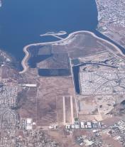
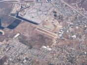
Skylark Airport
Official FAA Data Effective 2025-12-25 0901Z
VFR Chart of CA89
Sectional Charts at SkyVector.com
IFR Chart of CA89
Enroute Charts at SkyVector.com
Location Information for CA89
Coordinates: N33°37.98' / W117°18.09'Located 04 miles S of Lake Elsinore, California on 150 acres of land. View all Airports in California.
Estimated Elevation is 1262 feet MSL.
Operations Data
|
|
Airport Communications
| AWOS-3 at F70 (9.2 E): | 119.025 951-696-1018 |
|---|---|
| AWOS-3PT at HMT (14.9 NE): | 118.375 951-925-6886 |
| ATIS at RIV (15.1 N): | 134.75 |
Nearby Navigation Aids
|
| ||||||||||||||||||||||||||||||||||||||||||
Runway 11R/29L
| Dimensions: | 2701 x 100 feet / 823 x 30 meters | |
|---|---|---|
| Surface: | Gravel-Dirt in Excellent Condition | |
| Runway 11R | Runway 29L | |
| Coordinates: | N33°38.08' / W117°18.33' | N33°37.80' / W117°17.91' |
| Elevation: | 1249.0 | 1259.0 |
| Traffic Pattern: | Right | |
| Markings: | Basic | Basic |
Runway 11L/29R
| Dimensions: | 2575 x 100 feet / 785 x 30 meters | |
|---|---|---|
| Surface: | Gravel-Dirt in Excellent Condition | |
| Runway 11L | Runway 29R | |
| Coordinates: | N33°38.15' / W117°18.27' | N33°37.88' / W117°17.87' |
| Elevation: | 1252.0 | 1262.0 |
| Traffic Pattern: | Right | |
| Markings: | Basic | Basic |
Services Available
| Fuel: | NONE |
|---|---|
| Transient Storage: | NONE |
| Airframe Repair: | NOT AVAILABLE |
| Engine Repair: | NOT AVAILABLE |
| Bottled Oxygen: | NOT AVAILABLE |
| Bulk Oxygen: | NOT AVAILABLE |
| Other Services: | GLIDER SERVICE,PARACHUTE JUMP ACTIVITY,GLIDER TOWING SERVICES |
Ownership Information
| Ownership: | Privately Owned | |
|---|---|---|
| Owner: | LAKE ELSINORE ARPT LLC/KRIS KAKKAR | PRESIDENT OF THE CORPORATION |
| 5451 LOCKHAVEN DRIVE | ||
| BUENA PARK, CA 90621-3411 | ||
| 714-290-5555 | ||
| Manager: | KRIS KAKKAR | |
| 5451 LOCKHAVEN DRIVE | ||
| BUENA PARK, CA 90621 | ||
| 714-290-5555 | ||
Other Remarks
- GLD OPS AT FLD.
- FOR CD CTC LOS ANGELES ARTCC AT 661-575-2079.
- MULTICOM: 122.90
Nearby Airports with Instrument Procedures
| ID | Name | Heading / Distance | ||
|---|---|---|---|---|
 |
F70 | French Valley Airport | 112° | 9.4 |
 |
KRIV | March Arb Airport | 008° | 15.1 |
 |
KHMT | Hemet-Ryan Airport | 066° | 15.2 |
 |
KNFG | Camp Pendleton MCAS (Munn Field) Airport | 187° | 20.0 |
 |
KRAL | Riverside Airport | 339° | 20.4 |
 |
KAJO | Corona Municipal Airport | 316° | 21.9 |
 |
KRIR | Flabob Airport | 345° | 22.0 |
 |
KOKB | Bob Maxwell Memorial Airfield Airport | 185° | 25.0 |
 |
KCNO | Chino Airport | 320° | 26.4 |
 |
KSBD | San Bernardino International Airport | 006° | 27.9 |
 |
KREI | Redlands Municipal Airport | 015° | 28.2 |
 |
KSNA | John Wayne/Orange County Airport | 275° | 28.5 |


