Login
Register


D07
Faith Municipal Airport
Official FAA Data Effective 2025-12-25 0901Z
Chart Supplement

VFR Chart of D07
Sectional Charts at SkyVector.com
IFR Chart of D07
Enroute Charts at SkyVector.com
Location Information for D07
Coordinates: N45°2.11' / W102°1.24'Located 01 miles E of Faith, South Dakota on 78 acres of land. View all Airports in South Dakota.
Surveyed Elevation is 2584 feet MSL.
Operations Data
|
|
Airport Communications
| UNICOM: | 122.800 |
|---|---|
| CTAF: | 122.800 |
| ASOS at PHP (61.9 S): | 118.375 605-206-3001 |
| ASOS at HEI (64.6 NW): | 119.925 701-567-4594 |
| AWOS-3P at 49B (68.8 SW): | 119.275 605-347-3356 |
Nearby Navigation Aids
|
| ||||||||||||||||||||||||||||||||||||


Runway 13/31
| Dimensions: | 4191 x 61 feet / 1277 x 19 meters | |
|---|---|---|
| Surface: | Asphalt in Good Condition | |
| Weight Limits: | S-12 | |
| Edge Lighting: | Medium Intensity | |
| Runway 13 | Runway 31 | |
| Coordinates: | N45°2.38' / W102°1.54' | N45°1.84' / W102°0.94' |
| Elevation: | 2558.1 | 2584.2 |
| Traffic Pattern: | Left | Left |
| Runway Heading: | 142° True | 322° True |
| Markings: | Non-Precision Instrument in good condition. | Non-Precision Instrument in good condition. |
| Glide Slope Indicator | P2L (3.00° Glide Path Angle) | P2L (3.00° Glide Path Angle) |
| Obstacles: | 22 ft Road 713 ft from runway | |
Services Available
| Fuel: | 100LL (blue) |
|---|---|
| Transient Storage: | Hangars,Tiedowns |
| Airframe Repair: | NONE |
| Engine Repair: | NONE |
| Bottled Oxygen: | NOT AVAILABLE |
| Bulk Oxygen: | NOT AVAILABLE |
| Other Services: | CROP DUSTING SERVICES |
Ownership Information
| Ownership: | Publicly owned | |
|---|---|---|
| Owner: | CITY OF FAITH | |
| PO BOX 368 | ||
| FAITH, SD 57626 | ||
| 605-967-2261 | ||
| Manager: | CITY OF FAITH | |
| PO BOX 494 | ||
| FAITH, SD 57626 | ||
| 605-967-2261 | ||
Other Remarks
- WILDLIFE ON & INVOF ARPT.
- FOR CD CTC MINNEAPOLIS ARTCC AT 651-463-5588.
- 0LL FUEL AVAILABLE WITH 24 HOURS WITH CREDIT CARD.
- ACTVT PAPI RWY 13 & 31; MIRL RWY 13/31 - CTAF.
Nearby Airports with Instrument Procedures
| ID | Name | Heading / Distance | ||
|---|---|---|---|---|
 |
84D | Cheyenne Eagle Butte Airport | 095° | 32.9 |
|
KLEM | Lemmon Municipal Airport | 356° | 53.1 |
|
KPHP | Philip Airport | 162° | 61.9 |
|
KHEI | Hettinger/Jb Lindquist Regional Airport | 335° | 64.6 |
|
49B | Sturgis Municipal Airport | 237° | 68.8 |
|
KRCA | Ellsworth AFB Airport | 221° | 70.8 |
|
KRAP | Rapid City Regional Airport | 217° | 74.2 |
|
KMBG | Mobridge Municipal Airport | 065° | 74.9 |
|
KEFC | Belle Fourche Municipal Airport | 257° | 80.6 |
|
3P3 | Mott Municipal Airport | 350° | 80.5 |
|
KSPF | Black Hills-Clyde Ice Field Airport | 246° | 82.5 |
|
KPIR | Pierre Regional Airport | 117° | 83.9 |
Airport Images
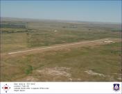
By: jcbecker@pie.mi...


