Login
Register


DAG
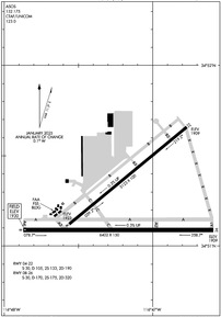
Barstow-Daggett Airport
Official FAA Data Effective 2026-01-22 0901Z
Chart Supplement

KDAG Airport Diagram
VFR Chart of KDAG
Sectional Charts at SkyVector.com
IFR Chart of KDAG
Enroute Charts at SkyVector.com
Location Information for KDAG
Coordinates: N34°51.22' / W116°47.20'Located 04 miles E of Daggett, California on 1087 acres of land. View all Airports in California.
Surveyed Elevation is 1930 feet MSL.
Operations Data
|
|
Airport Communications
| ASOS: | 132.175 Tel. 760-254-3630 |
|---|---|
| CTAF: | 123.000 |
| UNICOM: | 123.000 |
| ASOS at 1AF (30.4 N): | |
| AWOS-3 at VCV (33.1 SW): | 135.475 760-246-3635 |
| ATIS at VCV (33.2 SW): | 135.475 |
- APCH/DEP CTL SVC PRVDD BY LOS ANGELES ARTCC (ZLA) ON FREQS 132.5/284.7 (BARSTOW RCAG).
Nearby Navigation Aids
|
| ||||||||||||||||||||||||||||||||||||||||||


Runway 08/26
| Dimensions: | 6402 x 150 feet / 1951 x 46 meters | |
|---|---|---|
| Surface: | Asphalt in Fair Condition | |
| Weight Limits: | S-30, D-170, ST-320 | |
| Edge Lighting: | Medium Intensity | |
| Runway 08 | Runway 26 | |
| Coordinates: | N34°51.09' / W116°47.87' | N34°51.09' / W116°46.59' |
| Elevation: | 1930.0 | 1908.6 |
| Traffic Pattern: | Left | Left |
| Runway Heading: | 90° True | 270° True |
| Markings: | Basic in fair condition. | Basic in good condition. |
| Glide Slope Indicator | P4L (3.00° Glide Path Angle) | P4L (3.00° Glide Path Angle) |
Runway 04/22
| Dimensions: | 5123 x 100 feet / 1561 x 30 meters | |
|---|---|---|
| Surface: | Asphalt in Fair Condition | |
| Weight Limits: | S-30, D-105, ST-190 | |
| Edge Lighting: | Medium Intensity | |
| Runway 04 | Runway 22 | |
| Coordinates: | N34°51.12' / W116°47.56' | N34°51.66' / W116°46.77' |
| Elevation: | 1922.9 | 1908.7 |
| Traffic Pattern: | Left | Left |
| Runway Heading: | 51° True | 231° True |
| Markings: | Basic in fair condition. | Non-Precision Instrument in good condition. |
| Glide Slope Indicator | P4L (3.00° Glide Path Angle) | |
Services Available
| Fuel: | 100LL (blue), Jet-A |
|---|---|
| Transient Storage: | Tiedowns |
| Airframe Repair: | NOT AVAILABLE |
| Engine Repair: | NOT AVAILABLE |
| Bottled Oxygen: | NONE |
| Bulk Oxygen: | NONE |
Ownership Information
| Ownership: | Publicly owned | |
|---|---|---|
| Owner: | COUNTY OF SAN BERNARDINO | |
| 385 N ARROWHEAD AVE | ||
| SAN BERNARDINO, CA 92415 | ||
| 909-387-8810 | ||
| Manager: | MAUREEN SNELGROVE | |
| 268 HOSPITALITY LANE, SUITE 302 | ||
| SAN BERNARDINO, CA 92408 | ||
| 909-387-8810 | ||
Other Remarks
- E-W TWY PARALLEL TO RWY 08/26 WT BRG CPTY LIMITED TO S-12.
- PAEW INVOF ARMY RAMP. EXTSV MILITARY HELICOPTER TRAFFIC INVOF ARPT.
- FOR CD IF UNA TO CTC ON FSS FREQ, CTC LOS ANGELES ARTCC AT 661-575-2079.
- ACTVT MIRL RWY 4/22 & 8/26 - CTAF. PAPI RWY 08, 22, & 26 OPR CONSLY.
Weather Minimums

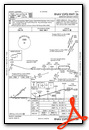
Instrument Approach Procedure (IAP) Charts


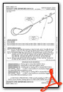
Departure Procedure Obstacles (DPO) Charts
Nearby Airports with Instrument Procedures
| ID | Name | Heading / Distance | ||
|---|---|---|---|---|
 |
KAPV | Apple Valley Airport | 229° | 25.9 |
|
KVCV | Southern California Logistics Airport | 242° | 33.3 |
|
L35 | Big Bear City Airport | 185° | 35.5 |
|
KREI | Redlands Municipal Airport | 201° | 49.4 |
|
KSBD | San Bernardino International Airport | 206° | 50.6 |
|
KEDW | Edwards AFB Airport | 273° | 54.3 |
|
KTNP | Twentynine Palms Airport | 135° | 60.1 |
|
KRIR | Flabob Airport | 211° | 60.3 |
|
KONT | Ontario International Airport | 220° | 62.6 |
|
KRIV | March Arb Airport | 202° | 62.8 |
|
KCCB | Cable Airport | 225° | 63.0 |
|
KPSP | Palm Springs International Airport | 167° | 62.9 |
Airport Images
Do you have a recent image of this airport? Upload it here!


