Login
Register


E40
Wilson's Airport
Official FAA Data Effective 2026-01-22 0901Z
Chart Supplement

VFR Chart of E40
Sectional Charts at SkyVector.com
IFR Chart of E40
Enroute Charts at SkyVector.com
Location Information for E40
Coordinates: N35°39.12' / W81°21.47'Located 04 miles S of Hickory, North Carolina on 27 acres of land. View all Airports in North Carolina.
Estimated Elevation is 985 feet MSL.
Operations Data
|
|
Airport Communications
| CTAF: | 122.900 |
|---|---|
| ASOS at HKY (5.5 N): | 118.325 828-322-2996 |
| AWOS-3 at IPJ (14.0 SE): | 119.675 704-735-6954 |
| AWOS-3P at MRN (16.1 NW): | 124.175 828-757-0788 |
Nearby Navigation Aids
|
| ||||||||||||||||||||||||||||||||||||||||||||||||||||||||||||


Runway 17/35
| Dimensions: | 2175 x 70 feet / 663 x 21 meters | |
|---|---|---|
| Surface: | Turf in Good Condition | |
| Runway 17 | Runway 35 | |
| Obstacles: | 26 ft Trees 50 ft from runway, 12 ft right of center CTLG OBSTN EXCEEDS A 45 DEG SLP. |
70 ft Trees 17 ft from runway, 90 ft left of center |
Services Available
| Fuel: | NONE |
|---|---|
| Transient Storage: | NONE |
| Airframe Repair: | NONE |
| Engine Repair: | NONE |
| Bottled Oxygen: | NONE |
| Bulk Oxygen: | NONE |
Ownership Information
| Ownership: | Privately Owned | |
|---|---|---|
| Owner: | WILLIAM WILSON | |
| 3442 NC HWY 127 SOUTH | ||
| HICKORY, NC 28602 | ||
| 828-217-3320 | ||
| Manager: | WILLIAM WILSON | |
| 3442 NC HWY 127 SOUTH | ||
| HICKORY, NC 28602 | ||
| 828-217-3320 | ||
Other Remarks
- 130 FT AGL UNMKD PLINES 1000 FT NORTH & EAST OF RWY AND UNMKD PLINES PARL TO EAST SIDE OF RWY 75 FT FM CNTRLN.
- RWY 35 SLOPES UPHILL. LAST HALF OF RWY 17 SLOPES DOWNHILL - THLD OF RWY 35 IS 6 FT LOWER THAN THLD OF RWY 17.
- WINDS PMTG TKOF RWY 17 AND LAND RWY 35.
- FOR CD CTC ATLANTA ARTCC AT 770-210-7692.
- RWY 35 LDG ACFT WILL TURN FINAL NORTH OF PLINES, ACFT ON STA WILL RMN ABV 1700 FT MSL UNTIL NORTH OF PLINES. ACFT DEPG SB CLIMB TO 1700 FT MSL BY PLINES OR INITIATE A XW TURN BEFORE REACHING PLINES.
- RWY 35 HAS 10 FT DROP-OFF 20 FT FR THR BOTH SIDES CNTRLN.
- RWY 17/35 MRKD BOTH ENDS WITH CONES INDICATING NON-PUBLD DSPLCD THLD.
- RWY 17/35 MKD WITH YELLOW CONES.
Nearby Airports with Instrument Procedures
| ID | Name | Heading / Distance | ||
|---|---|---|---|---|
 |
KHKY | Hickory Regional Airport | 343° | 5.6 |
|
KIPJ | Lincoln County Regional Airport | 136° | 14.0 |
|
KMRN | Foothills Regional Airport | 309° | 16.0 |
|
KSVH | Statesville Regional Airport | 070° | 20.9 |
|
14A | Lake Norman Airpark Airport | 095° | 22.5 |
|
KEHO | Shelby-Cleveland County Regional Airport | 206° | 26.6 |
|
KAKH | Gastonia Municipal Airport | 159° | 28.8 |
|
KFQD | Rutherford County/Marchman Field Airport | 244° | 31.3 |
|
KCLT | Charlotte/Douglas International Airport | 142° | 33.0 |
|
KJQF | Concord-Padgett Regional Airport | 116° | 35.5 |
|
KUKF | Wilkes County Airport | 020° | 36.5 |
|
KRUQ | Mid-Carolina Regional Airport | 090° | 41.0 |
Airport Images
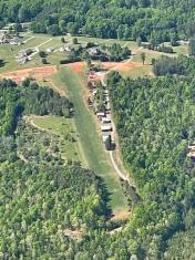
By: Big Orange Bird


