Login
Register


FKA
Fillmore County Airport
Official FAA Data Effective 2024-04-18 0901Z
Chart Supplement

VFR Chart of KFKA
Sectional Charts at SkyVector.com
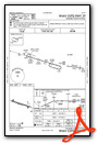
IFR Chart of KFKA
Enroute Charts at SkyVector.com
Location Information for KFKA
Coordinates: N43°40.60' / W92°10.78'Located 04 miles W of Preston, Minnesota on 90 acres of land. View all Airports in Minnesota.
Surveyed Elevation is 1276 feet MSL.
Operations Data
|
|
Airport Communications
| AWOS-3PT: | 118.550 Tel. 507-765-2182 |
|---|---|
| ROCHESTER APPROACH: | 119.8 251.125 |
| ROCHESTER DEPARTURE: | 119.8 251.125 |
| CTAF: | 122.900 |
| ASOS at RST (19.2 NW): | 507-424-8146 |
| ATIS at RST (19.6 NW): | 120.5 |
| AWOS-3PT at 9MN (24.4 NW): | 124.175 507-255-9417 |
- APCH/DEP SVC PRVDD BY MINNEAPOLIS ARTCC ON FREQS 132.35/307.3 (ROCHESTER RCAG) WHEN ROCHESTER APCH CTL CLSD.
Nearby Navigation Aids
|
| ||||||||||||||||||||||||||||||||||||||||||||||||||||||||||||


Runway 11/29
| Dimensions: | 4001 x 75 feet / 1220 x 23 meters | |
|---|---|---|
| Surface: | Asphalt in Good Condition | |
| Edge Lighting: | Medium Intensity | |
| Runway 11 | Runway 29 | |
| Coordinates: | N43°40.70' / W92°11.22' | N43°40.51' / W92°10.35' |
| Elevation: | 1272.8 | 1275.5 |
| Traffic Pattern: | Left | Left |
| Runway Heading: | 107° True | 287° True |
| Markings: | Non-Precision Instrument in good condition. | Non-Precision Instrument in good condition. |
| Glide Slope Indicator | P2L (3.00° Glide Path Angle) | P2L (3.00° Glide Path Angle) |
| REIL: | Yes | Yes |
Services Available
| Fuel: | 100LL (blue) |
|---|---|
| Transient Storage: | Tiedowns |
| Airframe Repair: | NONE |
| Engine Repair: | NONE |
| Bottled Oxygen: | NONE |
| Bulk Oxygen: | NONE |
| Other Services: | PILOT INSTRUCTION,AIRCRAFT RENTAL,AIRCRAFT SALES |
Ownership Information
| Ownership: | Publicly owned | |
|---|---|---|
| Owner: | FILLMORE COUNTY | |
| 909 HOUSTON ST NW | ||
| PRESTON, MN 55965-1080 | ||
| 507-765-3854 | ||
| Manager: | PAM SCHROEDER | |
| 909 HOUSTON ST NW | ||
| PRESTON, MN 55965-1080 | ||
| 507-765-3854 | ||
Operational Statistics
| Single Engine Aircraft Based on Field: | 26 | Statistics collected for 12 month period ending 2019-04-30 | |
|---|---|---|---|
| Multi-Engine Aircraft Based on Field: | none | Annual Commercial Operations: | none |
| Jet Aircraft Based on Field: | none | Annual Commuter Operations: | none |
| Helicopters Based on Field: | none | Annual Air Taxi Operations: | none |
| Military Aircraft Based on Field: | none | Annual Military Operations: | none |
| Gliders Based on Field: | none | Annual GA Local Operations: | 2040 |
| Ultralights Based on Field: | 1 | Annual GA Itinerant Operations: | 2040 |
Other Remarks
- ULTRALIGHTS ON & INVOF ARPT.
- FOR CD CTC ROCHESTER APCH AT 507-424-8111.
- 0LL FUEL AVBL H24 SELF SVC VIA CREDIT CARD.
- ACTVT REIL RWY 11 & 29; PAPI RWY 11 & 29; MIRL RWY 11/29 - CTAF.
Weather Minimums
Instrument Approach Procedure (IAP) Charts

Nearby Airports with Instrument Procedures
| ID | Name | Heading / Distance | ||
|---|---|---|---|---|
 |
55Y | Rushford Municipal/Robert W Bunke Field Airport | 061° | 17.3 |
|
KCJJ | Ellen Church Field Airport | 173° | 18.8 |
|
KRST | Rochester International Airport | 315° | 19.7 |
|
KCHU | Houston County Airport | 099° | 29.8 |
|
KDEH | Decorah Municipal Airport | 141° | 30.8 |
|
KONA | Winona Municipal-Max Conrad Field Airport | 039° | 31.6 |
|
KAUM | Austin Municipal Airport | 268° | 32.8 |
|
KTOB | Dodge Center Airport | 306° | 34.9 |
|
KCCY | Northeast Iowa Regional Airport | 207° | 40.9 |
|
KLSE | La Crosse Regional Airport | 072° | 41.9 |
|
3Y2 | George L Scott Municipal Airport | 157° | 44.8 |
|
KAEL | Albert Lea Municipal Airport | 270° | 51.7 |
Airport Images
Do you have a recent image of this airport? Upload it here!


