Login
Register


HBI
Asheboro Regional Airport
Official FAA Data Effective 2024-04-18 0901Z
Chart Supplement

VFR Chart of KHBI
Sectional Charts at SkyVector.com
IFR Chart of KHBI
Enroute Charts at SkyVector.com
Location Information for KHBI
Coordinates: N35°39.27' / W79°53.68'Located 06 miles SW of Asheboro, North Carolina on 454 acres of land. View all Airports in North Carolina.
Surveyed Elevation is 670 feet MSL.
Operations Data
|
|
Airport Communications
| AWOS-3: | 119.275 Tel. 336-626-7933 |
|---|---|
| GREENSBORO APPROACH: | 126.6 327.075 |
| GREENSBORO DEPARTURE: | 126.6 327.075 |
| UNICOM: | 122.800 |
| CTAF: | 122.800 |
| AWOS-3 at VUJ (19.0 SW): | 128.175 704-986-2097 |
| AWOS-3 at SCR (19.2 E): | 125.775 919-663-1252 |
| AWOS-3 at EXX (21.3 W): | 119.825 336-956-2967 |
Nearby Navigation Aids
|
| ||||||||||||||||||||||||||||||||||||||||||||||||||||||||||||


Runway 03/21
| Dimensions: | 5501 x 100 feet / 1677 x 30 meters | |
|---|---|---|
| Surface: | Asphalt in Good Condition | |
| Weight Limits: | S-30, D-60 | |
| Edge Lighting: | Medium Intensity | |
| Runway 03 | Runway 21 | |
| Coordinates: | N35°38.85' / W79°53.89' | N35°39.69' / W79°53.48' |
| Elevation: | 670.8 | 668.1 |
| Traffic Pattern: | Left | Left |
| Runway Heading: | 22° True | 202° True |
| Markings: | Non-Precision Instrument in good condition. | Non-Precision Instrument in good condition. |
| Glide Slope Indicator | P2L (3.50° Glide Path Angle) | P2L (3.00° Glide Path Angle) |
| REIL: | Yes | Yes |
| Obstacles: | 398 ft Trees 8976 ft from runway, 533 ft right of center | 40 ft Trees 1674 ft from runway, 292 ft right of center HAS 11 FT GND 0-200 FT FM THR 241 FT RIGHT OF CNTRLN. |
Services Available
| Fuel: | 100LL (blue), Jet A-1+ |
|---|---|
| Transient Storage: | Hangars,Tiedowns HGR IF AVBL. |
| Airframe Repair: | MAJOR |
| Engine Repair: | MAJOR |
| Bottled Oxygen: | NONE |
| Bulk Oxygen: | NONE |
| Other Services: | PILOT INSTRUCTION,AIRCRAFT RENTAL |
Ownership Information
| Ownership: | Publicly owned | |
|---|---|---|
| Owner: | CITY OF ASHEBORO | |
| P. O. BOX 1106 | ||
| ASHEBORO, NC 27204-1106 | ||
| 336-626-1201 | ||
| Manager: | RICHARD MCCRAW | |
| 2222 PILOTS VIEW RD | ||
| ASHEBORO, NC 27205-1106 | ||
| 336-625-6120 | FOR SVC AFTER HOURS CALL 919-357-7254. | |
Operational Statistics
| Single Engine Aircraft Based on Field: | 38 | Statistics collected for 12 month period ending 2021-04-02 | |
|---|---|---|---|
| Multi-Engine Aircraft Based on Field: | 4 | Annual Commercial Operations: | none |
| Jet Aircraft Based on Field: | none | Annual Commuter Operations: | none |
| Helicopters Based on Field: | none | Annual Air Taxi Operations: | none |
| Military Aircraft Based on Field: | none | Annual Military Operations: | 500 |
| Gliders Based on Field: | none | Annual GA Local Operations: | 8000 |
| Ultralights Based on Field: | none | Annual GA Itinerant Operations: | 7000 |
Other Remarks
- TERRAIN RISING SOUTH OF THE ARPT.
- RWY 03 HAS 40 FT DROP-OFF 400 FT FM THR; 0B.
- NORTH CAROLINA AVIATION MUSEUM HALL OF FAME LCTD ON FLD.
- FOR CD CTC GREENSBORO APCH AT 743-222-6129.
- 0LL 100LL 24 HR SELF SVC AVBL WITH CREDIT CARD.
- DUSK-2300; ACTVT REIL RWY 03 & 21; PAPI RWY 03 & 21; AND AFTER 2300, MIRL RWY 03/21 - CTAF.
Weather Minimums

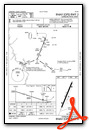
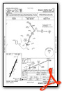
Instrument Approach Procedure (IAP) Charts
Nearby Airports with Instrument Procedures
| ID | Name | Heading / Distance | ||
|---|---|---|---|---|
 |
43A | Montgomery County Airport | 162° | 17.0 |
|
KVUJ | Stanly County Airport | 221° | 19.0 |
|
KSCR | Siler City Municipal Airport | 081° | 19.3 |
|
KEXX | Davidson County Exec Airport | 290° | 21.4 |
|
KGSO | Piedmont Triad International Airport | 355° | 26.9 |
|
KRUQ | Mid-Carolina Regional Airport | 269° | 30.6 |
|
KBUY | Burlington/Alamance Regional Airport | 040° | 31.4 |
|
8A7 | Twin Lakes Airport | 299° | 31.6 |
|
KINT | Smith Reynolds Airport | 331° | 32.8 |
|
KSOP | Moore County Airport | 135° | 35.2 |
|
KTTA | Raleigh Exec Jetport At Sanford-Lee County Airport | 096° | 39.1 |
|
KAFP | Anson County/Jeff Cloud Field Airport | 193° | 39.0 |
Airport Images

By: Big Orange Bird


