Login
Register


HQM
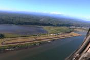
Bowerman Field Airport
Official FAA Data Effective 2025-12-25 0901Z
Chart Supplement

VFR Chart of KHQM
Sectional Charts at SkyVector.com
IFR Chart of KHQM
Enroute Charts at SkyVector.com
Location Information for KHQM
Coordinates: N46°58.27' / W123°56.19'Located 02 miles W of Hoquiam, Washington on 145 acres of land. View all Airports in Washington.
Surveyed Elevation is 17 feet MSL.
Operations Data
|
|
Airport Communications
| ASOS: | 135.775 Tel. 360-538-7021 |
|---|---|
| UNICOM: | 122.700 |
| CTAF: | 122.700 |
| ASOS at SHN (35.9 NE): | 119.275 360-358-3006 |
| ASOS at OLM (42.4 E): | 360-754-0781 |
| ATIS at OLM (42.4 E): | 135.725 |
- APCH/DEP CTL SVC PRVDD BY SEATTLE ARTCC (ZSE) ON FREQS 128.3/269.0 (HOQUIAM RCAG).
Nearby Navigation Aids
|
| ||||||||||||||||||||||||||||||||||||


Runway 06/24
| Dimensions: | 5000 x 150 feet / 1524 x 46 meters | |
|---|---|---|
| Surface: | Asphalt in Good Condition | |
| Weight Limits: | S-30, D-40, ST-80 | |
| Edge Lighting: | High Intensity | |
| Runway 06 | Runway 24 | |
| Coordinates: | N46°58.20' / W123°56.79' | N46°58.34' / W123°55.60' |
| Elevation: | 17.5 | 15.1 |
| Traffic Pattern: | Right | Left |
| Runway Heading: | 79° True | 259° True |
| Markings: | Non-Precision Instrument in fair condition. | Precision Instrument in fair condition. |
| Glide Slope Indicator | P4R (3.00° Glide Path Angle) | P4L (3.50° Glide Path Angle) |
| Approach Lights: | MALSR 1,400 Foot Medium-intensity Approach Lighting System with runway alignment indicator lights. | |
| REIL: | Yes | |
Services Available
| Fuel: | 100LL (blue), Jet-A |
|---|---|
| Transient Storage: | Tiedowns |
| Airframe Repair: | NONE |
| Engine Repair: | NONE |
| Bottled Oxygen: | NONE |
| Bulk Oxygen: | NONE |
| Other Services: | AIR AMBULANCE SERVICES |
Ownership Information
| Ownership: | Publicly owned | |
|---|---|---|
| Owner: | PORT OF GRAYS HARBOR | |
| BOX 660, 111 S WOODING STREET | ||
| ABERDEEN, WA 98520 | ||
| 360-533-9528 | ||
| Manager: | SHANNON ANDERSON | |
| BOX 660, 111 S WOODING STREET | ||
| ABERDEEN, WA 98520 | ||
| 360-533-9544 | AMGR CELL 360-310-0201. | |
Other Remarks
- THIS AIRPORT HAS BEEN SURVEYED BY THE NATIONAL GEODETIC SURVEY.
- <FLOCKS OF WATERFOWL ON AND IN VCNTY ARPT. CAUTION ADZD.
- SERVICE ROAD SOUTH OF RY IN PRIMARY SURFACE.
- ULTRALIGHTS PROHIBITED WITHOUT WRITTEN PERMISSON FROM ARPT MGR.
- 103 FT CRANE 0.2 NM SW OF AER RY 24.
- FOR CD IF UNA TO CTC ON FSS FREQ, CTC SEATTLE ARTCC AT 253-351-3694.
- 0LL 100LL AND JET A AVBL 24 HRS A DAY WITH MAJOR CREDIT CARD.
- ACTVT HIRL RY 06/24, PAPI RWY 06/24, MALSR RY 24 & REIL RY 06 - CTAF.
Weather Minimums

Instrument Approach Procedure (IAP) Charts


Nearby Airports with Instrument Procedures
| ID | Name | Heading / Distance | ||
|---|---|---|---|---|
 |
KSHN | Sanderson Field Airport | 063° | 36.0 |
|
KOLM | Olympia Regional Airport | 089° | 42.5 |
|
KCLS | Chehalis-Centralia Airport | 113° | 43.1 |
|
KAST | Astoria Regional Airport | 177° | 48.9 |
|
KTDO | Ed Carlson Memorial Field/South Lewis County Airport | 122° | 55.3 |
|
KGRF | Gray AAF (Joint Base Lewis-Mcchord) Airport | 082° | 56.0 |
|
KPWT | Bremerton Ntl Airport | 056° | 57.2 |
|
KTIW | Tacoma Narrows Airport | 071° | 58.4 |
|
KTCM | Mcchord Field (Joint Base Lewis-Mcchord) Airport | 079° | 60.7 |
|
KKLS | Southwest Washington Regional Airport | 139° | 66.9 |
|
KPLU | Pierce County/Thun Field Airport | 082° | 68.2 |
|
KCLM | William R Fairchild International Airport | 014° | 71.2 |