Login
Register


IWA
Mesa Gateway Airport
Official FAA Data Effective 2026-01-22 0901Z
From the Flight Deck
Chart Supplement

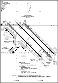
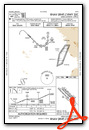
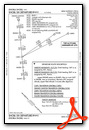
KIWA Airport Diagram
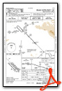
VFR Chart of KIWA
Sectional Charts at SkyVector.com
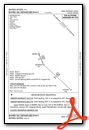
IFR Chart of KIWA
Enroute Charts at SkyVector.com
Location Information for KIWA
Coordinates: N33°18.47' / W111°39.33'Located 20 miles SE of Phoenix, Arizona on 3020 acres of land. View all Airports in Arizona.
Surveyed Elevation is 1384 feet MSL.
TPA FIXED WING 1218 FT AGL, JET 1718 FT AGL, ROTORCRAFT 718 FT AGL.
Operations Data
|
|
Airport Communications
| ATIS: | 133.5 270.275 |
|---|---|
| AWOS-3: | 133.5 Tel. 480-988-9428 |
| GATEWAY TOWER: | 120.6 289.4 |
| GATEWAY GROUND: | 128.25 275.8 |
| PHOENIX APPROACH: | 124.9 353.8 |
| PHOENIX DEPARTURE: | 124.9 353.8 |
| CLEARANCE DELIVERY: | 135.05 |
| SUNSS STAR: | 124.1 256.9 |
| EMERG: | 121.5 243.0 |
| HUUTY STAR: | 124.9 353.8 |
| DSERT STAR: | 120.7 |
| BLYTHE STAR: | 124.1 |
| CTAF: | 120.600 |
| AWOS-3PT at CHD (8.1 W): | 480-814-9952 |
| ATIS at CHD (8.2 W): | 128.325 |
| ATIS at FFZ (9.9 N): | 118.25 |
- ATCT OPERATED BY SERCO MGT SERVICES.
Nearby Navigation Aids
|
| ||||||||||||||||||||||||||||||||||||

Runway 12R/30L
| Dimensions: | 10401 x 150 feet / 3170 x 46 meters | |
|---|---|---|
| Surface: | Concrete in Good Condition | |
| Weight Limits: | S-55, D-95, ST-185, DT-550
PCR VALUE: 605/R/C/W/T
| |
| Edge Lighting: | Medium Intensity | |
| Runway 12R | Runway 30L | |
| Coordinates: | N33°19.06' / W111°40.37' | N33°17.84' / W111°38.94' |
| Elevation: | 1341.2 | 1374.2 |
| Traffic Pattern: | Right | Left |
| Runway Heading: | 136° True | 316° True |
| Declared Distances: | TORA:10401 TODA:10401 ASDA:10401 LDA:10401 | TORA:10401 TODA:10401 ASDA:10401 LDA:10401 |
| Markings: | Precision Instrument in good condition. | Precision Instrument in good condition. |
| Glide Slope Indicator | P4L (3.00° Glide Path Angle) | P4L (3.00° Glide Path Angle) |
Runway 12C/30C
| Dimensions: | 10201 x 150 feet / 3109 x 46 meters | |
|---|---|---|
| Surface: | Asphalt-Concrete in Good Condition | |
| Weight Limits: | S-55, D-95, ST-185, DT-550
PCR VALUE: 692/R/D/W/T
| |
| Edge Lighting: | High Intensity | |
| Runway 12C | Runway 30C | |
| Coordinates: | N33°19.06' / W111°39.96' | N33°17.86' / W111°38.55' |
| Elevation: | 1347.7 | 1380.5 |
| Traffic Pattern: | Left | |
| Runway Heading: | 136° True | 316° True |
| Declared Distances: | TORA:10201 TODA:10201 ASDA:10201 LDA:10201 | TORA:10201 TODA:10201 ASDA:10201 LDA:10201 |
| Markings: | Precision Instrument in good condition. | Precision Instrument in good condition. |
| Glide Slope Indicator | P4L (3.00° Glide Path Angle) | P4L (3.00° Glide Path Angle) |
Runway 12L/30R
| Dimensions: | 9300 x 150 feet / 2835 x 46 meters | |
|---|---|---|
| Surface: | Concrete in Good Condition | |
| Weight Limits: | S-75, D-210, ST-590, DT-850
PCR VALUE: 858/R/C/W/T
| |
| Edge Lighting: | High Intensity | |
| Runway 12L | Runway 30R | |
| Coordinates: | N33°19.06' / W111°39.68' | N33°17.96' / W111°38.40' |
| Elevation: | 1356.3 | 1384.1 |
| Traffic Pattern: | Left | Right |
| Runway Heading: | 136° True | 316° True |
| Declared Distances: | TORA:9300 TODA:9300 ASDA:9300 LDA:9300 | TORA:9300 TODA:9300 ASDA:9300 LDA:9300 |
| Markings: | Precision Instrument in good condition. | Precision Instrument in good condition. |
| Glide Slope Indicator | P4L (3.00° Glide Path Angle) | P4L (3.00° Glide Path Angle) |
| REIL: | Yes | Yes |
Services Available
| Fuel: | 100LL (blue), Jet-A |
|---|---|
| Transient Storage: | Hangars,Tiedowns |
| Airframe Repair: | MINOR |
| Engine Repair: | MAJOR |
| Bottled Oxygen: | HIGH/LOW |
| Bulk Oxygen: | NOT AVAILABLE |
| Other Services: | AIR AMBULANCE SERVICES,AVIONICS,CARGO HANDLING SERVICES,CHARTER SERVICE,PILOT INSTRUCTION,AIRCRAFT RENTAL |
Ownership Information
| Ownership: | Publicly owned | |
|---|---|---|
| Owner: | MESA GATEWAY ARPT AUTH | |
| 5835 S. SOSSAMAN RD | ||
| MESA, AZ 85212-0919 | ||
| 480-988-7570 | ||
| Manager: | IVAN SMITH | |
| 5835 S. SOSSAMAN ROAD | ||
| MESA, AZ 85212-0919 | ||
| 480-988-7708 | ||
Other Remarks
- NOISE ABATEMENT PROC IN EFCT; AVOID LOW OVR FLT OF NOISE SENSITIVE AREAS SRNDG ARPT.
- TWY Y RSTD TO WINGSPAN LESS THAN 79 FT.
- 7 FT FENCE S PORTION OF TWY W APRON.
- LRG/HVY INBOARD ENGINE TAX ONLY.
- NON EMERG AV-8 MODEL OPS LMTD TO RWY 12L/30R.
- 24 HR PPR FOR UNSKED ACR GTR THAN 30 PAX SEATS - ARPT OPS.
- FOR CD WHEN ATCT CLSD, CTC PHOENIX APCH AT 602-306-2565.
- FUEL AVBL H24 - 480-988-7700 OR 129.875.
- WILDLIFE INVOF ARPT.
- SPORT FIELD LGTG E OF APCH.
- WHEN ATCT CLSD LGTS ON CONSLY.
- TPA FIXED WING 1218 FT AGL, JET 1718 FT AGL, ROTORCRAFT 718 FT AGL.
Weather Minimums

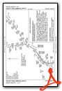
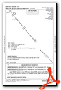
Standard Terminal Arrival (STAR) Charts

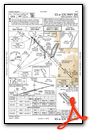
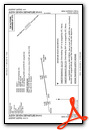
Instrument Approach Procedure (IAP) Charts


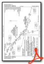
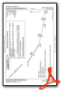
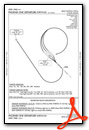
Departure Procedure (DP) Charts

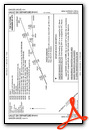

Departure Procedure Obstacles (DPO) Charts
Nearby Airports with Instrument Procedures
| ID | Name | Heading / Distance | ||
|---|---|---|---|---|
 |
KCHD | Chandler Municipal Airport | 253° | 8.2 |
|
KFFZ | Falcon Field Airport | 338° | 9.9 |
|
P19 | Stellar Airpark Airport | 267° | 13.1 |
|
KPHX | Phoenix Sky Harbor International Airport | 293° | 19.4 |
|
KCGZ | Casa Grande Municipal Airport | 194° | 21.9 |
|
KSDL | Scottsdale Airport | 325° | 22.8 |
|
P08 | Coolidge Municipal Airport | 152° | 25.1 |
|
KDVT | Phoenix Deer Valley Airport | 316° | 31.3 |
|
KGEU | Glendale Regional Airport | 292° | 34.7 |
|
KGYR | Phoenix Goodyear Airport | 281° | 36.8 |
|
KLUF | Luke AFB Airport | 290° | 39.0 |
|
P13 | San Carlos Apache Airport | 086° | 49.7 |
Fuel Providers


We proudly offer fuel from:

US Dollar per US Gallon
Price Guaranteed by FBO
Airport Images
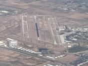
By: Big Orange Bird


