Login
Register


MMI
Mcminn County Airport
Official FAA Data Effective 2024-04-18 0901Z
Chart Supplement

VFR Chart of KMMI
Sectional Charts at SkyVector.com
IFR Chart of KMMI
Enroute Charts at SkyVector.com
Location Information for KMMI
Coordinates: N35°23.95' / W84°33.71'Located 03 miles SE of Athens, Tennessee on 210 acres of land. View all Airports in Tennessee.
Estimated Elevation is 874 feet MSL.
Operations Data
|
|
Airport Communications
| AWOS-3: | 125.425 Tel. 423-745-3422 |
|---|---|
| KNOXVILLE APPROACH: | 123.9 353.6 |
| KNOXVILLE DEPARTURE: | 123.9 353.6 |
| UNICOM: | 122.800 |
| CTAF: | 122.800 |
| AWOS-3 at MNV (12.4 NE): | 118.475 423-442-6170 |
| AWOS-3 at RZR (16.4 SW): | 120.475 423-479-6823 |
| AWOS-3 at 2A0 (18.8 W): | 135.075 423-775-4695 |
Nearby Navigation Aids
|
| ||||||||||||||||||||||||||||||||||||||||||||||||||||||||||||


Runway 02/20
| Dimensions: | 6450 x 100 feet / 1966 x 30 meters | |
|---|---|---|
| Surface: | Asphalt in Good Condition | |
| Weight Limits: | 15 /F/D/X/T, S-30, D-42 | |
| Edge Lighting: | Medium Intensity | |
| Runway 02 | Runway 20 | |
| Coordinates: | N35°23.45' / W84°33.92' | N35°24.45' / W84°33.50' |
| Elevation: | 806.5 | 874.3 |
| Traffic Pattern: | Left | Left |
| Runway Heading: | 19° True | 199° True |
| Displaced Threshold: | 949 Feet | |
| Markings: | Non-Precision Instrument in poor condition. | Non-Precision Instrument in poor condition. |
| Glide Slope Indicator | P2L (3.00° Glide Path Angle) PAPI UNUSBL BYD 7 DEGS LEFT OF CNTRLN. | P2L (3.00° Glide Path Angle) |
| REIL: | Yes | Yes |
| Obstacles: | 74 ft Trees 1189 ft from runway, 137 ft left of center APCH SLOPE 36:1 TO DTHR. |
68 ft Trees 1522 ft from runway, 157 ft left of center |
Services Available
| Fuel: | 100LL (blue), Jet A+ |
|---|---|
| Transient Storage: | Hangars,Tiedowns |
| Airframe Repair: | NOT AVAILABLE |
| Engine Repair: | NOT AVAILABLE |
| Bottled Oxygen: | NOT AVAILABLE |
| Bulk Oxygen: | NOT AVAILABLE |
| Other Services: | PILOT INSTRUCTION |
Ownership Information
| Ownership: | Publicly owned | |
|---|---|---|
| Owner: | MCMINN COUNTY | |
| COUNTY COURTHOUSE, 6 EAST MADISON AVENUE | ||
| ATHENS, TN 37303 | ||
| 423-745-7634 | ||
| Manager: | KRISTY GENTRY COX | |
| 195 COUNTY ROAD 552 | ||
| ATHENS, TN 37303 | ||
| 423-745-4939 | ||
Operational Statistics
| Single Engine Aircraft Based on Field: | 35 | Statistics collected for 12 month period ending 2023-06-22 | |
|---|---|---|---|
| Multi-Engine Aircraft Based on Field: | 2 | Annual Commercial Operations: | none |
| Jet Aircraft Based on Field: | 1 | Annual Commuter Operations: | none |
| Helicopters Based on Field: | 1 | Annual Air Taxi Operations: | 1500 |
| Military Aircraft Based on Field: | none | Annual Military Operations: | 75 |
| Gliders Based on Field: | none | Annual GA Local Operations: | 15000 |
| Ultralights Based on Field: | none | Annual GA Itinerant Operations: | 6000 |
Other Remarks
- WILDLIFE ON & INVOF ARPT.
- FOR CD CTC KNOXVILLE APCH AT 865-980-3034; IF UNA FOR CD CTC KNOXVILLE APCH AT 865-980-3033.
- FADED.
- FADED.
Weather Minimums
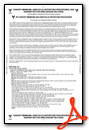
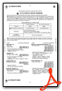
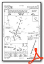
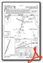
Instrument Approach Procedure (IAP) Charts
Nearby Airports with Instrument Procedures
| ID | Name | Heading / Distance | ||
|---|---|---|---|---|
 |
KMNV | Monroe County Airport | 045° | 12.5 |
|
KRZR | Cleveland Regional Jetport Airport | 226° | 16.2 |
|
2A0 | Mark Anton Airport | 286° | 18.8 |
|
1A3 | Martin Campbell Field Airport | 155° | 25.3 |
|
KRKW | Rockwood Municipal Airport | 348° | 32.0 |
|
KRHP | Western Carolina Regional Airport | 109° | 36.4 |
|
KTYS | Mc Ghee Tyson Airport | 048° | 37.2 |
|
KCHA | Lovell Field Airport | 235° | 38.4 |
|
KCSV | Crossville Memorial-Whitson Field Airport | 322° | 41.8 |
|
KDZJ | Blairsville Airport | 139° | 42.9 |
|
KDNN | Dalton Municipal Airport | 200° | 43.3 |
|
49A | Gilmer County Airport | 177° | 46.2 |
Airport Images
Do you have a recent image of this airport? Upload it here!


