Login
Register


MNV
Monroe County Airport
Official FAA Data Effective 2024-04-18 0901Z
Chart Supplement

VFR Chart of KMNV
Sectional Charts at SkyVector.com
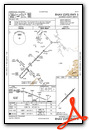
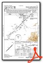
IFR Chart of KMNV
Enroute Charts at SkyVector.com
Location Information for KMNV
Coordinates: N35°32.71' / W84°22.82'Located 02 miles NW of Madisonville, Tennessee on 112 acres of land. View all Airports in Tennessee.
Surveyed Elevation is 1031 feet MSL.
Operations Data
|
|
Airport Communications
| AWOS-3: | 118.475 Tel. 423-442-6170 |
|---|---|
| KNOXVILLE APPROACH: | 123.9 353.6 |
| KNOXVILLE DEPARTURE: | 123.9 353.6 |
| CTAF: | 123.000 |
| UNICOM: | 123.000 |
| AWOS-3 at MMI (12.6 SW): | 125.425 423-745-3422 |
| ATIS at TYS (24.7 NE): | 128.35 |
| ASOS at TYS (25.3 NE): | 865-981-4053 |
Nearby Navigation Aids
|
| ||||||||||||||||||||||||||||||||||||||||||||||||||||||||||||


Runway 05/23
| Dimensions: | 3643 x 75 feet / 1110 x 23 meters | |
|---|---|---|
| Surface: | Asphalt in Good Condition | |
| Weight Limits: | S-22, D-35 | |
| Edge Lighting: | Medium Intensity | |
| Runway 05 | Runway 23 | |
| Coordinates: | N35°32.50' / W84°23.08' | N35°32.93' / W84°22.57' |
| Elevation: | 1030.2 | 1000.8 |
| Traffic Pattern: | Left | Left |
| Runway Heading: | 44° True | 224° True |
| Displaced Threshold: | 140 Feet | |
| Markings: | Non-Precision Instrument in good condition. | Non-Precision Instrument in good condition. |
| REIL: | Yes | Yes |
Services Available
| Fuel: | 100LL (blue), Jet A-1+ |
|---|---|
| Transient Storage: | Tiedowns |
| Airframe Repair: | MAJOR |
| Engine Repair: | MAJOR |
| Bottled Oxygen: | NOT AVAILABLE |
| Bulk Oxygen: | NOT AVAILABLE |
| Other Services: | PILOT INSTRUCTION,AIRCRAFT RENTAL |
Ownership Information
| Ownership: | Publicly owned | |
|---|---|---|
| Owner: | MONROE COUNTY | |
| MONROE CO COURTHOUSE, 105 COLLEGE STREET, SUITE 1 | ||
| MADISONVILLE, TN 37354 | ||
| 423-442-3981 | ||
| Manager: | TOM MCCOSH | |
| 105 COLLEGE STREET, SUITE 1 | ||
| MADISONVILLE, TN 37354 | ||
| 423-420-0563 | ||
Operational Statistics
| Single Engine Aircraft Based on Field: | 34 | Statistics collected for 12 month period ending 2017-04-30 | |
|---|---|---|---|
| Multi-Engine Aircraft Based on Field: | 2 | Annual Commercial Operations: | none |
| Jet Aircraft Based on Field: | none | Annual Commuter Operations: | none |
| Helicopters Based on Field: | none | Annual Air Taxi Operations: | 50 |
| Military Aircraft Based on Field: | none | Annual Military Operations: | 500 |
| Gliders Based on Field: | none | Annual GA Local Operations: | 42000 |
| Ultralights Based on Field: | none | Annual GA Itinerant Operations: | 3600 |
Other Remarks
- FOR CD CTC KNOXVILLE APCH AT 865-980-3034; IF UNA FOR CD CTC KNOXVILLE APCH AT 865-980-3033.
- REIL RWY 5 & 23 SS-SR.
Weather Minimums
Instrument Approach Procedure (IAP) Charts
Nearby Airports with Instrument Procedures
| ID | Name | Heading / Distance | ||
|---|---|---|---|---|
 |
KMMI | Mcminn County Airport | 225° | 12.5 |
|
KTYS | Mc Ghee Tyson Airport | 049° | 24.7 |
|
2A0 | Mark Anton Airport | 262° | 27.2 |
|
KRKW | Rockwood Municipal Airport | 326° | 27.2 |
|
KRZR | Cleveland Regional Jetport Airport | 225° | 28.6 |
|
1A3 | Martin Campbell Field Airport | 177° | 31.8 |
|
KRHP | Western Carolina Regional Airport | 129° | 32.9 |
|
KDKX | Knoxville Downtown Island Airport | 044° | 35.2 |
|
KCSV | Crossville Memorial-Whitson Field Airport | 305° | 42.1 |
|
KDZJ | Blairsville Airport | 155° | 45.5 |
|
KGKT | Gatlinburg-Pigeon Forge Airport | 065° | 45.6 |
|
KJAU | Colonel Tommy C Stiner Airfield Airport | 012° | 48.4 |

 KMNV from SE, 3500' MSL")


