Login
Register


OZW
Livingston County/Spencer J Hardy Airport
Official FAA Data Effective 2026-02-19 0901Z
Chart Supplement

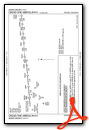
VFR Chart of KOZW
Sectional Charts at SkyVector.com
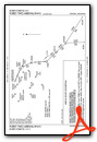
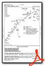
IFR Chart of KOZW
Enroute Charts at SkyVector.com
Location Information for KOZW
Coordinates: N42°37.77' / W83°58.93'Located 03 miles NW of Howell, Michigan on 217 acres of land. View all Airports in Michigan.
Surveyed Elevation is 962 feet MSL.
Operations Data
|
|
Airport Communications
| AWOS-3P: | 118.875 Tel. 517-546-4450 |
|---|---|
| DETROIT APPROACH: | 132.35 284.0 |
| DETROIT DEPARTURE: | 132.35 284.0 |
| CLEARANCE DELIVERY: | 121.725 |
| CTAF: | 123.000 |
| UNICOM: | 123.000 |
| AWOS-3P at TEW (19.8 W): | 119.425 517-676-5607 |
| ASOS at FNT (22.7 NE): | 810-202-2914 |
| ATIS at FNT (22.7 NE): | 133.15 |
- FOR CD KEY FREQ 121.725 4 TIMES. TO CONTACT FSS KEY FREQ 121.725 6 TIMES; ONE SECOND ON/ONE SECOND OFF; MONITOR 121.725 WHILE ELECTRONIC EQUIP DIALS DET CD/LANSING FSS.
Nearby Navigation Aids
|
| ||||||||||||||||||||||||||||||||||||||||||||||||||||||||||||


Runway 13/31
| Dimensions: | 5002 x 100 feet / 1525 x 30 meters | |
|---|---|---|
| Surface: | Concrete / Grooved in Good Condition | |
| Weight Limits: | S-100 | |
| Edge Lighting: | High Intensity | |
| Runway 13 | Runway 31 | |
| Coordinates: | N42°38.02' / W83°59.37' | N42°37.52' / W83°58.49' |
| Elevation: | 962.0 | 943.2 |
| Traffic Pattern: | Left | Left |
| Runway Heading: | 127° True | 307° True |
| Markings: | Precision Instrument in good condition. | Precision Instrument in good condition. |
| Glide Slope Indicator | P4L (3.00° Glide Path Angle) | P4L (3.00° Glide Path Angle) |
| Approach Lights: | MALSR 1,400 Foot Medium-intensity Approach Lighting System with runway alignment indicator lights. | |
| REIL: | Yes | |
| Obstacles: | 58 ft Tree 1313 ft from runway, 650 ft right of center | 40 ft Tree 471 ft from runway, 550 ft right of center |
Services Available
| Fuel: | 100LL (blue), Jet-A, Jet A+ |
|---|---|
| Transient Storage: | Hangars,Tiedowns |
| Airframe Repair: | MAJOR |
| Engine Repair: | MAJOR |
| Bottled Oxygen: | NOT AVAILABLE |
| Bulk Oxygen: | NOT AVAILABLE |
| Other Services: | AIR AMBULANCE SERVICES,CHARTER SERVICE,PILOT INSTRUCTION,AIRCRAFT RENTAL |
Ownership Information
| Ownership: | Publicly owned | |
|---|---|---|
| Owner: | LIVINGSTON COUNTY | |
| 3399 COUNTY AIRPORT DR | ||
| HOWELL, MI 48855 | ||
| 517-546-3520 | ||
| Manager: | MARK D JOHNSON | |
| 3399 COUNTY AIRPORT DR | ||
| HOWELL, MI 48855 | ||
| 517-546-6675 | ||
Other Remarks
- DEER & LRG BIRDS ON & INVOF ARPT.
- GCO AVBL ON FREQ 121.725 THRU DTW CLNC DEL & FLT SVCS.
- FOR CD CTC DETROIT APCH AT 734-955-1404.
- ACTVT OR INCR INTST MALSR RWY 13; REIL RWY 31; HIRL RWY 13/31 - CTAF. PAPI RWY 13 & 31 OPR CONSLY DAWN-DUSK; HIRL RWY 13/31 PRESET LOW INTST DUSK-2200.
Weather Minimums


Standard Terminal Arrival (STAR) Charts

Instrument Approach Procedure (IAP) Charts


Departure Procedure (DP) Charts


Nearby Airports with Instrument Procedures
| ID | Name | Heading / Distance | ||
|---|---|---|---|---|
 |
9G2 | Prices Airport | 041° | 14.3 |
|
Y47 | Oakland Southwest Airport | 115° | 17.6 |
|
KTEW | Mason Jewett Field Airport | 259° | 19.9 |
|
KFNT | Bishop International Airport | 027° | 22.7 |
|
KRNP | Owosso Community Airport | 342° | 22.9 |
|
KPTK | Oakland County International Airport | 084° | 25.0 |
|
KARB | Ann Arbor Municipal Airport | 156° | 26.5 |
|
KLAN | Capital Region International Airport | 288° | 28.2 |
|
1D2 | Canton-Plymouth-Mettetal Airport | 125° | 28.8 |
|
KJXN | Jackson County/Reynolds Field Airport | 224° | 30.7 |
|
KYIP | Willow Run Airport | 139° | 30.8 |
|
4D0 | Abrams Municipal Airport | 284° | 34.3 |
Airport Images

By: 15zenderb


