Login
Register


PIE
St Pete-Clearwater International Airport
Official FAA Data Effective 2025-12-25 0901Z
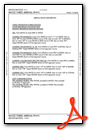
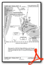
From the Flight Deck
Chart Supplement

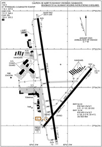
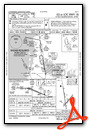
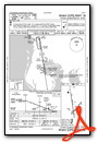
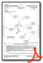
KPIE Airport Diagram
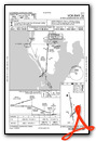
VFR Chart of KPIE
Sectional Charts at SkyVector.com
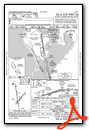
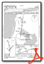
IFR Chart of KPIE
Enroute Charts at SkyVector.com
Location Information for KPIE
Coordinates: N27°54.52' / W82°41.19'Located 08 miles N of St Petersburg-Clearwater, Florida on 1900 acres of land. View all Airports in Florida.
Surveyed Elevation is 10 feet MSL.
Operations Data
|
|
Airport Communications
| ATIS: | 134.5 |
|---|---|
| ASOS: | 134.5 Tel. 727-502-6385 |
| ST. PETERSBURG-CLEARWATER TOWER: | 118.3 128.4 257.8 |
| ST. PETERSBURG-CLEARWATER GROUND: | 121.9 348.6 |
| TAMPA APPROACH: | 125.3 316.05 |
| TAMPA DEPARTURE: | 125.3 316.05 |
| CLEARANCE DELIVERY: | 120.6 350.2 |
| UNICOM: | 122.950 |
| BLFRG STAR: | 119.65 353.575 |
| BAYPO DP: | 125.3 316.05 |
| LLRGO DP: | 125.3 316.05 |
| RAYZZ STAR: | 118.8 239.3 |
| CTAF: | 118.300 |
| ENDED DP: | 125.3 316.05 |
| DADES STAR: | 135.5 279.6 |
| BANGZ STAR: | 118.8 239.3 |
| AWOS-3P at CLW (5.4 NW): | 119.225 727-462-6383 |
| ASOS at TPA (8.4 E): | 126.45 813-296-2752 |
| ASOS at SPG (9.0 S): | 118.875 727-821-4334 |
Nearby Navigation Aids
|
| ||||||||||||||||||||||||||||||||||||||||||


Runway 18/36
| Dimensions: | 9730 x 150 feet / 2966 x 46 meters | |
|---|---|---|
| Surface: | Asphalt / Grooved in Excellent Condition | |
| Weight Limits: | S-120, D-218, ST-413, DT-866
PCR VALUE: 490/F/A/X/T
| |
| Edge Lighting: | High Intensity | |
| Runway 18 | Runway 36 | |
| Coordinates: | N27°55.40' / W82°41.44' | N27°53.82' / W82°41.17' |
| Elevation: | 6.6 | 9.8 |
| Traffic Pattern: | Left | Left |
| Runway Heading: | 171° True | 351° True |
| Displaced Threshold: | 930 Feet | |
| Declared Distances: | TORA:9730 TODA:9730 ASDA:9180 LDA:9180 | TORA:9730 TODA:9730 ASDA:9650 LDA:8720 |
| Markings: | Precision Instrument in fair condition. | Precision Instrument in fair condition. |
| Glide Slope Indicator | P4L (3.00° Glide Path Angle) | P4L (3.00° Glide Path Angle) |
| RVR Equipment | Touchdown Midfield Rollout | Touchdown Midfield Rollout |
| Approach Lights: | MALSR 1,400 Foot Medium-intensity Approach Lighting System with runway alignment indicator lights. | |
| Centerline Lights: | Yes | Yes |
| Obstacles: | 9 ft Brush 665 ft from runway, 280 ft right of center | 30 ft Tree 450 ft from runway, 425 ft left of center APCH RATIO 50:1 TO DTHR. 6 FT FENCE 200 FT BFR AER 483 FT R OF CNTRLN. |
Runway 04/22
| Dimensions: | 6000 x 150 feet / 1829 x 46 meters | |
|---|---|---|
| Surface: | Asphalt / Grooved in Fair Condition | |
| Weight Limits: | S-91, D-153, ST-252
PCR VALUE: 360/F/B/X/T
| |
| Edge Lighting: | Medium Intensity | |
| Runway 04 | Runway 22 | |
| Coordinates: | N27°53.99' / W82°41.36' | N27°54.75' / W82°40.65' |
| Elevation: | 10.7 | 5.1 |
| Traffic Pattern: | Left | Left |
| Runway Heading: | 40° True | 220° True |
| Declared Distances: | TORA:6000 TODA:6000 ASDA:6000 LDA:6000 | TORA:6000 TODA:6000 ASDA:6000 LDA:6000 |
| Markings: | Non-Precision Instrument in good condition. | Non-Precision Instrument in good condition. |
| Glide Slope Indicator | P4L (3.00° Glide Path Angle) | P4L (3.00° Glide Path Angle) |
| REIL: | Yes | Yes |
| Obstacles: | 32 ft Trees 1135 ft from runway, 10 ft left of center | 8 ft Road 270 ft from runway, 250 ft left of center APCH RATIO 34:1 TO THR. |
Services Available
| Fuel: | 100 (green), Jet-A, Jet A-1+ |
|---|---|
| Transient Storage: | Hangars,Tiedowns |
| Airframe Repair: | MAJOR |
| Engine Repair: | MAJOR |
| Bottled Oxygen: | NONE |
| Bulk Oxygen: | HIGH/LOW |
| Other Services: | AIR FREIGHT SERVICES,AIR AMBULANCE SERVICES,CHARTER SERVICE,PILOT INSTRUCTION,AIRCRAFT RENTAL |
Ownership Information
| Ownership: | Publicly owned | |
|---|---|---|
| Owner: | COUNTY OF PINELLAS | |
| ST. PETE-CLEARWATER INTERNATIONAL, 14700 TERMINAL BLVD. SUITE 221 | ||
| CLEARWATER, FL 33762 | ||
| 727-453-7800 | ||
| Manager: | MARK SPRAGUE | |
| ST PETE-CLEARWATER INTERNATIONAL | ||
| CLEARWATER, FL 33762 | ||
| 727-453-7800 | ||
Other Remarks
- BANNER TOWING NA.
- BIRDS ON & INVOF ARPT.
- FOR CD IF UNA TO CTC ON FSS FREQ, CTC TAMPA APCH AT 813-878-2528.
- PPR RQRD FOR ALL TRANS ACFT REQUESTING TO PRK ON CLEARWATER USAR MIL RAMP/APRON. MUST CTC CLEARWATER ARMY SUPPORT FAC OPS AT (910)-771-3046 OR ASF MACDILL AT (813)-828-3183/3180 UP TO 7 DAYS BFR ARR. MIN NOTICE IS 24 HOURS BFR ARR. 1000Z-0300Z M-TH OR FRI 1000Z-1830Z EXCLUDING HOLIDAYS & WEEKENDS.
- NOISE SENSITIVE AREA 5 MI N EXTDG 1 MI E & W OF LOC SB TO SHORELINE.
- MILITARY: CONTRACT AVOIL O-128 AVBL.
- TBJT LNDG RWY 18 & DEP RWY 36 USE PUBLD NOISE ABATEMENT PROC.
- LGTS ON HWY N OF ARPT MAY BE MISTAKEN FOR RWY LGTS.
- WHEN ATCT CLSD ACTVT MALSR RWY 18; TDZ RWY 18; CNTLN RWY 18/36; MIRL RWY 04/22; HIRL RWY 18/36; TWY LGTS - CTAF.
Weather Minimums
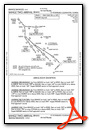
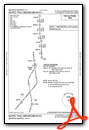
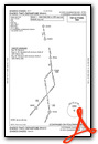
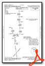
Standard Terminal Arrival (STAR) Charts
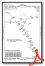

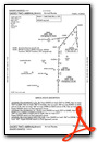

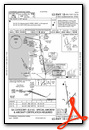
Instrument Approach Procedure (IAP) Charts


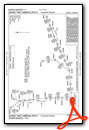
Departure Procedure (DP) Charts


Nearby Airports with Instrument Procedures
| ID | Name | Heading / Distance | ||
|---|---|---|---|---|
 |
KCLW | Clearwater Exec Airport | 316° | 5.6 |
|
KTPA | Tampa International Airport | 063° | 9.1 |
|
KSPG | Albert Whitted Airport | 159° | 9.2 |
|
KMCF | Macdill AFB Airport | 111° | 9.5 |
|
KTPF | Peter O Knight Airport | 088° | 12.6 |
|
KVDF | Tampa Exec Airport | 070° | 19.2 |
|
KPCM | Plant City Airport | 078° | 28.3 |
|
KSRQ | Sarasota/Bradenton International Airport | 167° | 31.5 |
|
KZPH | Zephyrhills Municipal Airport | 055° | 34.0 |
|
KLAL | Lakeland Linder International Airport | 082° | 35.8 |
|
KBKV | Brooksville-Tampa Bay Regional Airport | 019° | 35.9 |
|
KBOW | Bartow Exec Airport | 087° | 48.0 |
Fuel Providers


We proudly offer fuel from:

US Dollar per US Gallon
Price Guaranteed by FBO
Airport Images
Do you have a recent image of this airport? Upload it here!


