Login
Register
PN98
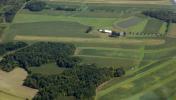
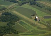
Dream Field Airport
Official FAA Data Effective 2025-12-25 0901Z
VFR Chart of PN98
Sectional Charts at SkyVector.com
IFR Chart of PN98
Enroute Charts at SkyVector.com
Location Information for PN98
Coordinates: N39°55.97' / W78°56.05'Located 01 miles NE of Berlin, Pennsylvania on 5 acres of land. View all Airports in Pennsylvania.
Estimated Elevation is 2321 feet MSL.
Operations Data
|
|
Airport Communications
| AWOS-3P at 2G9 (7.5 NW): | 133.8 814-443-2114 |
|---|---|
| AWOS-3 at CBE (20.5 SE): | 128.625 304-738-0451 |
| AWOS-3 at HMZ (21.3 NE): | 123.675 814-623-2936 |
Nearby Navigation Aids
|
| ||||||||||||||||||||||||||||||||||||||||||
Runway 15/33
| Dimensions: | 2240 x 100 feet / 683 x 30 meters | |
|---|---|---|
| Surface: | Turf | |
| Runway 15 | Runway 33 | |
Ownership Information
| Ownership: | Privately Owned | |
|---|---|---|
| Owner: | MICHAEL D. BAKER | |
| 4498 HUCKLEBERRY HWY | ||
| BERLIN, PA 15530 | ||
| 814-279-2507 | ||
| Manager: | MICHAEL D. BAKER | |
| 4498 HUCKLEBERRY HWY | ||
| BERLIN, PA 15530 | ||
| 814-279-2507 | ||
Other Remarks
- RY MKD WITH YELLOW CONES EVERY 200 FT.
- FOR CD CTC JOHNSTOWN APCH AT 814-532-5960, WHEN APCH CLSD CTC CLEVELAND ARTCC AT 440-774-0234.
Nearby Airports with Instrument Procedures
| ID | Name | Heading / Distance | ||
|---|---|---|---|---|
 |
2G9 | Somerset County Airport | 329° | 7.4 |
 |
KCBE | Greater Cumberland Regional Airport | 157° | 20.6 |
 |
KHMZ | Bedford County Airport | 064° | 21.5 |
 |
KJST | John Murtha Johnstown/Cambria County Airport | 011° | 23.4 |
 |
2G4 | Garrett County Airport | 221° | 28.1 |
 |
KLBE | Arnold Palmer Regional Airport | 313° | 29.9 |
 |
9G8 | Ebensburg Airport | 012° | 32.5 |
 |
KVVS | Joseph A Hardy Connellsville Airport | 272° | 33.4 |
 |
KAOO | Altoona/Blair County Airport | 052° | 35.7 |
 |
W35 | Potomac Airpark Airport | 111° | 38.3 |
 |
KIDI | Indiana County/Jimmy Stewart Field Airport | 349° | 42.6 |
 |
KFWQ | Rostraver Airport | 292° | 44.5 |


