Login
Register


PS03
Elephant Path Airport
Official FAA Data Effective 2025-12-25 0901Z
VFR Chart of PS03
Sectional Charts at SkyVector.com
IFR Chart of PS03
Enroute Charts at SkyVector.com
Location Information for PS03
Coordinates: N40°24.47' / W75°13.95'Located 04 miles NE of Perkasie, Pennsylvania on 86 acres of land. View all Airports in Pennsylvania.
Estimated Elevation is 370 feet MSL.
Operations Data
|
|
Airport Communications
| AWOS-3 at CKZ (3.1 SW): | 126.325 215-257-7291 |
|---|---|
| ASOS at DYL (6.7 SE): | 118.875 215-345-0392 |
| AWOS-3 at UKT (7.0 W): | 119.475 215-538-7610 |
Nearby Navigation Aids
|
| ||||||||||||||||||||||||||||||||||||||||||||||||||||||||||||


Runway 05/23
| Dimensions: | 2750 x 35 feet / 838 x 11 meters | |
|---|---|---|
| Surface: | Asphalt | |
| Edge Lighting: | Low Intensity | |
| Runway 05 | Runway 23 | |
| Traffic Pattern: | Right | |
| Obstacles: | 56 ft Trees 537 ft from runway, 55 ft right of center | 44 ft Trees 608 ft from runway, 63 ft left of center |
Ownership Information
| Ownership: | Privately Owned | |
|---|---|---|
| Owner: | ELEPHANT PATH H/O ASSOC. | |
| 218 ELEPHANT PATH | ||
| PERKASIE, PA 18944 | ||
| 215-680-0780 | ||
| Manager: | GEORGE MILLER | ALEX RANKIN - 215-258-2326. |
| 218 ELEPHANT PATH | ||
| PERKASIE, PA 18944 | ||
| 215-680-0780 | ||
Other Remarks
- FOR CD CTC PHILADELPHIA APCH AT 800-354-9884.
- FOR LIRL RWY 05/23 CALL 215-258-2326.
Nearby Airports with Instrument Procedures
| ID | Name | Heading / Distance | ||
|---|---|---|---|---|
 |
KCKZ | Pennridge Airport | 247° | 2.9 |
|
KDYL | Doylestown Airport | 131° | 6.8 |
|
KUKT | Quakertown Airport | 283° | 7.0 |
|
N85 | Alexandria Airport | 042° | 14.5 |
|
N40 | Sky Manor Airport | 050° | 15.0 |
|
KXLL | Allentown Queen City Municipal Airport | 309° | 15.2 |
|
KLOM | Wings Field Airport | 185° | 16.3 |
|
KABE | Lehigh Valley International Airport | 327° | 17.5 |
|
KPTW | Heritage Field Airport | 235° | 18.0 |
|
N43 | Braden Airpark Airport | 358° | 20.1 |
|
KTTN | Trenton Mercer Airport | 112° | 20.8 |
|
N47 | Pottstown Municipal Airport | 246° | 22.0 |
Airport Images
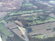
By: Big Orange Bird


